Siirt
| Siirt | |
|---|---|
| Municipality | |
|
City center | |
 Siirt | |
| Coordinates: 37°55′30″N 41°56′45″E / 37.92500°N 41.94583°ECoordinates: 37°55′30″N 41°56′45″E / 37.92500°N 41.94583°E | |
| Country | Turkey |
| Province | Siirt |
| Government | |
| • Mayor | Tuncer Bakırhan (BDP) |
| Area[1] | |
| • District | 283.87 km2 (109.60 sq mi) |
| Population (2012)[2] | |
| • Urban | 135,350 |
| • District | 145,784 |
| • District density | 510/km2 (1,300/sq mi) |
| Website |
www |

Siirt (Arabic: سِعِرْد Siʿird, Armenian: Սղերդ Sġerd, Syriac: ܣܥܪܬ siʿreth, Kurdish: Sêrt, Ottoman Turkish: سعرد) is a city in southeastern Turkey and the seat of Siirt Province. The population of the city according to the 2009 census was 129,188.[3] The majority of the city's population is Arabic and Kurdish.[4]
History
Previously known as Saird, in pre-Islamic times Siirt was an episcopacy of the Byzantine Church (Sirte, Σίρτη in Byzantine Greek). An illuminated manuscript known as the Syriac Bible of Paris may have originated from the Bishop of Siirt's library, Siirt's Christians would have worshipped in Syriac, a liturgical language related to Arabic still in use by the Chaldean Rite, other Eastern Christians in India, and the Nestorians along the Silk Road as far as China. The Chronicle of Seert was preserved in the city; it describes the ecclesiastical history of the Persian realm through the middle of the seventh century. From 1858 to 1915 the city was the seat of a bishop of the Chaldean Catholic Church. Most of the city's Assyrians, including their archbishop were killed during the Assyrian Genocide.[5]
Landmarks
The city's landmark is the Great Mosque (Ulu Cami) built in 1129 by the Great Seljuk Sultan Mahmut II who belonged to the main branch of the dynasty that ruled from Baghdad after this Turkish Empire had split into several branches. The mosque was restored in 1965.
Trivia
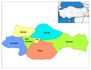
Siirt is famous in Turkey for its hand-made blankets (Siirt battaniyesi). Many visitors find themselves departing with one offered as a present. The traditional kilims produced by the Jirikan clan (aşiret) and revived since 1996 through joint efforts involving official instances and citizens are also much prized. Another product of interest is the Bıttım soaps proper to the region. Siirt also has an extremely rich culinary and spa culture. Depending district centers of Aydınlar (former Assyrian-rooted name was Tillo) with its historical medrese is renowned as a religious center and Pervari for its honey based on the particularly rich flora.
Siirt was Turkish Prime Minister Recep Tayyip Erdoğan's constituency from 2003 to 2007. His wife, Mrs. Emine Erdoğan, is from Siirt and the PM had been elected to the Turkish Grand National Assembly in a by-election held in Siirt in 2003.
Although Siirt remains one of the poorer cities in Turkey, some neighborhoods have fine and modern housing including new shops, banks and hotels.[6]
Climate
Siirt has a borderline continental and Mediterranean climate with very hot and dry summers and cold and wet winters. During winter months there is frequent frost and occasional snowfall.
| Climate data for Siirt | |||||||||||||
|---|---|---|---|---|---|---|---|---|---|---|---|---|---|
| Month | Jan | Feb | Mar | Apr | May | Jun | Jul | Aug | Sep | Oct | Nov | Dec | Year |
| Average high °C (°F) | 6.7 (44.1) |
8.9 (48) |
13.7 (56.7) |
19.4 (66.9) |
25.3 (77.5) |
32.3 (90.1) |
37.2 (99) |
37.0 (98.6) |
32.3 (90.1) |
24.4 (75.9) |
15.4 (59.7) |
8.8 (47.8) |
21.78 (71.2) |
| Average low °C (°F) | −0.2 (31.6) |
0.8 (33.4) |
4.4 (39.9) |
9.3 (48.7) |
13.8 (56.8) |
19.3 (66.7) |
23.6 (74.5) |
23.3 (73.9) |
18.9 (66) |
12.9 (55.2) |
6.3 (43.3) |
1.9 (35.4) |
11.19 (52.12) |
| Average precipitation mm (inches) | 83.2 (3.276) |
98.0 (3.858) |
104.7 (4.122) |
109.4 (4.307) |
60.2 (2.37) |
8.7 (0.343) |
1.9 (0.075) |
1.0 (0.039) |
4.7 (0.185) |
47.7 (1.878) |
79.6 (3.134) |
92.9 (3.657) |
692 (27.244) |
| Average rainy days | 11.5 | 12.0 | 13.8 | 13.5 | 10.3 | 3.4 | 0.8 | 0.6 | 1.7 | 8.1 | 9.1 | 11.7 | 96.5 |
| Average relative humidity (%) | 70 | 70 | 59 | 56 | 52 | 33 | 25 | 23 | 28 | 46 | 61 | 69 | 49.3 |
| Mean monthly sunshine hours | 111.6 | 123.2 | 173.6 | 201 | 285.2 | 354 | 384.4 | 359.6 | 306 | 226.3 | 156 | 108.5 | 2,789.4 |
| Source #1: Devlet Meteoroloji İşleri Genel Müdürlüğü [7] | |||||||||||||
| Source #2: Weatherbase [8] | |||||||||||||
Gallery
 A bridge in Siirt
 Ebul Vefa Mosque
 Eruh municipality
 A residential building in Siirt
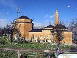 Ibrahim hakkı shrine in Siirt Tillo
.jpg) The city hall
The city hall Siirt Tillo
 Zorova river
External links
References
- ↑ "Area of regions (including lakes), km²". Regional Statistics Database. Turkish Statistical Institute. 2002. Retrieved 2013-03-05.
- ↑ "Population of province/district centers and towns/villages by districts - 2012". Address Based Population Registration System (ABPRS) Database. Turkish Statistical Institute. Retrieved 2013-02-27.
- ↑ Şehir, belde ve köy nüfusları – 2009 Archived October 4, 2011, at the Wayback Machine., Tuskish Institute of Statistics
- ↑ Watts, Nicole F. (2010). Activists in Office: Arabic and Kurdish Politics and Protest in Turkey (Studies in Modernity and National Identity). Seattle: University of Washington Press. p. 167. ISBN 978-0-295-99050-7.
- ↑ Gaunt, David; Beṯ-Şawoce, Jan (2006), Massacres, resistance, protectors: Muslim-Christian relations in Eastern Anatolia during World War I, Gorgias Press LLC, pp. 251–253, ISBN 978-1593333010 External link in
|title=(help) - ↑ Siirt in South East Turkey Photo Gallery by Dick Osseman at. Pbase.com. Retrieved on 2011-04-16.
- ↑ İl ve İlçelerimize Ait İstatistiki Veriler- Meteoroloji Genel Müdürlüğü Archived January 19, 2011, at the Wayback Machine.. Dmi.gov.tr. Retrieved on 2011-04-16.
- ↑ http://www.weatherbase.com/weather/weatherall.php3?s=1271&refer=&units=us&cityname=Siirt-Turkey