Signal Peak (Utah)
For other mountains by this name, see List of peaks named Signal.
| Signal Peak | |
|---|---|
 Signal Peak | |
| Highest point | |
| Elevation | 10,369 ft (3,160 m) NAVD 88[1] |
| Prominence | 4,485 ft (1,367 m) [1] |
| Listing | Utah county high points 21st[2] |
| Coordinates | 37°19′11″N 113°29′30″W / 37.3197027°N 113.4916207°WCoordinates: 37°19′11″N 113°29′30″W / 37.3197027°N 113.4916207°W [3] |
| Geography | |
 Signal Peak Location in Utah | |
| Location | Washington County, Utah, U.S. |
| Parent range | Pine Valley Mountains |
| Topo map | USGS Signal Peak |
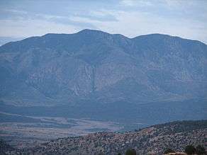
Signal Peak, with an elevation of 10,369 feet (3,160 m), is the highest peak in the Pine Valley Mountains and in Washington County in southwestern Utah, United States. Signal Peak is located north of the city of St. George and south of the community of Pine Valley in the Dixie National Forest.[4][5] The summit is the highest point in the Pine Valley Mountain Wilderness.[1]
Signal Peak is in the watershed of tributaries of the Virgin River, which itself is a tributary of the Colorado River.
A trail to the top can be found at oak grove campground in the neighboring city of Leeds, Utah.
References
- 1 2 3 "Signal Peak, Utah". Peakbagger.com. Retrieved 26 May 2012.
- ↑ "Utah County High Points". Peakbagger.com. Retrieved 2016-04-23.
- ↑ "Signal Peak". Geographic Names Information System. United States Geological Survey.
- ↑ "Signal Peak". SummitPost.org. Retrieved 26 May 2012.
- ↑ "Pine Valley Mountains". Peakbagger.com. Retrieved 26 May 2012.
External links
![]() Media related to Signal Peak (Utah) at Wikimedia Commons
Media related to Signal Peak (Utah) at Wikimedia Commons
This article is issued from Wikipedia - version of the 12/2/2016. The text is available under the Creative Commons Attribution/Share Alike but additional terms may apply for the media files.