Signal Knob (Virginia)
| Signal Knob | |
|---|---|
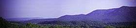 A view of Signal Knob, from Strasburg, Virginia | |
| Highest point | |
| Elevation | 2,106 ft (642 m) |
| Coordinates | 38°57′40″N 78°19′52″W / 38.96100°N 78.331°WCoordinates: 38°57′40″N 78°19′52″W / 38.96100°N 78.331°W |
| Geography | |
| Location | Shenandoah / Warren counties, Virginia, U.S. |
| Parent range | Ridge and Valley Appalachians |
| Topo map | USGS Strasburg Quad |
| Climbing | |
| Easiest route | Hike |
Signal Knob is the northern peak of Massanutten Mountain in the Ridge and Valley Appalachians with an elevation of 2,106 feet (642 m).[1] It is located in George Washington National Forest in Shenandoah County and Warren County in Virginia.
The peak offers expansive views into the northern Shenandoah Valley and the town of Strasburg, Virginia.
Signal Knob was used by Signal Corps in the American Civil War by both the Union and Confederate armies. The Confederates occupied it from 1862 to 1864, and it was a key observation point for the Battle of Cedar Creek.[2] On August 14, 1864, a group of Union troops won control of the peak by defeating a detachment of the 61st Georgia Volunteer Infantry.[3] Remains of Civil War era fortifications can still be seen around the area.[4]
The Massanutten Trail, maintained by the Potomac Appalachian Trail Club, leads hikers and mountain bikers up to Signal Knob. There are many loop options of varying lengths which may be combined with the Tuscarora Trail.[1] Trails in the Signal Knob area are known to be less crowded than Shenandoah National Park, to the east.[1]
Notes and references
- 1 2 3 "SummitPost - Signal Knob". Summit Post. December 31, 2008. Retrieved 2008-01-12.
- ↑ Wayland, John Walter (1980). A History of Shenandoah County, Virginia. Genealogical Publishing Com. pp. 187–189. ISBN 0-8063-8011-X.
- ↑ Coughlin, Bill. "Signal Knob Marker". HMDB.org - The Historical Marker Database. Retrieved 2009-01-13.
- ↑ "The Massanutten Mountain Trail, Virginia". Featured National Recreation Trails. The National Recreation Trails Program. Retrieved April 2, 2014.
During the Civil War, the Confederate and Union soldiers were ever present. The Shenandoah Valley was known as the bread-basket of the Confederacy and was the site of many battles. In October of 1864, Union forces burned most of the farm structures and stored grain facilities in Fort Valley as they marched through the area. Signal Knob, an overlook on the Massanutten Trail located at the far north end of the Massanutten[,] was used as a lookout and signal station by both Union and Confederate troops. Breast works used by both sides in defense of Signal Knob can still be seen.
External links
- Potomac Appalachian Trail Club Guide to Massanutten Mountain Hiking Trails
- Description of day hike loop to Signal Knob, with photos and map