Sierra de Tamaulipas
The Sierra de Tamaulipas is an isolated, semi-tropical mountain range in the Mexican state of Tamaulipas. Its highest point is 4,134 feet (1,260 mts). There are no cities or towns in the Sierra and the small population is largely agricultural. The higher elevations of the Sierra have forests of oak and pine, contrasting with the semi-arid brush that dominates at lower altitudes. Several archaeological sites establish that the Sierra de Tamaulipas was the northern outpost of the agricultural Mesoamerican peoples of eastern Mexico
Geography and climate
The Sierra de Tamaulipas is about 70 miles (110 km) north to south and 40 miles (64 km) east to west at its widest point in the southern part of the range. It covers a total area of 1,289 square miles (3,340 km2). The Sierra is located between 23 and 24 north latitude and 98 and 99 west longitude. Elevation ranges from 1,000 feet (300 m) to 4,134 feet (1,260 m).[1]
The Sierra de Tamaulipas has the characteristics of a Sky island—isolated from the Sierra Madre Oriental and rising high enough to have cooler and wetter conditions than the adjacent land at lower elevations. The area surrounding the Sierra at elevations below 1,000 feet (300 m) is vegetated primarily by a tropical thorn forest (Tamaulipan mezquital). The Sierra, with higher rainfall and lower temperatures, has three major vegetation types. Tropical deciduous forest (Veracruz moist forests) is found at elevations of 1,000 to 2,300 feet (300 to 700 m). The average height of this closed-canopy forest is about 25 feet (7.6 m). Montane scrub is found in dry areas between 2,000 and 2,900 feet (610 and 880 m) elevation. This vegetation type consists of low thickets and savanna. Huisache is a common shrub. Pine-oak forests found at elevations of greater than 2,600 feet (790 m) are an island of temperate forest in the ecoregion of Sierra Madre Oriental pine-oak forests. In areas undisturbed by agriculture and logging, vegetation at the higher altitudes can be luxuriant with many ferns.[2]
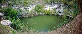
In the southeastern part of the Sierra in the municipality of Aldama, Tamaulipas is a limestone karst area in which many caves and cenotes (water-filled sinkholes) are found, including Zacatón which is the deepest sinkhole in the world with a depth of 1,112 feet (339 m).[3] In 1994, cave-diving pioneer Sheck Exley died attempting to dive to the bottom of Zacatón.
No major highways nor rivers cross the Sierra, nor are there any towns or cities. The population is rural. Abundant small, clear waterways drain from the highest points of the Sierra outward in all directions.
Precipitation in the Sierra de Tamaulipas ranges from about 28 inches (710 mm) at the lowest elevations to more than 40 inches (1,000 mm) at higher elevations. Most precipitation is in the summer between May and October, although winters are not as dry as in much of Mexico. Freezes are rare at lower elevations, but common in the temperate forests at higher altitudes. The climate of the hamlet of Santa Maria de los Nogales is typical of the higher elevations of the Sierra.
| Climate data for Santa Maria de los Nogales, Tamaulipas. 23 12 29N, 98 21 30W, Elevation: 3,041 ft (927 mts)(1950-2010) | |||||||||||||
|---|---|---|---|---|---|---|---|---|---|---|---|---|---|
| Month | Jan | Feb | Mar | Apr | May | Jun | Jul | Aug | Sep | Oct | Nov | Dec | Year |
| Record high °C (°F) | 36.0 (96.8) |
35.0 (95) |
40.0 (104) |
41.0 (105.8) |
43.5 (110.3) |
41.0 (105.8) |
39.0 (102.2) |
37.0 (98.6) |
37.0 (98.6) |
32.5 (90.5) |
36.0 (96.8) |
33.50 (92.3) |
43.5 (110.3) |
| Average high °C (°F) | 19.7 (67.5) |
21.4 (70.5) |
25.1 (77.2) |
27.3 (81.1) |
28.8 (83.8) |
28.6 (83.5) |
27.9 (82.2) |
27.8 (82) |
26.7 (80.1) |
24.6 (76.3) |
22.4 (72.3) |
20.0 (68) |
25.0 (77) |
| Daily mean °C (°F) | 13.8 (56.8) |
14.8 (58.6) |
17.9 (64.2) |
20.1 (68.2) |
22.3 (72.1) |
22.8 (73) |
22.6 (72.7) |
22.2 (72) |
21.3 (70.3) |
19.0 (66.2) |
16.9 (62.4) |
14.5 (58.1) |
19.0 (66.2) |
| Average low °C (°F) | 7.8 (46) |
8.3 (46.9) |
10.8 (51.4) |
13.0 (55.4) |
15.8 (60.4) |
16.9 (62.4) |
17.3 (63.1) |
16.6 (61.9) |
16.0 (60.8) |
13.5 (56.3) |
11.3 (52.3) |
9.0 (48.2) |
13.0 (55.4) |
| Record low °C (°F) | −5 (23) |
−5.5 (22.1) |
−2.0 (28.4) |
1.5 (34.7) |
5.5 (41.9) |
6.0 (42.8) |
7.5 (45.5) |
7.5 (45.5) |
6.0 (42.8) |
0.0 (32) |
−5.0 (23) |
−9.0 (15.8) |
−9.0 (15.8) |
| Average precipitation mm (inches) | 28.0 (1.102) |
16.0 (0.63) |
20.0 (0.787) |
37.0 (1.457) |
79.0 (3.11) |
135.0 (5.315) |
140.0 (5.512) |
158.0 (6.22) |
199.0 (7.835) |
87.0 (3.425) |
27.0 (1.063) |
39.0 (1.535) |
965.0 (37.992) |
| Average precipitation days (≥ 0.1 mm) | 5.8 | 4.1 | 3.2 | 4.4 | 7.2 | 8.8 | 9.4 | 11.1 | 11.7 | 7.4 | 5.9 | 6.2 | 85.2 |
| Source: Weatherbase: Santa Maria de los Nogales, Tamaulipas.[4] | |||||||||||||
Climatic classification. Cwa (Koppen); Cwab (Trewartha)
Pre-hispanic cultures
Due to greater precipitation than the surrounding lowlands, the Sierra de Tamaulipas was probably the northernmost area of eastern Mexico in which the cultivation of maize was practiced during pre-Hispanic times. Northward in the semi-arid brushlands extending into Texas lived the nomadic non-agricultural peoples collectively called Coahuiltecans.
Archaeologist Richard MacNeish found evidence of cultivation of maize in the Sierra de Tamaulipas dating from 2,500 BC which suggests a transition in culture from nomadic hunter-gathering to a more settled lifeway.[5] From 300 to 550 AD, several settlements in the Sierra de Tamaulipas comprised the northern outpost of the Mesoamerican Huastec culture. The Sierra settlements featured villages built around public squares and small pyramids, indicating a centralized and possibly theocratic government. The archaeological ruin of El Sabinito, about l3 miles (20 km) southwest of the city of Soto la Marina, is at the northern edge of the Sierra.[6] El Sabinito may have consisted of 600 houses with a population of 1,500 at its peak. It was abandoned about 1100 A.D., possibly because climatic changes made agriculture less feasible. Archaeologists speculate that the inhabitants reverted to a hunting-gathering means of subsistence.[7]
The first European to visit the coastal area adjacent to the Sierra was Francisco de Garay in 1523. Garay found maize cultivation up to about the Tropic of Cancer. From there northward lived hunter-gatherers who, according to Garay's men, were numerous and warlike on the lower stretches of the Soto La Marina River.[8]
References
- ↑ "Sierra de Tamaulipas: RTP-91" http://www.conabio.gob.mx/conocimiento/regionalizacion/doctos/rtp_091.pdf, accessed 26 Feb 2013
- ↑ Martin, Paul S., Robins, C. Richard, and Heed, William B. "Birds and Biogeography of the Sierra de Tamaulipas, an Isolated Pine-Oak Habitat" The Wilson Bulletin, Vol 66, No 1 (Mar 1954), pp. 41-42, 55
- ↑ http://www.ri.cmu.edu/publication_view.html?pub_id=6144; "Cenotes de Aldama: RTP-94" http://www.conabio.gob.mx/conocimiento/regionalizacion/doctos/rtp_094.pdf, accessed 26 Feb 2013
- ↑ "Travel Weather Averages". Weatherbase. Retrieved February 24, 2013.
- ↑ Fiedel, Stuart J. Prehistory of the Americas, London: Cambridge University Press, 1991, pp. 171-172
- ↑ "Turismo Arqueologico en Tamaulipas" [Archaeological tourism in Tamaulipas] (in Spanish). Visiting Mexico. Archived from the original on 10 November 2010. Retrieved Sep 2010. Check date values in:
|access-date=(help) - ↑ "Zona Arqueologica el Sabinito" http://www.inah.gob.mx/index.php?option=com_content&view=article&id=5500, accessed 3 Mar 2013
- ↑ Salinas, Martin. Indians of the Rio Grande Delta Austin: University of Texas Press, 1990, p. 73. In the opinion of most authorities, Salinas mistakenly identifies the Soto La Marina River as the Rio Grande.
Coordinates: 23°32′N 98°31′W / 23.533°N 98.517°W