Sierpc County
| Sierpc County Powiat sierpecki | ||
|---|---|---|
| County | ||
| ||
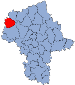 Location within the voivodeship | ||
 Division into gminas | ||
| Coordinates (Sierpc): 52°53′N 19°40′E / 52.883°N 19.667°ECoordinates: 52°53′N 19°40′E / 52.883°N 19.667°E | ||
| Country |
| |
| Voivodeship | Masovian | |
| Seat | Sierpc | |
| Gminas |
Total 7 (incl. 1 urban)
| |
| Area | ||
| • Total | 852.89 km2 (329.30 sq mi) | |
| Population (2006) | ||
| • Total | 53,811 | |
| • Density | 63/km2 (160/sq mi) | |
| • Urban | 18,791 | |
| • Rural | 35,020 | |
| Car plates | WSE | |
| Website | http://www.powiat.sierpc.pl | |
Sierpc County (Polish: powiat sierpecki) is a unit of territorial administration and local government (powiat) in Masovian Voivodeship, east-central Poland. It came into being on January 1, 1999, as a result of the Polish local government reforms passed in 1998. Its administrative seat and only town is Sierpc, which lies 117 kilometres (73 mi) north-west of Warsaw.
The county covers an area of 852.89 square kilometres (329.3 sq mi). As of 2006 its total population is 53,811, out of which the population of Sierpc is 18,791 and the rural population is 35,020.
Neighbouring counties
Sierpc County is bordered by Żuromin County to the north-east, Płońsk County to the east, Płock County to the south, Lipno County to the west and Rypin County to the north-west.
Administrative division
The county is subdivided into seven gminas (one urban and six rural). These are listed in the following table, in descending order of population.
| Gmina | Type | Area (km²) |
Population (2006) |
Seat |
| Sierpc | urban | 18.6 | 18,791 | |
| Gmina Sierpc | rural | 150.2 | 7,141 | Sierpc * |
| Gmina Zawidz | rural | 186.1 | 6,956 | Zawidz |
| Gmina Mochowo | rural | 143.6 | 6,249 | Mochowo |
| Gmina Gozdowo | rural | 126.7 | 6,041 | Gozdowo |
| Gmina Szczutowo | rural | 112.6 | 4,417 | Szczutowo |
| Gmina Rościszewo | rural | 115.1 | 4,216 | Rościszewo |
| * seat not part of the gmina | ||||
References
| Seat |
|  |
|---|---|---|
| Rural gminas | ||
