Sicklesmere
| Sicklesmere | |
 Sicklesmere |
|
| Shire county | Suffolk |
|---|---|
| Region | East |
| Country | England |
| Sovereign state | United Kingdom |
| Post town | Bury St Edmunds |
| Postcode district | IP30 |
| EU Parliament | East of England |
Coordinates: 52°12′36″N 0°44′53″E / 52.210°N 0.748°E
Sicklesmere is a village in Suffolk, England. Located on the A134 around a mile south of Bury St Edmunds, the village is divided between the civil parishes of Little and Great Whelnetham (where the population is included).
History
Recorded in 1272 as Sykolvesmere, that is, Sigolfr's mere (W. Rye, A Calendar of the Feet of Fines for Suffolk, 1900), the village is named after a mere or lake that used to be present near the River Lark. In truth it is no more than a small cluster of properties besides the River Lark. Many of these are flint built cottages.
A circular shaped building known as the Toll House is located on the main road. In the days of coach travel there was a regular service between Norwich and London via Sudbury which ran four times a day through Sicklesmere. The village was also previously served by Welnetham railway station until the Beeching Axe.
The village has a pub, the Rushbrooke Arms.[1]
Gallery
 River Lark at Sicklesmere
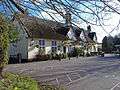 The Rushbrooke Arms
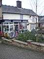 Village Store
References
External links
![]() Media related to Sicklesmere at Wikimedia Commons
Media related to Sicklesmere at Wikimedia Commons