Shot Tower, Taroona
| The Shot Tower | |
|---|---|
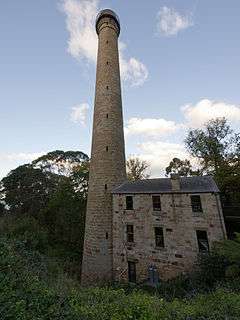 The Shot Tower at Taroona | |
| General information | |
| Type | Shot tower |
| Location | Taroona, Tasmania. |
| Country | Australia |
| Construction started | 1870 |
| Inaugurated | 8 September 1870 |
| Owner | Tasmanian government |
| Height | 48 metres |
| Dimensions | |
| Diameter | 10-3.9 metres |
| Technical details | |
| Material | Sandstone |
| Design and construction | |
| Architect | Joseph Moir |
| Engineer | Joseph Moir |
The Shot Tower at Taroona is a historic building shot tower between Hobart and Kingston, Tasmania. It was designed and built by Joseph Moir in 1870 in only eight months. One of only three remaining shot towers in Australia, it is alleged to be the tallest remaining shot tower in the world and the tallest ever built in the Southern Hemisphere,[1][2] which is disputed by the Clifton Hill Shot Tower.
It is however the sole claimant for the tallest stone shot tower in the Southern Hemisphere[3] and first shot tower in the Southern Hemisphere.[4] For four years it was the tallest building in Australia, and for one hundred years the tallest in Tasmania until it was superseded by the Mount Wellington broadcast tower.[4] The building is listed on the Tasmanian Heritage Register[5] and the Australian Register of the National Estate until that list was archived.[6]
It is attached to a historic house known as Queensborough Glen, which was the residence of Joseph Moir for many years. The Shot Tower now operates as a tourist attraction, with visitors able to climb to the top, and visit the attached cafe.
Height
The tower is variously listed as having a height of 157 feet (48 m),[3] 192 feet (59 m),[6] 172 feet (52 m)[1] or 192 feet (59 m)[2] with a diameter of either 10m[3] or 6.37m at the base[6] with either 291[2][6] or 316 steps.[1]
References
- 1 2 3 Smith, drawings by Max Angus ; text by Patsy Adam (1982). Hobart sketchbook (Rev. ed.). Adelaide: Rigby. p. 36. ISBN 0727000284.
- 1 2 3 Norris, Keith (1980). Australia's heritage sketchbook (New ed.). Sydney: Weldon Pub. pp. 30–31. ISBN 1863022988.
- 1 2 3 "Parks & Wildlife Service - History". www.parks.tas.gov.au. Parks & Wildlife Service. Retrieved 9 June 2016.
- 1 2 "Joseph Moir's Shot Tower". Atlas Obscura. Atlas Obscura.
- ↑ http://heritage.tas.gov.au/Documents/THR%20as%20at5Jan2016.pdf
- 1 2 3 4 "Australian Heritage Database". www.environment.gov.au.
Coordinates: 42°57′29″S 147°20′15″E / 42.95798°S 147.33748°E