Belt Parkway
| |
|---|---|
|
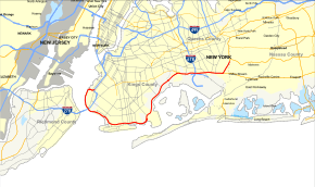
Map of New York City with Belt Parkway highlighted in red | |
| Route information | |
| Maintained by NYSDOT and NYCDOT | |
| Length: | 25.29 mi[1] (40.70 km) |
| Component highways: |
|
| Restrictions: | No commercial vehicles |
| Major junctions | |
| West end: |
|
|
| |
| East end: |
|
| Location | |
| Counties: | Kings, Queens |
| Highway system | |

The Belt System is a series of connected limited-access highways that form a belt-like circle around the New York City boroughs of Brooklyn and Queens. The system comprises four officially separate parkways; however, three of the four are signed as the Belt Parkway. The three parkways that make up the signed Belt Parkway—the Shore Parkway, the Southern Parkway (not to be confused with the Southern State Parkway), and the Laurelton Parkway—are a combined 25.29 miles (40.70 km) in length. The Cross Island Parkway makes up the fourth parkway in the system, but is signed separately.
Route description
The Shore Parkway, Southern Parkway, Laurelton Parkway, and Cross Island Parkway are collectively known as the "Belt System".[2] The four components of the Belt System are designated as New York State Route 907C (NY 907C), NY 907D, NY 907B, and NY 907A, respectively, by the New York State Department of Transportation. All four numbers are reference route designations and are not signed.[3] Excluding the Cross Island Parkway, the other three segments are now known collectively as the official "Belt Parkway". It is designated an east–west route, and its exit numbering system begins, in standard fashion, at the western terminus of the Shore Parkway, the westernmost parkway in the system. The numbering increases as the parkway proceeds eastward, and continues onto the Cross Island at the eastern terminus of the Belt Parkway. The north–south parkway retains the numbering scheme to its northern terminus.
Shore Parkway
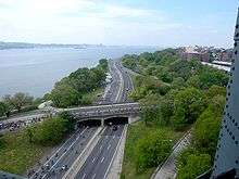
The Belt Parkway begins at an interchange (exit 22) with the Gowanus Expressway in the Bay Ridge section of Brooklyn. Paralleling Third Avenue, the parkway turns west and crosses over the New York and Atlantic Railway, a freight line. Bypassing Bay Ridge, the Belt enters exit 1, which services 65th–67th Streets in Bay Ridge. Crossing south past Owls Head Park, the parkway turns southward and enters Shore Road Park, paralleling the shore of the Upper New York Bay. The eastbound lanes, the Belt Parkway passes several small parking areas that services as a viewing spot for the bay. Connections across the parkway to Bay Ridge are also present at these parking areas. Beginning the bend to the southeast, the parkway passes Andrew Lehman Field.[4]
Just east of the field, the Belt Parkway comes within the shadows of the Verrazano-Narrows Bridge and enters exit 2, which serves as the southern terminus of Fourth Avenue. After crossing under the bridge, the westbound lanes enter exit 3 which connects to the Verrazano. Eastbound, the lanes from the bridge connecting to the Belt merge in, as the road enters Dyker Beach Park. During a short gap away from the shore, the Belt passes a parking area for Dyker Beach Park, entering exit 4, which services Bay 8th Street and 14th Avenue. Continuing along the park, the Belt begins to parallel Cropsey Avenue and passes another parking area before reaching exit 5, a junction with Bay Parkway. This marks the eastern end of Dyker Beach Park, and the route begins to parallel shoreline strip malls before reaching Calvert Vaux Park.[4]
Now in the Gravesend section of Brooklyn, the Belt enters exit 6, which connects to Cropsey Avenue. Westbound, this junction is split into exit 6N and exit 6S, also serving Stillwell Avenue. The parkway bends eastward and crosses over the Coney Island Complex, a large railroad yard for the New York City Subway. Just before entering exit 7, the eastbound lanes cross just north of the Neptune Avenue subway station. Exit 7 eastbound services Ocean Parkway, which is met by exit 7B proceeding westbound. Westbound, exit 7A services Shell Road in Gravesend. Paralleling the namesake Neptune Avenue, the parkway enters Sheepshead Bay and connections to Coney Island.[4]
At exit 8, the Belt Parkway connects to Coney Island Avenue, approaching the namesake bay as it continues east. Paralleling Emmons Avenue through Sheepshead Bay, the parkway enters exit 9A eastbound, which connects to Knapp Street and exit 9B, which is a ramp to the eastern end of Emmons Avenue. Westbound, exit 9 services Knapp Street. Crossing south of Gerritsen Beach, the parkway passes south of the Plum Beach Channel and passes a small rest area on the eastbound lanes. Turning northeast through the Floyd Bennett Field area, the parkway bends north and passes a service area with gas services in the median. Just north of the service area, the Belt enters exit 11N–S, a cloverleaf interchange which connects to Flatbush Avenue and the Rockaways.[4]
After exit 11N, the Belt Parkway continues east through Floyd Bennett Field, crossing over the Mill Basin Drawbridge into Brooklyn Beach and passes the entrance to the Jamaica Bay Riding Academy, the only business served directly on the parkway. Crossing over another bridge, the parkway enters the Canarsie section of Brooklyn. The parkway, now running northeast, parallels a bicycle path, reaching Canarsie Pier and exit 13, which serves as the southern end of Rockaway Parkway. Crossing over another bridge over Spring Creek, the parkway enters exit 14, which connects to Pennsylvania Avenue in Starrett City. The interchange is adjacent to the former Pennsylvania Avenue Landfill. After crossing another waterway, Hendrix Creek, the Belt passes the former Fountain Avenue Landfill and enters exit 15, a diamond interchange with Erskine Street leading to the Gateway Center shopping complex.[4]
Now crossing over the Old Mill Basin section of Jamaica Bay, the Belt Parkway continues northeast in the borough of Queens, entering exit 17N–S, Cross Bay Boulevard and Cohancy Street, which also connects to the Cross Bay Bridge and towards the Rockaways. Crossing into an interchange with NY 27, the parkway travels under the IND Rockaway Line (A train) and passes exit 18B, which connects to Aqueduct Racetrack in Ozone Park.[4]
Southern and Laurelton parkways
Now on the Southern Parkway section of the Belt, the Belt continues eastward into exit 19, which connects to NY 878 (the Nassau Expressway) and indirectly with I-678, the Van Wyck Expressway. This interchange also serves as access to John F. Kennedy International Airport. Now with North and South Conduit Avenues serving as westbound and eastbound frontage roads for the parkway, passing exit 20, a junction with the JFK Expressway and the airport. Crossing under the Van Wyck, the Belt continues east through multiple underpasses and overpasses before reaching exit 21A, westbound side, which services 150th Street and Rockaway Boulevard. Crossing under Guy R. Brewer Boulevard, the Belt enters exit 21B, which connects to Farmers Boulevard and Guy R. Brewer Boulevard.[4]
Exit 22 services Springfield Boulevard, where the Belt Parkway begins to parallel a Long Island Rail Road line through Laurelton. Westbound, exit 23A services North Conduit Boulevard (NY 27) and 225th Street, while eastbound, exit 23B services NY 27 and the Sunrise Highway. At this junction, the parkway turns northeast and joins the Laurelton Parkway segment, which connects to exit 24A, Merrick Boulevard in both directions, and Francis Lewis Boulevard on the eastbound lanes. Exit 24B on the eastbound lanes connects also to Merrick Boulevard and 130th Avenue and on the westbound lanes connect Francis Lewis Boulevard. Just after crossing under 130th Avenue, the Belt enters exit 25A–B. At this interchange, the Laurelton Parkway segment ends, with exit 25A connecting to the western terminus of the Southern State Parkway and exit 25B servicing Elmont Road.[4]
At this interchange, the Belt Parkway crosses over the Southern State and becomes the Cross Island Parkway, which continues north through Queens, connecting to I-495, the Grand Central Parkway and eventually I-678, the Whitestone Expressway.[4]
History
The Belt Parkway was proposed by builder and highway advocate Robert Moses on February 25, 1930 to provide modern highway access to Manhattan and to connect to, and use similar design principles to, parkways already constructed on Long Island and Westchester County, New York.[5]
In a 1937 report titled “New Parkways in New York City” The New York City Parks department proposed the Belt Parkway in the following outline:
“The Circumferential Parkway begins at Owl's Head Park at the Narrows, and follows the Shore Drive through Fort Hamilton and Dyker Beach Park. The City of New York was vested title in an extension along Gravesend Bay to Bensonhurst Park, and is about to acquire the remaining rights-of-way up to Guilder Avenue, including sufficient land for the conversion of Guilder Avenue into a genuine parkway with service roads. It is proposed to acquire the rights-of-way for the extension of Guilder Avenue by means of a new parkway parallel to, and north of Emmons Avenue to the Marine Parkway extension, for which land is already in the possession of the City. It is proposed to carry the Circumferential Parkway from Flatbush Avenue where the Marine Parkway extension ends, along or near Jamaica Bay to a point on Southern Parkway, just east of the Rockaway division of the Long Island Railroad in Queens. It should be noted that work on the conversion of the Sunrise Highway into a genuine parkway is already under way. This will be known as Southern Parkway.”[5]
Construction began in 1934, new highway designs were implemented - dark colored main roads and lighter colored entrance and exit ramps. The full loop was completed when the Brooklyn–Queens Expressway (also known as the "BQE") was finished in 1960.
In numbers, the completed Belt Parkway can be summarized thusly,
- 11.8 million cubic yards of hydraulic fill pumped
- 4.8 million cubic yards of dry fill moved
- 1.5 million square yards of pavement used
- 530,000 cubic yards of concrete used
- 11,500 cubic yards of masonry used
- 400,000 lineal feet of piles used
- 320,000 tons of steel used
- 9,000 men employed[5]
The Belt System
Though some signage bears the name "Belt Parkway," the original plan never called for a highway of that name, rather a system of different named parkways called the "Belt System." The Belt System is made up of a series of interconnecting highways, none of which are actually named the Belt Parkway. Originally, the highways were the Gowanus Parkway from the Brooklyn–Battery Tunnel to the Shore Parkway; the entirety of the Shore, Southern, Laurelton, and Cross Island Parkways; the Whitestone Parkway from the Cross Island to the Grand Central Parkway; and the Grand Central from the Whitestone to the Triborough Bridge.
All the original parkways, except the Gowanus, were built on grassy rights-of-way with trees, in a more pleasant surrounding than most highways of their time. The Gowanus Parkway, in part replacing the demolished Fifth Avenue Line, was built as an elevated structure over Third and Hamilton Avenues in order to avoid the active docks and industrial areas including Sunset Park, Brooklyn.
Conversion and completion
Like most parkways in New York State, the parkways comprising the Belt System were closed to commercial traffic, including any vehicle with a non-passenger registration and all commercial trucking of any size. Originally even station wagons, which had "suburban" registrations, were excluded but they were later allowed, along with passenger-registered SUVs and vans.
The system was not completed as a parkway, and some portions of the original system were converted to expressways, which allows commercial traffic to use them. These expressway portions included the Gowanus Expressway, replacing Gowanus Parkway as a connector between Manhattan and the Verrazano-Narrows Bridge to Staten Island and New Jersey (now signed as part of I-278); Whitestone Expressway, which converted Whitestone Parkway into a truck route to connect the Van Wyck Expressway to the Bronx–Whitestone Bridge (now signed as part of I-678); and the Brooklyn–Queens Expressway, built as an expressway to connect the Gowanus Parkway/Expressway to the Triborough Bridge and Grand Central Parkway to complete the system (now signed as part of I-278).
In 1969, the New York City Council renamed the Shore Parkway Leif Ericson Drive between exit 2 and exit 9, to recognize the large Scandinavian population in Bay Ridge.[6]
Exit list
| County | Location | mi[1][7] | km | Exit | Destinations | Notes |
|---|---|---|---|---|---|---|
| Kings | Sunset Park | 0.00 | 0.00 | – | Exit 22 on I-278 | |
| Bay Ridge | 0.80– 1.20 | 1.29– 1.93 | 1 | 65th–67th Streets | Access via Shore Road | |
| Fort Hamilton | 3.10– 3.50 | 4.99– 5.63 | 2 | 4th Avenue / Fort Hamilton Parkway – Verrazano Bridge | ||
| 3.70 | 5.95 | 3 | Westbound exit and eastbound entrance; exit 16 on I-278 | |||
| Fort Hamilton– Bath Beach | 4.47 | 7.19 | 4 | Bay 8th Street / 14th Avenue | ||
| Bath Beach– Gravesend | 5.63 | 9.06 | 5 | Bay Parkway | ||
| Gravesend | 6.40– 6.80 | 10.30– 10.94 | 6 | Cropsey Avenue / Stillwell Avenue – Coney Island | Signed as 6S (south) and 6N (north) westbound | |
| 7.40– 8.20 | 11.91– 13.20 | 7A | Shell Road – Coney Island | Westbound exit and eastbound entrance; formerly exit 7S | ||
| 7B | Ocean Parkway – Coney Island, Brighton Beach | Signed as exit 7 eastbound; formerly exits 7S and 7N | ||||
| Sheepshead Bay | 7.80– 8.50 | 12.55– 13.68 | 8 | Coney Island Avenue – Brighton Beach | ||
| 9.30– 10.20 | 14.97– 16.42 | 9 | Knapp Street – Sheepshead Bay | Split into exits 9A and 9B eastbound; both lead to Knapp Street | ||
| Gerritsen Inlet | 10.70 | 17.22 | Bridge | |||
| Floyd Bennett Field | 11.30– 11.80 | 18.19– 18.99 | 11 | Flatbush Avenue – Rockaways, Marine Park | Signed as exits 11S (south) and 11N (north) | |
| Mill Basin Inlet | 12.25 | 19.71 | Bridge | |||
| Bergen Beach | 12.70 | 20.44 | – | Jamaica Bay Riding Academy | Eastbound exit and entrance | |
| Paerdegat Basin | 13.55 | 21.81 | Bridge | |||
| Canarsie | 14.38 | 23.14 | 13 | Rockaway Parkway | ||
| Fresh Creek Basin | 15.00 | 24.14 | Bridge | |||
| East New York | 15.42 | 24.82 | 14 | Pennsylvania Avenue | ||
| 15.60 | 25.11 | Bridge over Hendrix Creek | ||||
| 16.20 | 26.07 | 15 | Erskine Street | |||
| Spring Creek | 16.55 | 26.63 | Bridge | |||
| Queens | Howard Beach | 17.60– 19.00 | 28.32– 30.58 | 17 | Cross Bay Boulevard / Cohancy Street – Woodhaven, Rockaways | Signed as 17S (south) and 17N (north) westbound |
| 17W | Westbound exit and eastbound entrance | |||||
| South Ozone Park | 18.70– 19.20 | 30.09– 30.90 | 18B | Lefferts Boulevard – Aqueduct Racetrack | Eastbound exit is part of exit 19 | |
| 18.30– 20.20 | 29.45– 32.51 | 19 | Westbound access to Kennedy Airport is via exit 20; exit 1 on I-678 | |||
| 21.00– 21.30 | 33.80– 34.28 | 20 | Westbound exit and eastbound entrance; north end of JFK Expressway | |||
| Springfield Gardens– Rochdale | 19.60– 21.50 | 31.54– 34.60 | 21A | 150th Street / Rockaway Boulevard | Signed as exit 20 eastbound | |
| 21.20– 22.20 | 34.12– 35.73 | 21B | Farmers Boulevard / Guy R. Brewer Boulevard | No eastbound access to Guy R. Brewer Boulevard | ||
| 21.80– 22.40 | 35.08– 36.05 | 22 | Springfield Boulevard | |||
| Laurelton–Brookville | 22.80 | 36.69 | 23B | Eastbound exit and westbound entrance | ||
| Laurelton–Rosedale | 23.30 | 37.50 | 23A | Westbound exit only | ||
| 23.40– 23.70 | 37.66– 38.14 | 24A | Francis Lewis Boulevard / Merrick Boulevard | No westbound signage for Merrick Boulevard | ||
| 23.90 | 38.46 | 24B | Merrick Boulevard (westbound) / 130th Avenue (eastbound) | |||
| Cambria Heights | 24.60 | 39.59 | 25A | West end of Southern Parkway | ||
| 24.70 | 39.75 | 25B | Elmont Road / Linden Boulevard | Northbound exit only; other movements via Cross Island Parkway | ||
| 25.29 | 40.70 | – | South end of Cross Island Parkway | |||
| 1.000 mi = 1.609 km; 1.000 km = 0.621 mi | ||||||
See also
-
.svg.png) New York Roads portal
New York Roads portal
References
- 1 2 "2008 Traffic Volume Report for New York State" (PDF). New York State Department of Transportation. June 16, 2009. p. 253. Retrieved April 1, 2010.
- ↑ "Bridge Inventory Manual – Appendix G: State Touring Route Numbers for Named Roads" (PDF). New York State Department of Transportation. April 2005. Retrieved April 1, 2010.
- ↑ New York State Department of Transportation (January 2012). Official Description of Highway Touring Routes, Bicycling Touring Routes, Scenic Byways, & Commemorative/Memorial Designations in New York State (PDF). Retrieved February 16, 2012.
- 1 2 3 4 5 6 7 8 9 Microsoft; Nokia (February 2, 2013). "overview map of the Belt Parkway" (Map). Bing Maps. Microsoft. Retrieved February 2, 2013.
- 1 2 3 "Belt Parkway". Nycroads.com. Retrieved 2014-05-04.
- ↑ "Belt Parkway/Shore Parkway". New York City Department of Parks and Recreation. Retrieved June 18, 2013.
- ↑ Google (January 6, 2016). "Belt Parkway" (Map). Google Maps. Google. Retrieved January 6, 2016.
External links
| Wikimedia Commons has media related to Belt Parkway. |
- Belt Parkway at Alps' Roads • New York State Highway Termini
- Belt Parkway Historic Overview at Steve Anderson's nycroads.com
- Belt Parkway (Greater New York Roads)
- Belt Parkway (Jeff's Parkway Site: Photo Gallery)