Shizunai River
| Shizunai River (Shizunai-gawa) | |
| 静内川 | |
| River | |
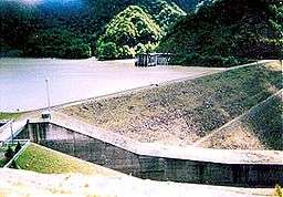 Takami Dam (November 2006) | |
| Name origin: Ainu language: Shiputnai — A marsh at the origin of the Ainu or Shuttonai — A marsh with lots of grapes or Shutnai — A river at the foot of a mountain. | |
| Country | Japan |
|---|---|
| State | Hokkaidō |
| Region | Hidaka Subprefecture |
| District | Hidaka District |
| Municipality | Shinhidaka |
| Tributaries | |
| - left | Hidaka Mena River (日高目名川 Hidaka Mena-gawa), Mount Sumi River (炭山 Sumi-yama-kawa), Shunbetsu River, Penkeonikemushi River, Ponpanbetsu Creek, Penkebetsusawa River, Porokaunnai River |
| - right | Perari River, Poyoppusawa River, Pisenaisawa River, Ibetsusawa River, Abeunnai River |
| Source confluence | Koikakushushibichari River and Koibokushushibichari River |
| - elevation | 300 m (984 ft) |
| - coordinates | JP 42°28′22″N 142°45′05″E / 42.47278°N 142.75139°E |
| Mouth | Pacific Ocean |
| - elevation | 0 m (0 ft) |
| - coordinates | JP 42°19′47″N 142°22′05″E / 42.32972°N 142.36806°ECoordinates: JP 42°19′47″N 142°22′05″E / 42.32972°N 142.36806°E |
| Length | 69.9 km (43 mi) |
| Basin | 683.4 km2 (264 sq mi) |
Shizunai River (静内川 Shizunai-gawa) is a river in Shinhidaka, Hokkaidō, Japan. The Shizunai River drains from the Hidaka Mountains into the Pacific Ocean.
Etymology
The Shizunai River was known as Shibuchari[1] and Shibechari. This name was derived from Shipe-ichan, meaning "a salmon spawning place" in Ainu.[2]
The name Shizunai is derived from the Ainu language and has three possible sources:[3]
- Shiputnai – A marsh at the origin of the Ainu.
- Shuttonai – A marsh with lots of grapes.
- Shutnai – A river at the foot of a mountain.
Course
The Shizunai River flows generally southwest from its headwaters in the Hidaka mountains at the confluence of the Koikakushushibichari and Koibokushushibichari rivers. It flows into Lake Takami (高見湖 Takami-ko), a reservoir created by the Takami Dam. Past the dam, the Shizunai river flows into Shizunai Flood Control Reservoir (静内調整池 Shizunai Chōseichi). Past the Shizunai Dam, the river encounters Futa Dam before leaving the mountains for the flood plain. The river flows past the outlying communities of Shizunai before entering the Pacific Ocean just northwest of Shizunai harbor.
Natural history
The Shizunai River was designated as a wildlife protection area in 1965. Whooper swans overwinter on the Shizunai River.[2]
History
The Shizunai River basin was the home of Shakushain the Ainu leader who led a revolt against the Japanese especially the Matsumae clan in the 1660s. In the Edo period the region was used for gold mining.
Lists
List of bridges and dams
From river mouth to source:
- Shizunai Bridge (静内橋 Shizunai Bashi)
- Rubeshibe Bridge (碧蘂 橋 Rubeshibe Bashi)
- Misono Bridge (御園橋 Misono Bashi)
- Futa Dam (双ダム Futa Damu)
- Shizunai Dam (静内ダム Shizunai Damu)
- Menashi River Bridge (目梨別橋 Menashibetsu Bashi)
- Takami Dam (高見ダム Takami Damu)
- Takami Bridge (高見橋 Takami Bashi)
- Ibetsu Bridge (威別大橋 Ibetsu Ōhashi)
List of (named) tributaries
From river mouth to source:
- Left — Hidaka Mena River (日高目名川 Hidaka Mena Gawa)
- Right — Perari River
- Left — Mount Sumi River (炭山 Sumiyama Kawa) charcoal or coal mountain river
- Left — Shunbetsu River
- Right — Poyoppusawa River
- Right — Pisenaisawa River
- Left — Penkeonikemushi River
- Left — Ponpanbetsu Creek
- Left — Penkebetsusawa River
- Left — Porokaunnai River
- Right — Ibetsusawa River
- Right — Abeunnai River
- Confluence Left — Koibokushuchchari, Right — Koikakushuppichari
References
- ↑ Walker, The Conquest of Ainu Lands, pgs 18–19
- 1 2 Nippon-Kichi, 静内川 Shizunai-gawa The Shizunai River, last access 26 May 2008
- ↑ Akagi Sanpei (赤木 三兵), Journey of Hokkaidō Place Names—Notes on Ainu Language Place Names (北海道 地名の旅—アイヌ語地名解 Hokkaidō Chimei no Tabi — Ainugo Chimei Kai)
- Brett L. Walker, The Conquest of Ainu Lands, University of California Press, Berkeley, 2001, ISBN 0-520-24834-1
- Akagi Sanpei (赤木 三兵), Journey of Hokkaidō Place Names—Notes on Ainu Language Place Names (北海道 地名の旅—アイヌ語地名解 Hokkaidō Chimei no Tabi — Ainugo Chimei Kai), Sanon Cultural Publication (山音文学公刊 Sanon Bungaku Kōkan), No year of publication.
- Nippon-Kichi, 静内川 Shizunai-gawa The Shizunai River, 12 July 2007, last access 26 May 2008