Shiraoi, Hokkaido
| Shiraoi 白老町 | ||
|---|---|---|
| Town | ||
| ||
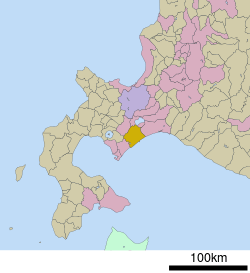 Location of Shiraoi in Hokkaido (Iburi Subprefecture) | ||
 Shiraoi Location in Japan | ||
| Coordinates: 42°33′N 141°21′E / 42.550°N 141.350°ECoordinates: 42°33′N 141°21′E / 42.550°N 141.350°E | ||
| Country | Japan | |
| Region | Hokkaido | |
| Prefecture | Hokkaido (Iburi Subprefecture) | |
| District | Shiraoi | |
| Area | ||
| • Total | 425.75 km2 (164.38 sq mi) | |
| Population (31 May 2008) | ||
| • Total | 20,998 | |
| • Density | 49/km2 (130/sq mi) | |
| Symbols | ||
| • Tree | Sorbus commixta (ナナカマド Nanakamado) | |
| • Flower | Lespedeza bicolor (エゾヤマハギ Ezo-yama-hagi) | |
| Time zone | Japan Standard Time (UTC+9) | |
| City hall address |
1-1-1 Ōmachi, Shiraoi-chō, Shiraoi-gun, Hokkaidō 059-0995 | |
| Website |
www | |
Shiraoi (白老町 Shiraoi-chō) is a town located in Shiraoi District, Iburi, Hokkaido, Japan. As of 31 May 2008, the town had a population of 20,371[1] The town was established in 1867 by the feudal lords of Sendai. Most of the area of the town is forested and parts lie within the Shikotsu-Tōya National Park.
History
Shiraoi like the rest of Hokkaido was populated by the Ainu. According to the town's official website, the name, Shiraoi, means Rainbows are frequent here in the Ainu language.[2] Other sources state that the name comes from Shiraunai meaning Horse-flies are common here.[3]
In 1867 the Sendai domain established a fort in Shiraoi and work began on Shiogama Shrine (塩釜神社 Shiogama Jinja). The following year the Boshin War caused Sendai to retreat from Shiraoi and return to Sendai proper. After the revolt was put down the government dismantled the fort in 1870.
The end of the 19th century saw expansion of the town. A road was established connecting Shiraoi with Muroran, Sapporo, and Hakodate in 1873. Nineteen years later the first railroad station was established. The villages of Shadai and Shikiu were established. Two significant events occurred during this expansion: in 1874 Mount Tarumae erupted and in 1881 the Emperor Meiji visited.[4]
Geography
The total area is 425.72 square kilometres (164.37 sq mi). The town is 28.0 kilometres (17.4 mi) East to West and 26.4 kilometres (16.4 mi) North to South.[1] 82% of this area is forested.[2]
| Use | Percentage |
|---|---|
| Mountains and forest | 74 |
| Other | 9 |
| Plains and moor | 6 |
| Ranchland | 4 |
| Farmland | 2 |
| Housing | 2 |
| Mixed use | 2 |
| Wet lands | 1 |
Shiraoi is crossed by a number of rivers running from the mountains like Mount Horohoro to the Pacific Ocean. These include:
- Shadai River
- Shiraoi River
- Shikyu River
- Betsubetsu River
Mount Horohoro and Lake Kuttara are part of Shikotsu-Tōya National Park. Lake Poroto is also a place of natural beauty.
Climate
Shiraoi has an oceanic climate, mild when compared to the rest of Hokkaido. The annual temperature ranges between the extremes of 27.8 °C (82.0 °F) and −20.8 °C (−5.4 °F). The average annual temperature is 7.2 °C (45.0 °F). Shiraoi receives 1,660 millimetres (65 in) of precipitation annually. This only results in 103 centimetres (41 in) of snow annually. In a typical year, the snow lingers for 80 days. Accumulated snow rarely exceeding 44 centimetres (17 in). Wind velocity averages merely 1.6 metres per second (3.6 mph), that is less than half of the neighboring Tomakomai and Muroran.[5]
Demographics
Shiraoi has a density of 47.86 persons per km².
| Year | Households | Population |
|---|---|---|
| 1899 | 848 | 3659 |
| 1919 | 988 | 4906 |
| 1920 | 1906 | 6312 |
| 1925 | 1348 | 6849 |
Economy
In the 1930s Shiraoi began the cultivation of mushrooms,[6] such as Shiitake, and mullet roe (or karasumi) at Kojohama. Shiraoi imported the knowledge of mullet roe production from Iwanai.[7]
Shiraoi has been involved in the harvest of marine products such as the Horsehair crab and konbu. Because of dwindling resources harvesting of hair crab has been reduced to a test operation from the middle of July until the middle of August.[7]
Shiraoi introduced the raising of beef cattle from Shimane Prefecture in 1954. In 1966 Shiraoi began with the production of chicken eggs. Shiraoi boasts 550,000 chickens and a business worth ¥2.8 billion.[6]
Arts and culture
Annual cultural events
Shiraoi has four annual festivals:[8]
- Shiraoi Dosanko Winter Festival — early February
- Shiraoi Beef Festival — early June
- Shiraoi Port Festival — early August
- Shiraoi Cheipu Festival — early September
Museums and other points of interest
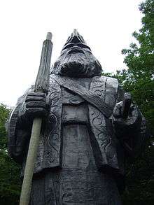
- The Ainu Museum, commonly known as Poroto Kotan – A natural history museum depicting a traditional Ainu village. Performers show traditional crafts and dances like the yomante rimuse.[9]
- Lake Kuttara
- Inkura Falls
- Mount Horohoro
- Ayoro Beach
- Ruin of the Sendai Domain Shiraoi Founding Encampment Historical Landmark (史跡仙台藩白老元陣屋跡 Shiseki Sendai-han Shiraoi Moto-jinya Ato)
- Sendai Domain Shiraoi Founding Encampment Resource Center (仙台藩白老元陣屋資料館 Sendai-han Shiraoi Moto-jinya Shiryōkan)
- Kojohama hotsprings
Education
Elementary schools:[1]
- Shiraoi Elementary School (白老小学校 Shiraoi Shōgakkō)
- Shadai Elementary School (社台小学校 Shadai Shōgakkō)
- Midorigaoka Elementary School (緑丘小学校 Midorigaoka Shōgakkō)
- Hagino Elementary School (萩野小学校 Hagino Shōgakkō)
- Takeura Elementary School (竹浦小学校 Takeura Shōgakkō)
- Kojō Elementary School (虎杖小学校 Kojō Shōgakkō)
Middle Schools:[1]
- Shiraoi Middle School (白老中学校 Shiraoi Chūgakkō)
- Hagino Middle School (萩野中学校 Hagino Chūgakkō)
- Takeura Middle School (竹浦中学校 Takeura Chūgakkō)
- Kojō Middle School (虎杖中学校 Kojō Chūgakkō)
Other Schools:[1]
- Education Support Center (教育支援センター Kyōikushien Sentā)
Infrastructure
Transportation
Shiraoi has several stations on the Muroran Main Line:
- Kojōhama
- Takeura
- Kita-yoshihara
- Hagino
- Shiraoi
- Shadai
Shiraoi is served by the following bus companies:
- Donan bus Co.,Ltd
- Hokkaido Chuo Bus Co., ltd.
Shiraoi is served by the following roads and highways:
- Hokkaidō Expressway
- Interchange at Shiraoi
- Parking area at Hagino
- National highways:
- Prefectural roads:
- Hokkaidō Highway 86
- Hokkaidō Highway 350
- Hokkaidō Highway 388
- Hokkaidō Highway 701
- Hokkaidō Highway 1045
Sister cities
Shiraoi has the following twin city relationships:[10]
-
 Quesnel, Canada since 1981
 -
 Sendai, Japan since 1981
 - Morita (now part of Tsugaru), Japan since 1991
Sports
The Shadai Stallion Station is located here. Shadai Stallion Station has bought high-profile thoroughbreds for their breeding program, such as Kentucky Derby winner War Emblem.[11]
References
- 1 2 3 4 5 6 "Shiraoi Official Web Page" (in Japanese). Shiraoi Town. 2006-10-03. Retrieved 2008-06-12.
- 1 2 "Local". Shiraoi Town. 2006-10-03. Retrieved 2008-06-12.
- ↑ Akagi Sanpei (赤木 三兵), Journey of Hokkaidō Place Names—Notes on Ainu Language Place Names (北海道 地名の旅—アイヌ語地名解 Hokkaidō Chimei no Tabi — Ainugo Chimei Kai), pg 65.
- ↑ "History 1800". Shiraoi Official Website. 2006-10-03. Retrieved 2008-06-13.
- ↑ "Topology and Climate". Shiraoi Official Website. 2002-11-25. Retrieved 2008-06-16.
- 1 2 "Products". Shiraoi Town. 2006-10-03. Retrieved 2008-06-16.
- 1 2 "Marine Products". Shiraoi Town. 2006-10-03. Retrieved 2008-06-16.
- ↑ "Festival". Shiraoi Town. 2006-10-03. Retrieved 2008-06-16.
- ↑ Bisignani, J.D. (December 1993). "Donan-Southern Hokkaido". In Taran March. Japan Handbook (Second ed.). Chico, California: Moon Publications, Inc. pp. 792–793. ISBN 0-918373-70-0.
- ↑ "Town Profile". Shiraoi Official Website. Retrieved 2008-06-13.
- ↑ Drape, Joe (April 28, 2008). "A Pampered Derby Champion's Finicky Taste". The New York Times. Retrieved 2008-06-16.
External links
 Media related to Shiraoi, Hokkaidō at Wikimedia Commons
- Official website (Japanese) (some English content)
- The Ainu Museum