Shillelagh, County Wicklow
| Shillelagh Síol Éalaigh | |
|---|---|
| Village | |
|
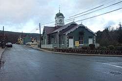
Shillelagh Courthouse | |
 Shillelagh Location in Ireland | |
| Coordinates: 52°45′18″N 6°32′10″W / 52.755°N 6.536°WCoordinates: 52°45′18″N 6°32′10″W / 52.755°N 6.536°W | |
| Country | Ireland |
| Province | Leinster |
| County | County Wicklow |
| Elevation | 65 m (213 ft) |
| Population (2016)[1] | |
| • Total | 586 |
| Irish Grid Reference | S986681 |
Shillelagh (Irish: Síol Éalaigh) is a village in County Wicklow, Ireland. It is located in the south of the county, on the R725 regional road from Carlow to Gorey. The River Derry, a tributary of the River Slaney, flows through the village, while the Wicklow Way passes to the north and west.
The village was planned as part of the FitzWilliam estate in the 17th century. In 2011, it had a population of 341.
Sport
Shillelagh has a Gaelic Athletic Association team and a soccer team. The team colours are sky blue and navy. Coollattin Golf Club, an 18-hole parkland course, is located just east of the village.
Transport
Shillelagh railway station opened on 22 May 1865, at the end of a branch from Woodenbridge via Aughrim and Tinahely. It closed to passengers and goods traffic on 24 April 1944, and altogether on 20 April 1945.[2] The station building was subsequently converted to a private residence.[3]
References
- ↑ "2016 Preliminary Census Results". Central Statistics Office. 2016.
- ↑ Ayres, Bob (2003). "Irish Railway Stations" (PDF). Railscot. Retrieved 24 November 2007.
- ↑ "Shillelagh Railway Station, Shillelagh, County Wicklow". National Inventory of Architectural Heritage. Retrieved 3 October 2016.
External links
- Historic Wicklow lodge has great potential Article about Coolattin Lodge, a farmhouse on the FitzWilliam estate.
- A Wee Look at the History of County Wicklow Information about the FitzWilliam Estate.
- Shillelagh at Wicklow Tourism
- Shillelagh GAA information at Wicklow GAA
- Street View of Shillelagh on Google Maps
Places in County Wicklow | ||
|---|---|---|
| Towns |  | |
| Villages |
| |
| ||