Sheriff Hutton
| Sheriff Hutton | |
 Finkle Street, Sheriff Hutton |
|
 Sheriff Hutton |
|
| Population | 1,019 (2011) |
|---|---|
| OS grid reference | SE652664 |
| District | Ryedale |
| Shire county | North Yorkshire |
| Region | Yorkshire and the Humber |
| Country | England |
| Sovereign state | United Kingdom |
| Post town | YORK |
| Postcode district | YO60 6 |
| Police | North Yorkshire |
| Fire | North Yorkshire |
| Ambulance | Yorkshire |
| EU Parliament | Yorkshire and the Humber |
| UK Parliament | Thirsk and Malton (formerly Ryedale) |
Coordinates: 54°05′22″N 1°00′17″W / 54.08939°N 1.004703°W
Sheriff Hutton is a village and civil parish in the Ryedale district of North Yorkshire, England. It lies about ten miles north by north-east of York.
History
The village is mentioned twice in the Domesday Book as Hotun in the Bulford hundred. Before the Norman invasion the manor was split between several land owners. Those named included Ligulf, Northmann, Thorkil, Thorsten and Thorulf. Afterwards some of the land was retained by the Crown and others given to Count Robert of Mortain who installed Sir Nigel Fossard as lord of the manor.[1] Soon after this, the land was in the possession of the Bulmer family. Bertram de Bulmer built the first castle in the village during the reign of King Stephen.[2] After the civil war between Stephen and Matilda, the castle and manor were seized by the Crown before being held for the king by the Mauley family. The manor eventually came into the possession of the Nevill family in the 14th century until 1480, when they were surrendered to the Crown. Various grants of land were made up to the 17th century when possession is recorded as belonging to Sir Thomas Ingram. The Ingram family, by way of various marriages, maintained lordship until 1904, when it passed to Hon. Edward Frederick Lindley Wood.[3]
Topynomy
The name is derived from the Old English words hoh and tun, together meaning settlement on a projecting piece of land.[4] The prefix of Sheriff is thought to arise because it was once held by Bertram de Bulmer, the Sheriff of York, who died in 1166.[2]
Castles
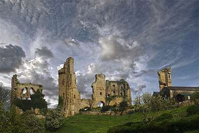
In 1140, during the reign of King Stephen, a motte-and-bailey castle was built here in the Forest of Galtres by Bertram de Bulmer, the remains of which can be seen to the south of the churchyard.[3] Those remains have been designated Ancient Monument status.[5]
The extant remains of the stone Castle at the western end of the village were built by John, Lord Neville in the late fourteenth century. It fell into disrepair during the reign of King James I.[2] It is a Grade II Listed Building.[6]
The Nevill Castle was used by Richard III to house his nephew Edward, Earl of Warwick and his niece, Elizabeth of York.[2]
Governance
The village lies within the Thirsk and Malton (UK Parliament) constituency. The village gives its name to the District ward of Ryedale District Council. It also gives it name to the Hovingham and Sheriff Hutton electoral division of North Yorkshire County Council in which it sits.[7]
The local Parish Council is made of six members.[8]
An electoral ward in the same name exists. This ward stretches south east to Flaxton with a total population taken at the 2011 Census of 1,729.[9]
Geography
The nearest settlements are West Lilling 0.8 miles (1.3 km) to the south, Thornton-le-Clay 2.2 miles (3.5 km) to the south east and Farlington 2.3 miles (3.7 km) to the north east.[7]
The 2001 UK Census recorded the population as 1,038, of which 842 were over the age of sixteen years. There were 448 dwellings, of which 239 were detached.[10] The population at the 2011 Census was 1019.[11]
Amenities
Economy
There are a diverse range of small to medium size businesses in and around the village from traditional building and contracting to small IT firms. There are also two public houses.[12] The village is served by the York to Helmsley bus route.[13]
Sports
The Village Hall provides facilities for Badminton as well as other multi-function events. There is a Tennis Club with two hard courts on North Garth Lane. The Bowls Club have a green and clubhouse next to the Cricket Ground. Sheriff Hutton Cricket Club have their pavilion and clubhouse next to the Village Hall grounds.[14]
Religion

The parish Church is dedicated to St Helen and Holy Cross and was built in the early 12th century. It is a Grade I Listed Building.[15] The chancel was added in the 13th century and there were other rebuilding work carried out in both 14th and 15th centuries.
An alabaster cenotaph with an effigy of a child was long regarded to depict Edward of Middleham, son of Richard III and Anne Neville, but is now thought to be an earlier work and depicts one of the Neville family.[2][3][16][17]
There is also a Methodist church in the village near the school. Wesleyan and Primitive Methodist chapels were built in the 19th century.[2][18]
Education
There is a school in the village, Sheriff Hutton Primary School, and is within the catchment area of Easingwold School for secondary education.[19]
The village had a school attached to the early Wesleyan chapel which was built in 1855, but no longer in use. In 1873, the wife of the lord of the manor paid for the building of a National School in the village.
References
- ↑ Sheriff Hutton in the Domesday Book. Retrieved 20 January 2013.
- 1 2 3 4 5 6 Bulmer's Topography, History and Directory (Private and Commercial) of North Yorkshire 1890. S&N Publishing. 1890. pp. 787–790. ISBN 1-86150-299-0.
- 1 2 3 "History". Retrieved 20 January 2013.
- ↑ "Topynomy". Retrieved 20 January 2013.
- ↑ "Ancient Monument". Retrieved 20 January 2013.
- ↑ "Castle Listing".
- 1 2 Ordnance Survey Open Viewer
- ↑ "Parish Council". Retrieved 20 January 2013.
- ↑ "Key Figures for 2011 Census: Key Statistics – Area: Sheriff Hutton (Ward)". Neighbourhood Statistics. Office for National Statistics. Retrieved 18 January 2016.
- ↑ "2001 UK Census". Neighbourhood Statistics. Office for National Statistics. Retrieved 20 January 2013.
- ↑ "Parish population 2011". Neighbourhood Statistics. Office for National Statistics. Retrieved 13 August 2015.
- ↑ "Businesses". Retrieved 20 January 2013.
- ↑ "Transport". Retrieved 20 January 2013.
- ↑ "Sports Clubs". Retrieved 20 January 2013.
- ↑ "Church Listing". Retrieved 20 January 2013.
- ↑ Routh P. and Knowles R (1982). The Sheriff Hutton Alabaster Reconsidered. Wakefield Historical Publications.
- ↑ Crease, Jane (March 2013). "The Monument at Sheriff Hutton (Yorkshire): is this the tomb of Richard III's son?". Church Monuments Society. Retrieved 15 May 2014.
- ↑ "Methodist Church". Retrieved 20 January 2013.
- ↑ "School Information". Retrieved 20 January 2013.
External links
| Wikimedia Commons has media related to Sheriff Hutton. |