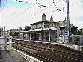
Shelford railway station
| Shelford | |
|---|---|
 | |
| Location | |
| Place | Great Shelford |
| Local authority | District of South Cambridgeshire |
| Grid reference | TL465522 |
| Operations | |
| Station code | SED |
| Managed by | Abellio Greater Anglia |
| Owned by | Network Rail |
| Number of platforms | 2 |
| DfT category | E |
|
Live arrivals/departures, station information and onward connections from National Rail Enquiries | |
| Annual rail passenger usage* | |
| 2010/11 |
|
| 2011/12 |
|
| 2012/13 |
|
| 2013/14 |
|
| 2014/15 |
|
| History | |
| Key dates | Opened 1845 |
| National Rail – UK railway stations | |
| * Annual estimated passenger usage based on sales of tickets in stated financial year(s) which end or originate at Shelford from Office of Rail and Road statistics. Methodology may vary year on year. | |
|
| |
Shelford railway station serves the villages of Great Shelford, Little Shelford and Stapleford in Cambridgeshire, England.
History
The station was opened by the Eastern Counties Railway in 1845[1] and later became a junction with the opening of the Stour Valley Railway from Haverhill on 1 June 1865.[2] The subsequent completion of the line onwards to Sudbury a few months later created a through link with Colchester on the Great Eastern main line. This was used by through holiday trains between Clacton-on-Sea and the East/West Midlands in LNER and British Rail days but then fell victim to the Beeching Axe, closing to all traffic on 6 March 1967.[3]
Service Patterns
A train leaves hourly in each direction off peak and half-hourly peak. The 'Up' (London) train calls at Whittlesford, Great Chesterford, Audley End, Newport (Essex), Elsenham, Stansted Mountfitchet, Bishops Stortford, Sawbridgeworth, Harlow Mill, Harlow Town, Roydon, Broxbourne, Cheshunt and Tottenham Hale before terminating at Liverpool Street.[4]
The 'Down' train (away from London) goes to Cambridge.
References
- ↑ "Great Shelford conservation area" (PDF). scambs.gov.uk. South Cambridgeshire District Council. 2007. p. 5. Retrieved 24 July 2016.
- ↑ Wallis, Andy T (2011). Stour Valley Railway part 2 Through Time; Clare to Shelford & Audley End. Stroud: Amberley. p. 2. ISBN 9781445604732.
- ↑ "Disused Stations - LintonDisused Stations Site Record;; Retrieved 17 June 2016
- ↑ Table 22 National Rail timetable, May 2016
External links
- Train times and station information for Shelford railway station from National Rail
- "Estimates of Station Usage". orr.gov.uk. Office of Rail Regulation. Retrieved 14 March 2015.
| Preceding station | |
Following station | ||
|---|---|---|---|---|
| Whittlesford Parkway | Abellio Greater Anglia West Anglia Main Line |
Cambridge | ||
| Disused railways | ||||
| Cambridge Line and station open |
Great Eastern Railway Stour Valley Railway |
Pampisford Line and station closed | ||
Coordinates: 52°08′56″N 0°08′24″E / 52.149°N 0.140°E