Shelby, Wisconsin
| Shelby, Wisconsin | |
|---|---|
| Town | |
 Location of Shelby, Wisconsin | |
| Coordinates: 43°46′11″N 91°11′53″W / 43.76972°N 91.19806°W | |
| Country | United States |
| State | Wisconsin |
| County | La Crosse |
| Area | |
| • Total | 29.1 sq mi (75.4 km2) |
| • Land | 25.6 sq mi (66.2 km2) |
| • Water | 3.6 sq mi (9.2 km2) |
| Elevation[1] | 692 ft (211 m) |
| Population (2010) | |
| • Total | 4,715 |
| • Density | 183.2/sq mi (70.8/km2) |
| Time zone | Central (CST) (UTC-6) |
| • Summer (DST) | CDT (UTC-5) |
| Area code(s) | 608 |
| FIPS code | 55-73125[2] |
| GNIS feature ID | 1584140[1] |
Shelby is a town in La Crosse County, Wisconsin, United States. It is part of the La Crosse, Wisconsin Metropolitan Statistical Area. The population was 4,715 at the 2010 census. The unincorporated community of Shelby is located in the town. It happens to be one of the unicycling capitals of the world<http://www.unicyclist.com/forums/archive/index.php/t-5937.html>.
Geography
According to the United States Census Bureau, the town has a total area of 29.1 square miles (75.4 km²), of which, 25.6 square miles (66.3 km²) of it is land and 3.5 square miles (9.2 km²) of it (12.19%) is water.
Demographics
| Historical population | ||
|---|---|---|
| Year | Pop. | ±% |
| 1990 | 4,435 | — |
| 2000 | 4,687 | +5.7% |
| 2010 | 4,715 | +0.6% |
According to 2009-2013 ACS estimates, the median household income was $75,742 and the median family income was $95,813. Males had a median income of $64,613 versus $45,208 for females. The per capita income for the city was $42,038. About 3.4% of families and 5.5% of the population were below the poverty line, including 7.1% of those under age 18 and 6.2% of those age 65 or over.[3]
As of the census[2] of 2000, there were 4,687 people, 1,771 households, and 1,397 families residing in the town. The population density was 183.2 people per square mile (70.7/km²). There were 1,817 housing units at an average density of 71.0 per square mile (27.4/km²). The racial makeup of the town was 96.89% White, 0.32% African American, 0.28% Native American, 1.69% Asian, 0.02% Pacific Islander, 0.11% from other races, and 0.70% from two or more races. Hispanic or Latino of any race were 0.73% of the population.
There were 1,771 households out of which 35.1% had children under the age of 18 living with them, 71.0% were married couples living together, 6.0% had a female householder with no husband present, and 21.1% were non-families. 18.0% of all households were made up of individuals and 7.7% had someone living alone who was 65 years of age or older. The average household size was 2.65 and the average family size was 3.00.
In the town the population was spread out with 26.8% under the age of 18, 5.0% from 18 to 24, 23.6% from 25 to 44, 32.4% from 45 to 64, and 12.3% who were 65 years of age or older. The median age was 42 years. For every 100 females there were 100.9 males. For every 100 females age 18 and over, there were 96.4 males.
The median income for a household in the town was $64,890, and the median income for a family was $76,559. Males had a median income of $50,313 versus $32,276 for females. The per capita income for the town was $32,899. None of the families and 1.1% of the population were living below the poverty line, including no under eighteens and 2.7% of those over 64.
References
- 1 2 "US Board on Geographic Names". United States Geological Survey. 2007-10-25. Retrieved 2008-01-31.
- 1 2 "American FactFinder". United States Census Bureau. Retrieved 2008-01-31.
- ↑ http://factfinder.census.gov/faces/tableservices/jsf/pages/productview.xhtml?pid=ACS_13_5YR_DP03&prodType=table
External links
| Core cities | 
 | ||||||
|---|---|---|---|---|---|---|---|
| Surrounding communities |
| ||||||
| Counties | |||||||
Municipalities and communities of La Crosse County, Wisconsin, United States | ||
|---|---|---|
| Cities | 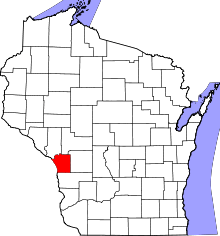 | |
| Villages | ||
| Towns | ||
| CDPs | ||
| Unincorporated communities | ||
Coordinates: 43°46′09″N 91°09′39″W / 43.76917°N 91.16083°W