Shaw Conference Centre
| Shaw Conference Centre | |
|---|---|
|
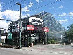
Shaw Conference Centre main entrance | |
| Location |
9797 Jasper Avenue Edmonton, Alberta, Canada T5J 1N9 |
| Coordinates | 53°32′29″N 113°29′9″W / 53.54139°N 113.48583°W |
| Owner | City of Edmonton |
| Opened | 1983 |
Construction cost |
C$81.8 million[1] ($179 million in 2016 dollars[2]) |
| Enclosed space | |
| • Total space | 144,406 sq ft (13,415.8 m2) |
The Shaw Conference Centre (colloquially called The Shaw, or SCC), is a meeting, entertainment, and convention venue located in Edmonton, Alberta, Canada. The doors to the SCC opened in 1983 and since 1993 it has been managed by Edmonton Economic Development Corporation (EEDC), a not-for-profit enterprise owned by the City of Edmonton.
Formerly the Edmonton Convention Centre, its current name comes from a $5.5 million, 20 year corporate partnership between EEDC and Shaw Communications Inc., signed in 1997.[3]
It is reported by EEDC that the SCC boosts Edmonton's economy by an estimated $44 million a year.[4]
History
The area in Grierson Hill where the Shaw Conference Centre now resides was originally a coal mine in operation from 1892 and 1893, allowing for approximately 70 per cent of the SCC to be located underground. This burrowing conceals the fact the building is over 10 stories high.[5]
James Wensley, a local Edmontonian, was the architect for the SCC and was awarded the Alberta Association of Architects Citation in 1983 for his work on the facility. Other notable works in the City from this architect include the Manulife, Scotia Place and Sunlife buildings.
Location
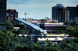
The Shaw Conference Centre is located on Jasper Avenue and 97th street and can be seen in Edmonton's skyline. The Jasper Avenue entrance opens onto the centre's glass atrium, which in turn serves as the entrance to the conference level. Nearby are over 2,000 downtown hotel rooms plus shopping, entertainment venues, dining and North America’s largest park system.[6]
The long outer walls on the centre's assembly and meeting levels offer a view of the North Saskatchewan River valley parks system; a view which stretches from the downtown core to the north campus of the University of Alberta. The centre is linked via pedway to Edmonton's Canada Place, which is the main property for federal government offices in Edmonton. Canada Place is linked, in turn, to many other buildings by way of Edmonton's pedway system, including, the Citadel Theatre, the Westin Hotel, the City Hall, the Sutton Place Hotel, and the Edmonton City Centre mall.
Function
The function of the Shaw Conference Centre is to boost local industry. Besides hosting trade shows, meetings and conventions, the SCC is also a music and entertainment venue. It has hosted a wide variety of guests and performers in its history, including Big Sugar, Tiesto, Bobby Orr, Pearl Jam, Judas Priest, Megadeth, Metallica, Marilyn Manson, Slipknot, Stone Temple Pilots, Paul Rodgers, Scorpions, Goo Goo Dolls, Dream Theater, In Flames, Deftones, Sum 41, Jean Chrétien, Desmond Tutu, Gordie Howe, Prince Charles, The Cult, Diana Princess of Wales, Tina Turner, Slayer, Disturbed, Lamb of God and Avenged Sevenfold.[7]
Notes
- ↑ "Shaw centre needs to grow or lose out: report". Edmonton Journal. Postmedia Network. February 7, 2011. Retrieved April 26, 2013.
- ↑ Canadian inflation numbers based on Statistics Canada. "Consumer Price Index, historical summary". CANSIM, table (for fee) 326-0021 and Catalogue nos. 62-001-X, 62-010-X and 62-557-X. And Consumer Price Index, by province (monthly) (Canada) Last modified 2016-01-22. Retrieved March 2, 2016
- ↑ Media Release February 6, 1997, Economic Development Edmonton and Shaw Communications Inc.
- ↑ Page 23 of “Forward” Edmonton Economic Development’s 2008 Annual Report
- ↑ Small mine in operation 1892 - 1893 (Real Estate & Housing, pg 12, 1978)
- ↑ http://www.edmonton.ca/attractions_recreation/parks_rivervalley/parks-healthy-by-nature.aspx
- ↑ Shaw Conference Centre - A History of Edmonton's Meeting Place, Tiffany E. Nelson, 2001
External links
Coordinates: 53°32′29″N 113°29′9″W / 53.54139°N 113.48583°W