Shahr-e Kord
| Shahr-e Kord شهركرد Ancient names: Dezh Gord, Deh Kord | |
|---|---|
| city | |
 | |
| Nickname(s): The city of kindness, Bam e Iran (Roof of Iran) | |
 Shahr-e Kord Shahr-e Kord in Iran | |
| Coordinates: 32°19′32″N 50°51′52″E / 32.32556°N 50.86444°ECoordinates: 32°19′32″N 50°51′52″E / 32.32556°N 50.86444°E | |
| Country |
|
| Province | Chaharmahal and Bakhtiari |
| County | Shahr-e Kord |
| Bakhsh | Central |
| Elevation | 2,070 m (6,790 ft) |
| Population (2006) | |
| • Total | 148,464 |
| Time zone | IRST (UTC+3:30) |
| • Summer (DST) | IRDT (UTC+4:30) |
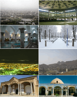
Shahr-e Kord (Persian: شهركرد, also Romanized as Shahr-e Kord and Shahr Kord[1]) is the capital city of Chaharmahal and Bakhtiari Province, Iran. It is the largest city in the province, and is 90 km away from Iran's third largest city, Isfahan. At the time of the 2006 census, Shahr-e Kord had a population of about 148,464 and the Shahr-e Kord metropolitan area had a population of 380,312.[2]
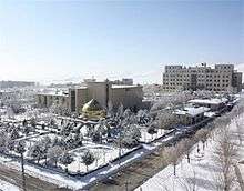
Shahr-e Kord is famous for its natural beauty, cold winters, waterfalls and rivers. Shahr-e Kord is the Iran’s highest capital city at 2,070 m (6,790 ft) above the sea level. This led to be known as “Roof of Iran”.
Shahr-e Kord is about 100 km (62 mi) from Iran's third largest city of Isfahan and 521 km (324 mi) from Tehran.
Its weather is dry, cold in winter and mild in summer. The town has a ski resort (Bardeh) located about 35 km (22 mi) away and several natural lagoons and small lakes for outdoor relaxation.
Name
In antiquity, before the Islamic occupation of Persia, it had been called "Dezh Gord" (دژگرد). The word Dezh (دژ) means fortress and the word Gord (گرد) means "Hero". After the Muslim conquest of Persia and the supremacy of the Arabic language, its name was changed to "Deh Kord" Persian: دهكرد, because the arabic alphabet lacks the letters “zh” (ژ) and “g” (گ).[3] The name of the city was changed from "Deh Kord" to "Shahr-e-Kord" in 1935. There are some other cities such as Chamgordan, Boroujerd and Dezful which were called Chamgord, Borougord and Dezhpol, respectively, before the Muslim conquest of Persia. The name of the city, in Kurdish and Persian, means the "city of Kurds".
People
Currently, people living in Shahr-e Kord are of three major backgrounds: Bakhtiari, Qashqai and indigenous Persian speakers of Shahr-e Kord; however, the people of Shahr-e Kord speak Persian as a lingua franca. Shahr-e Kord is assumed to be first developed by nomadic farmers because it encompasses vast meadows and several springs. Deh Kord was gradually founded by the immigrants from Isfahan, its suburbs, and the villages around Shahr-e Kord, most of whom started to run businesses such as agriculture, horticulture, hat making, felt making, oil and wool trading, and other industries.
Geography
Shahr-e Kord is located about 90 km (56 mi) southwest of Isfahan and 512 km (318 mi) of Tehran. It is topographically situated in the north of the Zagros Mountains. Being located 2,070 m (6,790 ft) above the sea level, Shahr-e Kord is the most elevated among the centers of the provinces of Iran, known as the Roof of Iran.
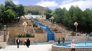 Mellat Park, ShahreKord
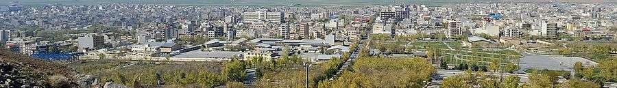
 Bazaar Intersection, core of the City
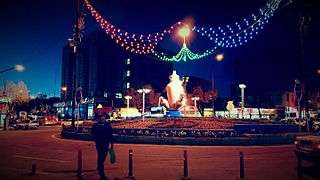 Abi Square
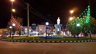 Ferdowsi Square
 Imam Hossein Square
Climate
Shahr-e Kord enjoys a cold semi-arid climate (BSk, according to the Köppen climate classification) with hot summer days, mild summer nights, cool winter days and cold winter nights. The annual average temperature in Shahr-e Kord is about 5.11 °C but the minimum and maximum absolute temperatures recorded in Shahr-e Kord during the last 30 years have been -32 °C and 42 °C, respectively. December is the coldest month and July is the hottest month. Although the humidity level is moderate or high in winter, the amount of rainfall is close to zero in planting seasons, except for April and May.
| Climate data for Shahr-e Kord | |||||||||||||
|---|---|---|---|---|---|---|---|---|---|---|---|---|---|
| Month | Jan | Feb | Mar | Apr | May | Jun | Jul | Aug | Sep | Oct | Nov | Dec | Year |
| Average high °C (°F) | 4.6 (40.3) |
7.4 (45.3) |
13.0 (55.4) |
18.5 (65.3) |
24.9 (76.8) |
31.6 (88.9) |
34.3 (93.7) |
33.6 (92.5) |
30.0 (86) |
23.1 (73.6) |
15.3 (59.5) |
8.5 (47.3) |
20.4 (68.7) |
| Average low °C (°F) | −8 (18) |
−5.2 (22.6) |
−0.3 (31.5) |
4.1 (39.4) |
7.6 (45.7) |
10.6 (51.1) |
14.5 (58.1) |
13.0 (55.4) |
8.0 (46.4) |
3.6 (38.5) |
−0.1 (31.8) |
−4.4 (24.1) |
3.6 (38.5) |
| Average precipitation mm (inches) | 60.9 (2.398) |
50.3 (1.98) |
56.9 (2.24) |
42.8 (1.685) |
14.6 (0.575) |
0.7 (0.028) |
1.8 (0.071) |
0.5 (0.02) |
0.0 (0) |
8.7 (0.343) |
32.8 (1.291) |
59.9 (2.358) |
329.9 (12.989) |
| Average precipitation days | 8.5 | 7.4 | 8.5 | 7.3 | 4.5 | 0.3 | 0.6 | 0.5 | 0.0 | 2.6 | 5.3 | 7.2 | 52.7 |
| Source: World Meteorological Organisation | |||||||||||||
Business and Industry
- Barfab Company manufactures various types of home appliances including Evaporative cooler, Gas/ Kerosene/ Electric Water Heaters, Gas Space Heater, Refrigerator - Freezer and Twin-Tub Washing Machine. Hiring about 1400 human resources within the firm, Barfab is the biggest private unit in the province.
- Kordcement.com/AboutUsenglish.php Shahr-e Kord cement Co is located in the center of the mountain range of Zagros, 35 km away from Shahr-e Kord city.
- Shahr-e Kord Zagros Steel Company engages in the manufacturing of cast iron.
- Farokh Shahr Steel Industries is a tinplate producer. It is located 10 km away from Shahr-e Kord city.
- Shahr-e Kord Carbon Dixde Corp. is the largest producer of CO2 and Dry Ice in Iran.
- Shahr-e Kord Textile Industries Co founded in Shahr-e Kord in 1991, is a fabric retail store which specializes in clothing fabrics, polyester viscose and black Chador.
- PAK PAY CO founded in Shahr-e Kord in 1991, is a dairy factory which produces pasteurized milk, flavored milk, cheese and yogurt. In 1996, Pak Dairy Co bought approximately 99% of company's stock.
Education

There are three universities in the city of Sharekord, the most popular being Shahrekord University(SKU) with 5,713 students. The other universities are Shahrekord University of Medical Sciences (SKUMS) with 1,690 students and Islamic Azad University of Shahr-e Kord Branch(IAUSHK) with 7,400 students.
Sister cities
References
- ↑ Shahr-e Kord can be found at GEOnet Names Server, at this link, by opening the Advanced Search box, entering "-3084174" in the "Unique Feature Id" form, and clicking on "Search Database".
- ↑ "Census of the Islamic Republic of Iran, 1385 (2006)". Islamic Republic of Iran. Archived from the original (Excel) on 2011-11-11.
- ↑ http://www.tebyan-chb.ir/Tebyan/ostan/about-ostan/ostan.aspx
- ↑ http://www.farsnews.com/newstext.php?nn=13900612000453
External links
| Wikimedia Commons has media related to Shahr-e Kord. |
| Capital |  | ||||||||||||||||||||||||||
|---|---|---|---|---|---|---|---|---|---|---|---|---|---|---|---|---|---|---|---|---|---|---|---|---|---|---|---|
| Counties and cities | |||||||||||||||||||||||||||
| Landmarks |
| ||||||||||||||||||||||||||
| populated places | |||||||||||||||||||||||||||
| Capital | |||||||||||||||||||||||||||||||||||||||||||||||||||||||||||||||
|---|---|---|---|---|---|---|---|---|---|---|---|---|---|---|---|---|---|---|---|---|---|---|---|---|---|---|---|---|---|---|---|---|---|---|---|---|---|---|---|---|---|---|---|---|---|---|---|---|---|---|---|---|---|---|---|---|---|---|---|---|---|---|---|
| Districts |
| ||||||||||||||||||||||||||||||||||||||||||||||||||||||||||||||