Shah Alam
| Shah Alam شاه عالم | |||
|---|---|---|---|
| City and State Capital | |||
|
The Esplanade at Shah Alam | |||
| |||
|
Nickname(s): Bandar Anggerik (Orchid City) | |||
|
Motto: 'Indah Bestari' (Beautiful, Brilliant) | |||
 Location within Petaling District (and a portion of Klang District) and the state of Selangor | |||
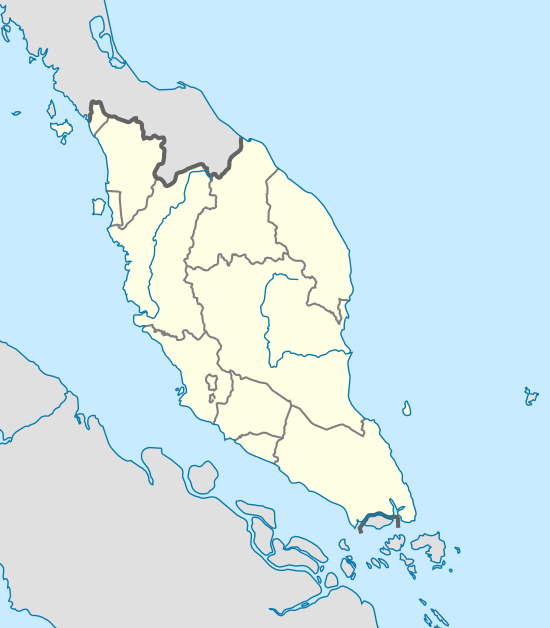 Shah Alam Location in the Peninsula Malaysia | |||
| Coordinates: 3°5′00″N 101°32′00″E / 3.08333°N 101.53333°E | |||
| Country | Malaysia | ||
| State | Selangor | ||
| District | Petaling and Klang | ||
| Establishment | 1963 | ||
| Granted State Capital Status | 7 December 1978 | ||
| Government | |||
| • Mayor | Datuk Ahmad Zaharin Mohd Saad | ||
| Area | |||
| • Total | 232.3 km2 (89.7 sq mi) | ||
| Population (June 2011) | |||
| • Total | 723,890 (Census 2,016) | ||
| Time zone | MST (UTC+8) | ||
| • Summer (DST) | Not observed (UTC) | ||
| Website |
www | ||


Shah Alam /ʃɑː ˈɑːləm/ is a city and the state capital of Selangor, Malaysia and situated within the Petaling District and a small portion of the neighbouring Klang District. Shah Alam replaced Kuala Lumpur as the capital city of the state of Selangor in 1978 due to Kuala Lumpur's incorporation into a Federal Territory in 1974. Shah Alam was the first planned city in Malaysia after independence from Britain in 1957.
History
Malaysia grew rapidly after its independence in 1957 under the "Father of Modernisation", the second Prime Minister of Malaysia, Allahyarham Tun Abdul Razak Hussein. Shah Alam was once known as Sungai Renggam and was noted for its rubber and oil palm estates. Later, the same area was identified as Batu Tiga prior to Malaysian independence, and has been a centre of rubber and palm oil trade for centuries. The Sungai Renggam Plantation was earmarked for the development of a township by the Selangor government in 1963, and under the recommendations of V. Antolic, a town planning advisor from the United Nations, chose the present site strategically located between Kuala Lumpur and Port Klang.[1]
Its current name was chosen by the then state Sultan of Selangor, Sultan Salahuddin Abdul Aziz Shah, after his late father Sultan Alam Shah. Many other monuments, buildings and even a street are named after the late Sultan. Shah Alam was opened in 1963 with the purpose of making it the new administrative centre of Selangor, replacing Kuala Lumpur which was made a Federal Territory on 1 February 1974. With the consent of 8th Duli Yang Maha Mulia Sultan of Selangor, Almarhum Sultan Salahuddin Abdul Aziz Shah Al-Haj, Shah Alam was proclaimed the capital of Selangor on 7 December 1978 with an area of 41.68 km2, and administrated by a municipal council. Shah Alam had encountered several processes of extending its areas and the last was on 1 January 1997. Through the Gazette Plan 1190, Shah Alam was extended to 293 km2.[2]
Shah Alam was granted city status on 10 October 2000 with Dato' Haji Abu Sujak Haji Mahmud as the first mayor. He recently served as deputy Menteri Besar, or Chief Minister of Selangor. Abu Sujak declared the vision of making Shah Alam a modern city with a unique identity of "Bandaraya Melayu" or Malay City, showcasing the achievements of the Malay race in all sectors. In line with this identity, Shah Alam was declared the first city in the world with no entertainment outlets to avoid any vice activities.[3][4]
Geography
Shah Alam is located within the district of Petaling and a portion of the district of Klang in the state of Selangor. Due to its recent expansion, it is bordered by the cities of Subang Jaya and Petaling Jaya in the east, the district of Klang in the west, the district of Kuala Selangor and Gombak in the north, and the district of Kuala Langat in the south. Shah Alam is also one of the major cities within the Klang Valley, an area in Malaysia comprising Kuala Lumpur and its suburbs, and adjoining cities and towns in the state of Selangor, due to the Klang River flowing through it on its way westward to the Strait of Malacca.[2]
Cityscape

Shah Alam has a similar urban layout to Petaling Jaya or Subang Jaya with housing areas occupying most of the city (55.2 km2) and commercial centres scattered around the different 'Seksyen' (sections). There are 56 sections in total. Generally Shah Alam can be divided into three parts; the north, central and south parts. North Shah Alam consists of 18 Sections including Sections U1 and U2 and Kampung Melayu Subang. The Central Shah Alam is where all the state administrative buildings and agencies are situated. It consists of Section 1 until Section 24 (seen in the map as beige coloured areas). South Shah Alam consists of 12 sections including Section 25 (Taman Sri Muda), Section 30 (Jalan Kebun), Section 31 (Kota Kemuning) and Section 32 (Bukit Rimau). In the map, south Shah Alam is seen as the light purple coloured areas.
The city has a number of shopping malls (Aeon Shah Alam Seksyen 13, Plaza Alam Sentral, (also known as PAS), SACC Mall, Plaza Shah Alam (formerly known as Shah Alam Mall, also known as Plaza Masalam), Ole-Ole Seksyen 18, Anggerik Mall and Kompleks PKNS). Vibrant commercial areas are situated mostly at the city centre (Seksyen 14), Seksyen 13 and Seksyen 9.
All of the main roads and streets in Shah Alam including the new townships such as Setia Alam and Kota Kemuning have signs with their names shown in both Roman and Jawi scripts.
Climate
As with other cities across Peninsular Malaysia, Shah Alam experiences a tropical rainforest climate according to the Köppen climate classification. Temperatures are consistent throughout the year with an average high temperature of 31.9 °C and an average low temperature of 23.2 °C. The city is warmest in the month of March, and experiences heavy rains and showers during the month of November as the northeast monsoon moves in from October to March.
| Climate data for Klang, Malaysia (Approximation 7km distance from Shah Alam) | |||||||||||||
|---|---|---|---|---|---|---|---|---|---|---|---|---|---|
| Month | Jan | Feb | Mar | Apr | May | Jun | Jul | Aug | Sep | Oct | Nov | Dec | Year |
| Average high °C (°F) | 32 (90) |
32 (90) |
33 (91) |
32 (90) |
32 (90) |
32 (90) |
32 (90) |
32 (90) |
32 (90) |
32 (90) |
31 (88) |
31 (88) |
31.9 (89.8) |
| Daily mean °C (°F) | 27 (81) |
28 (82) |
28 (82) |
28 (82) |
28 (82) |
28 (82) |
28 (82) |
28 (82) |
28 (82) |
28 (82) |
27 (81) |
27 (81) |
27.8 (81.8) |
| Average low °C (°F) | 23 (73) |
23 (73) |
23 (73) |
24 (75) |
24 (75) |
23 (73) |
23 (73) |
23 (73) |
23 (73) |
23 (73) |
23 (73) |
23 (73) |
23.2 (73.3) |
| Average precipitation mm (inches) | 162.6 (6.402) |
170.2 (6.701) |
231.1 (9.098) |
276.9 (10.902) |
195.6 (7.701) |
124.5 (4.902) |
127.0 (5) |
142.2 (5.598) |
195.6 (7.701) |
266.7 (10.5) |
281.9 (11.098) |
228.6 (9) |
2,402.9 (94.603) |
| Source: The Weather Channel Forecasts[5] | |||||||||||||
Governance

The Selangor state government's decision to develop the present land into a township saw the formation of the Shah Alam Town Board, a body governed by the Perbadanan Kemajuan Negeri Selangor (PKNS) or Selangor State Development Corporation in 1963. With the declaration of Shah Alam as the state capital by the Sultan of Selangor at the time, the Majlis Perbandaran Shah Alam (MPSA) or Shah Alam Municipal Council was formed in accordance to the Local Government Act 1976.[1]
Local government
Shah Alam is presently administrated by Shah Alam City Council (Malay: Majlis Bandaraya Shah Alam) (MBSA), which is an agency under the Selangor state government. It was founded as Shah Alam Municipal Council (Malay: Majlis Perbandaran Shah Alam) (MPSA) at the same time Shah Alam was declared the capital city of Selangor. Operating from a shophouse in Section 3, the council began operations on 1 January 1979 before moving twice; first to the Kompleks PKNS building on 1981 and later to a newly built 28-storey building called Wisma MPSA on 1988. With the declaration of Shah Alam's city status on 10 October 2000, the agency was upgraded to a city council status.[6]
Politics
Within the Dewan Rakyat, the parliamentary constituency of Shah Alam (P108) is represented by Khalid Abdul Samad of the Pakatan Harapan (PH).
Economy

Rayani Air has its head office in Shah Alam.[7]
Education
The Universiti Teknologi MARA (UiTM, formerly known until 1996 as Institut Teknologi MARA or ITM) is located nearby the state capital. The whole university area occupies an entire section on the western hills of the city known as Seksyen 1. At Seksyen 17, there is also a branch campus of UiTM called INTEC UiTM (International Education College), where its students undergo preparation programmes for overseas studies. INTEC UiTM is the only UiTM campus where non-bumiputra students are accepted for admission.
Other institutions of higher learning in Shah Alam include Universiti Industri Selangor, Management and Science University (MSU), and its affiliate college, PTPL College. Shah Alam also has several industrial-related education centres namely Shah Alam Polytechnic (or Politeknik Sultan Salahuddin Abdul Aziz Shah), CIAST, and ADTEC.
Shah Alam is served by many primary and secondary schools. In some cases, the maximum capacity of students enrolled in schools exceeds the number of potential students in the residential areas. For example, in Taman Alam Megah, Taman Bunga Negara and Taman Bukit Saga which are situated in Section 27 and Section 28, there are three secondary schools and seven primary schools. In contrast, in Section 16 and 17, the only secondary school there is Sekolah Menengah Kebangsaan Seksyen 16. Currently, Shah Alam has 23 secondary schools, 1 technical school, 1 vocational school, and 37 primary schools.
Chinese Taipei International School (Kuala Lumpur) is situated in Section 32, Shah Alam.[8]
Infrastructure
Transportation

Shah Alam is well connected to other main cities in Klang Valley via a network of major highways, namely the Federal Highway, New Klang Valley Expressway (NKVE), Shah Alam Expressway (KESAS), Guthrie Corridor Expressway (GCE), North-South Expressway Central Link (ELITE) and the newest highway Kemuning-Shah Alam Highway (LKSA). Highways also connect the city to two major airports. The Kuala Lumpur International Airport (KLIA) located 30 km south of the city serves international flights and is connected via the ELITE highway, while the Sultan Abdul Aziz Shah Airport in Subang caters to domestic flights and is connected via the Federal Highway. Major roads within the city are connected via roundabouts that divide the city into different Sections. Each Section contain a network of local roads named according to a chosen theme; for example, Section 20's roads are named after animals.
The KTM Komuter commuter train service provides for residents who use public transportation to other major cities, connecting Shah Alam via the Tanjong Malim-Port Klang Route. This route stops at three stations within Shah Alam: the Shah Alam Komuter station situated at the southern part of the city in Section 19, the Padang Jawa Komuter station at Section 17 and the Sungai Buloh Komuter station at Section U20. Another KTM Komuter station located at the outskirts of Shah Alam is the Batu Tiga Komuter station situated near UEP Subang Jaya in Batu Tiga. Residents would then transfer to different routes at the KL Sentral station.[9]
Buses and taxis provide public transport in commercial areas in the city. A bus and taxi hub is located at Section 17, providing offices for several mini buses, express buses and taxi companies as well as rental car services. This hub also provides for passengers that travel on express bus services to major cities throughout Peninsular Malaysia.[10]
Healthcare
Shah Alam is served with many private clinics that exist in every part and residential parks in the city. The main government-owned clinic, on the other hand, is located in Section 7 and known as Poliklinik Komuniti Shah Alam (Shah Alam Community Polyclinic).
A government-owned hospital; Shah Alam Hospital was opened on 5 October 2015 after a four-year delay.[11] The hospital costs MYR 565 million and will also be used as a teaching hospital for undergraduate and post-graduate medical students.[12] It is located beside the government-owned clinic in Section 7.
There are four private hospitals in Shah Alam.
Culture
Demographics
As of 2010, the city has a population of 541,306. The following ethnic group composition is based on Department of Statistics Malaysia 2010 census.[13]
| Ethnic groups in Shah Alam | ||
|---|---|---|
| Ethnicity | Population | Percentage |
| Bumiputera | 354,618 | 65.5% |
| Chinese | 83,079 | 15.3% |
| Indian | 55,867 | 10.3% |
| Others | 4,990 | 0.9% |
| Non-Malaysian | 42,752 | 7.9% |
Religion
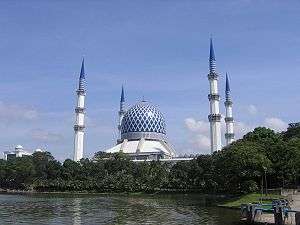
Shah Alam is most famous for its mosque, the Sultan Salahuddin Abdul Aziz Mosque. It is also known as the Blue Mosque and has been claimed to be the largest mosque in Malaysia, and one of the largest in Southeast Asia. The mosque has the capacity to accommodate 24,000 worshippers at one time. Its distinguishing feature is its large blue and silver dome, which measures 51.2 m (167 ft) in diameter and reaches 106.7 m (350 ft) above ground level. The mosque has four minarets erected at the corners, each minaret is 142.3 m (460 ft) tall. The mosque was commissioned by the late Sultan Salahuddin Abdul Aziz when he declared Shah Alam as the new capital of Selangor on 14 February 1974. Construction of the mosque was completed on 11 March 1988. As the capital of Selangor, Islam is the religion preferred by a majority of Shah Alam residents.[14][15]
Tourism

Garden of Islamic Arts
The Blue Mosque overlooks the Garden of Islamic Arts, a landscaped park inspired by the Quranic Garden of Paradise. This 14 hectares of spiritual sanctuary houses nine galleries exhibiting a rich array of Islamic arts such as calligraphy, sculptures, paintings and architecture. The site is occasionally used for traditional Islamic performances.[16]
Sultan Alam Shah Museum (Selangor State Museum)
The Selangor State Museum (Sultan Alam Shah Museum) displays many treasures and artefacts related to the history of Selangor. Adjacent to the museum is the former Selangor State Library (Perpustakaan Raja Tun Uda). The Selangor Islamic Arts Complex (Kompleks Kesenian Islam Selangor or Riyadh Fannil Islam) is situated nearby, housing many Islamic masterpieces and creativities such as a variety of Islamic calligraphy, known as khat, and a number of precious treasures. An Islamic Art College is located within the Complex. At the banks of the Lake Gardens, an art gallery and performance centre called Laman Budaya is located, where exhibitions and shows regularly take place.
The city is surrounded by many parks and gardens, such as the Shah Alam Lake Gardens (developed around seven artificial lakes), the Bukit Cahaya Sri Alam Agricultural Park (soon to be National Botanical Gardens) and the Alam Megah Recreational Park, situated in Section 28.
Sports

Shah Alam has a fully equipped sports complex known as Kompleks Sukan Shah Alam or Shah Alam Sports Complex.
Among the facilities located within the Complex is the gigantic Stadium Shah Alam or Shah Alam Stadium. Shah Alam Stadium is the home of Selangor FC. Shah Alam Stadium was the biggest stadium in Malaysia with 80,000 seats prior to the construction of the National Stadium, Bukit Jalil which could accommodate up to 100,000 spectators. Shah Alam Stadium was featured in a challenge in the first leg of The Amazing Race Asia Season 1 where teams had to ride go-karts around the circuit.
Apart from Stadium Shah Alam, there is Stadium Melawati or the Melawati Stadium, an indoor stadium that could accommodate 40,000 people in one time. Besides sports matches, this stadium had been used for several occasions such as the final concert of Akademi Fantasia and the Perhimpunan Pekerja 2008 held by the Dewan Pemuda PAS. The grandest occasion ever held in this stadium was the boxing finals of the 1998 Commonwealth Games which saw Malaysian Sapok Biki winning a gold medal.
The Shah Alam Sports Complex also includes the Pusat Akuatik Darul Ehsan or the Darul Ehsan Aquatic Centre, a Go-Kart track located within the Stadium Shah Alam parking compound, as well as the Shah Alam Extreme Park located in Section 13.
Shah Alam hosted 2 events for the 1998 Commonwealth Games, road cycling and boxing.
Recreation

Uptown Shah Alam
Uptown Shah Alam is located in Section 24 near the LKSA highway. It is a very popular place for locals where it is more than just a flea market. There are food stalls and events such as concert and games every now and then.[17]
Bon Odori

Bon Odori (meaning simply Bon dance) is a yearly event held during Obon. It is celebrated as Japanese Buddhist custom to honour the departed (deceased) spirits of one's ancestors. In Malaysia, Bon Odori Festivals are also celebrated in a smaller scale every year in Penang and at the Panasonic Sports Complex in Section 21, Shah Alam, Selangor. Held mainly to expose locals to a part of Japanese culture, the festival provides the experience of a variety of Japanese food & drinks, art and dance. Celebration in Malaysia is more towards culture compared to of religion. Admission is free and this event is organised by The Japan Club of Kuala Lumpur, The Japanese School of Kuala Lumpur and The Embassy of Japan.
Wet World
Wet World is known as Malaysia's largest water theme park chain. It has three venues in Malaysia, strategically located at Wet World Shah Alam, Selangor; Wet World Batu Pahat, Johor; and Wet World Air Panas, Pedas, Negeri Sembilan.
International relations
Sister cities
Shah Alam currently has two sister cities:
See also
Notes and references
- 1 2 "Mission to ensure excellence". New Straits Times. 10 October 2000.
- 1 2 "Official Portal of Shah Alam City Council – History". mbsa.gov.my. 24 June 2011. Retrieved 24 July 2011.
- ↑ "City Declaration". mbsa.gov.my. 11 October 2010. Retrieved 24 July 2011.
- ↑ "Abu Sujak made the first mayor". New Straits Times. 10 October 2000.
- ↑ "Monthly Averages for Klang, Malaysia". Weather.com. Retrieved 10 November 2011.
- ↑ "MBSA: Sejarah". 11 August 2010. Retrieved 11 November 2011.
- ↑ Home page. Rayani Air. Retrieved on 10 January 2016. "Rayani Air Sdn. Bhd. No.22-1A Blok 2, Jalan Pahat G-15G Dataran Otomobil Seksyen 15 40200 Shah Alam, Selangor"
- ↑ 吉隆坡臺灣學校. Cts.edu.my. Retrieved on 27 September 2013.
- ↑ "Utiliti: Stesen Komuter – Majlis Bandaraya Shah Alam". 10 November 2010. Retrieved 14 November 2011.
- ↑ "Utiliti: Bas – Majlis Bandaraya Shah Alam". 10 November 2010. Retrieved 14 November 2011.
- ↑ "Shah Alam Hospital finally opens after 4-year delay". Retrieved 7 November 2015.
- ↑ "Shah Alam Hospital to open in Sept". Retrieved 7 November 2015.
- ↑ "Population Distribution by Local Authority Areas and Mukims, 2010" (PDF). Department of Statistics Malaysia.
- ↑ "Tourism Malaysia-Selangor destinations-Blue Mosque". Government website-Tourism Malaysia. 2011. Retrieved 26 January 2011.
- ↑ "Blue Mosque (Sultan Salahuddin Abdul Aziz Shah Mosque)". Malaysian Ministry of Tourism-VirtualMalaysia.com. 2011. Retrieved 26 January 2011.
- ↑ Malaysian Government (2011). "Tourism Malaysia-Selangor destinations-Blue Mosque". Tourism Malaysia. Government. Retrieved 26 January 2011.
- ↑ http://www.uptownshahalam.com.my/
- ↑ Gina Puspitasari Rochman; Delik Hudalah (July 2013). "Evaluasi Keberhasilan Kerjasama Antar Kota 'Sister City' Kota Surabaya" (PDF). Program Studi Sarjana Perencanaan Wilayah dan Kota (in Indonesian). Sekolah Arsitektur Perencanaan dan Pengembangan Kebijakan, ITB. Archived (PDF) from the original on 21 December 2015. Retrieved 21 December 2015.
- ↑ Yvonne T. Nathan (3 December 2013). "Shah Alam signs pact with South Korean city of Hanam". The Star. Retrieved 21 December 2015.
External links
| Wikimedia Commons has media related to Shah Alam. |
- Tourism Malaysia-Selangor
-
 Shah Alam travel guide from Wikivoyage
| Preceded by Klang |
Capital of Selangor (1978–present) |
Succeeded by present |
Coordinates: 3°05′N 101°32′E / 3.083°N 101.533°E