Sha Tin Airfield
| Shatin Airfield RAF Shatin | |||||||||||
|---|---|---|---|---|---|---|---|---|---|---|---|
|
Runway of Sha Tin Airfield (highlighted in yellow) | |||||||||||
| IATA: N/A – ICAO: VHST | |||||||||||
| Summary | |||||||||||
| Airport type | Military, Defunct | ||||||||||
| Owner | RAF, Army Air Corps | ||||||||||
| Operator | RAF, Army Air Corps | ||||||||||
| Serves | Shatin, New Territories | ||||||||||
| Location | Sha Tin | ||||||||||
| Elevation AMSL | 26 ft / 8 m | ||||||||||
| Coordinates | 22°22′49″N 114°11′23″E / 22.38024°N 114.18983°ECoordinates: 22°22′49″N 114°11′23″E / 22.38024°N 114.18983°E | ||||||||||
| Runways | |||||||||||
| |||||||||||
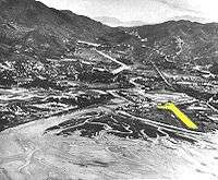
Sha Tin Airfield was a small military airfield in Sha Tin, New Territories, Hong Kong, which had a single concrete runway. The airfield was located along the Shing Mun River and looked out to Tide Cove. The airfield served as a Flight (military unit) based for most of the location's existence.
The airfield was demolished in the early 1970s as the RAF consolidated their operations at RAF Shek Kong and later re-developed as part of the New Town project for Shatin.
History
In 1949, Sha Tin Airfield was built for use by the Royal Air Force (as RAF Shatin). The designation as an RAF airfield was brief and was transferred to the British Army's Army Air Corps (AAC). In the 1950s and 1960, the AAC rotated in various Air Observation Post Flight units from Britain to Hong Kong:
- No. 20 Independent Reconnaissance Flight
- 1900 Air Observation Post Flight
- 1903 Air Observation Post Flight
- 7 Flight AAC
- 8 Flight AAC
- 12 Flight AAC
- 16 Flight AAC
- 25 Flight AAC
- 29 Flight AAC
The Air Observation Post were under the command of the 40th Infantry Division.
The base operated the Auster AOP.6, an aircraft also used by the Royal Hong Kong Auxiliary Air Force.
In 1962, Typhoon Wanda severely damaged much of the site and moved to Kai Tak airport to relocate with the RAF around 1963. Subsequently, the base was demolished in the early 1970s to make way for developing the Sha Tin New Town.
During the late 1950s a private club used the airfield to fly RC model airplanes.[1] The club remained at the airfield until 1970.
Prior to 1949, the area was used briefly as an airfield. Belgian pilot Charles den Bron flew his Spirit of Shatin from an airfield in the area in 1911.
Geography
It was located near the Sha Tin Station of the Kowloon-Canton Railway British Section, near present-day Hong Kong Heritage Museum and Royal Park Hotel. The airfield was built on the shallow shores of Tide Cove.
Facilities
The airfield consisted of a single 600-metre runway, direction 05/23. Facilities at the airfield consisted of a small control tower, building and hangars made of corrugated steel sections. The airfield was abandoned after Typhoon Wanda in 1962. All the structures were demolished when the base closed in the 1970s. The Air Observation Post Headquarter's building was located at the edge of the Tide Cove facing Tolo Harbour.
The runway is now the location of the Hong Kong Heritage Museum, New Town Plaza Phase 3 and Royal Park Hotel, while the base would be where Sha Tin Park is now located.
See also
- Military of Hong Kong
- British Forces Overseas Hong Kong
- Sek Kong Airfield
- RAF Kai Tak
- Aviation history of Hong Kong
References
- 宋軒麟 (2004), 《香港航空百年》, Hong Kong: Joint Us Press (ISBN 962-04-2188-4)
- http://www.flightglobal.com/pdfarchive/view/1957/1957%20-%201449.html
- http://www.flightglobal.com/pdfarchive/view/1961/1961%20-%200922.html
- http://www.flightglobal.com/pdfarchive/view/1954/1954%20-%201569.html