Sestra River (Leningrad Oblast)
| Sestra Сестра Rajajoki | |
|---|---|
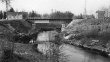
 The railway bridge over the Sestra in Beloostrov | |
| Country | Russia |
| Basin | |
| River mouth | Gulf of Finland |
| Basin size | 399 km2 (154 sq mi)[1] |
| Physical characteristics | |
| Length | 74 km (46 mi)[1] |

The Sestra (Russian: Сестра; Finnish: Rajajoki or Siestarjoki; Swedish: Systerbäck) is a river in Vsevolozhsky and Vyborgsky Districts of Leningrad Oblast and Kurortny District of Saint Petersburg, Russia. The length of the Sestra is 74 kilometres (46 mi), and the area of its basin is 399 square kilometres (154 sq mi).[1]
The Sestra River flows over the Karelian Isthmus. The source of the river is in swamps west of the settlement of Vaskelovo, and the Sestra flows in the general direction south, having its mouth in the town of Sestroretsk. It used to fall into the Gulf of Finland until the early 18th century. After the construction of a dam for the needs of the munitions factory in Sestroretsk, a part of the river was turned into a reservoir called Sestroretsky Razliv (Sestroretsk Overflow), 2 metres (7 ft) deep with an area of 10.6 square kilometres (4.1 sq mi). Since then, the Sestra River has been flowing into this reservoir. The Sestroretsk Overflow is separated from the Gulf of Finland with a ridge of artificial sand dunes. Excess water is dumped into the Gulf of Finland through a canal, which is 4.8 kilometres (3.0 mi) long.
The Sestra River served as a natural border between Russia and Sweden (1323–1617) and between Russia and Finland (1812–1940). It currently serves as a border between Vsevolozhsky (east, formerly Soviet Union) and Vyborgsky (west, formerly Finland) districts of Leningrad Oblast.
References
![]() Media related to Sestra River at Wikimedia Commons
Media related to Sestra River at Wikimedia Commons
- 1 2 3 Река Сестра (Рая-Йоки) (in Russian). State Water Register of Russia. Retrieved 4 June 2013.
Rivers and canals of Saint Petersburg | ||
|---|---|---|
|  | |
Coordinates: 60°21′33″N 30°04′24″E / 60.35917°N 30.07333°E