Serra da Capivara National Park
| Serra da Capivara National Park | |
|---|---|
|
IUCN category II (national park) | |
 | |
 Location of Serra da Capivara National Park | |
| Location | Piauí, Brazil |
| Coordinates | 8°40′S 42°33′W / 8.667°S 42.550°WCoordinates: 8°40′S 42°33′W / 8.667°S 42.550°W |
| Area | 1,291.4 km2 (319,100 acres) |
| Type | Cultural |
| Criteria | iii |
| Designated | 1991 (15th session) |
| Reference no. | 606 |
| Region | Latin America and the Caribbean |
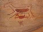
Serra da Capivara National Park (Portuguese: Parque Nacional Serra da Capivara, IPA: [ˈpaʁki nɐsjoˈnaw ˈsɛʁɐ ðɐ kɐpiˈvaɾɐ], locally [ˈsɛɦɐ da kapiˈvaɾɐ]) is a national park in the Northeastern region of Brazil. The area has many prehistoric paintings.
Location
It is located in northeast state of Piauí, between latitudes 8° 26' 50" and 8° 54' 23" south and longitudes 42° 19' 47" and 42° 45' 51" west. It falls within the municipal areas of São Raimundo Nonato, São João do Piauí, Coronel José Dias and Canto do Buriti. It has an area of 1291.4 square kilometres (319,000 acres).
The Capivara-Confusões Ecological Corridor, created in 2006, links the park to the Serra das Confusões National Park.[1]
History
The park was created to protect the prehistoric artifacts and paintings found there. It became a World Heritage Site in 1991. Its head archaeologist is Niède Guidon. Its best known archaeological site is Pedra Furada.
This area has the largest concentration of prehistoric sites in the Americas. Scientific studies confirm that the Capivara mountain range was densely populated in the pre-Columbian Era.[2]
A newer site is Toca da Tira Peia, where the stone tools found may date to as early as 22,000 years ago. The site has been dated through optically stimulated luminescence.[3]
Other important archaeological sites in the area are Toca da Pena, Baxao da Esperanca, and Sitio do Meio. Lapa do Boquete site is located directly south.[4]
Sitio do Meio
Sitio do Meio is the second most important rock shelter in the area after Pedra Furada. It features fully Pleistocene dates and artefacts. The stone artefacts are better preserved because of the absence of waterfalls here. At least 98 stone tools seem older than 12,500 BP. They belong to the Upper Pleistocenic phase of Pedra Furada 3.[5]


See also
References
- ↑ Serras da Capivara e das Confusões serão unidas por corredor ecológico (in Portuguese), MMA, 11 March 2005, retrieved 2016-11-04
- ↑ Romero, Simon (March 27, 2014). "Discoveries Challenge Beliefs on Humans' Arrival in the Americas". New York Times. Retrieved May 31, 2014.
- ↑ Lahaye, Christelle; Hernandez, Marion; Boëda, Eric; Felice, Gisele D.; Guidon, Niède; Hoeltz, Sirlei; Lourdeau, Antoine; Pagli, Marina; Pessis, Anne-Marie; Rasse, Michel; Viana, Sibeli (2013). "Human occupation in South America by 20,000 BC: the Toca da Tira Peia site, Piauí, Brazil". Journal of Archaeological Science. 40 (6): 2840–2847. doi:10.1016/j.jas.2013.02.019. ISSN 0305-4403.
- ↑ German Dziebel, THE TOCA DA TIRA PEIA SITE AND THE END OF AN ICE AGE IN AMERICAN ARCHAEOLOGY. Anthropogenesis, April 24, 2013 (see map)
- ↑ AIMOLA, Giulia et al. Final Pleistocene and Early Holocene at Sitio do Meio, Piauí, Brazil: Stratigraphy and comparison with Pedra Furada. Journal of Lithic Studies, [S.l.], v. 1, n. 2, p. 5-24, sep. 2014. ISSN 2055-0472. Available at: <http://journals.ed.ac.uk/lithicstudies/article/view/1125/1631>. Date accessed: 16 Apr. 2016 doi:10.2218/jls.v1i2.1125
Bibliography
- Eric Boëda, et al. (2014), Les Industries pléistocènes du Piaui. Nouvelles données academia.edu
External links
| Wikimedia Commons has media related to Serra da Capivara National Park. |
- The Rock Art of Serra da Capivara
- Brazilian Ministry of External Relations information about park
- Photos of Serra da Capivara by Maria-Brazil
- FUMDHAM - South-American Pre-Historic Men Foundation
World Heritage Sites in Brazil | ||
|---|---|---|
| North Region |   | |
| Northeast Region |
| |
| Central-West Region |
| |
| Southeast Region |
| |
| South Region |
| |