Serock
| Serock | |||
|---|---|---|---|
|
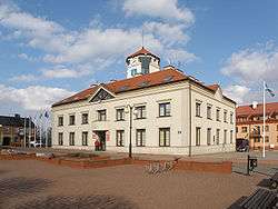
Town hall | |||
| |||
 Serock | |||
| Coordinates: 52°30′47″N 21°4′10″E / 52.51306°N 21.06944°E | |||
| Country |
| ||
| Voivodeship | Masovian | ||
| County | Legionowo | ||
| Gmina | Serock | ||
| Established | 11th century | ||
| Town rights | 1417, 1923 | ||
| Government | |||
| • Mayor | Sylwester Edwin Sokolnicki | ||
| Area | |||
| • Total | 12.48 km2 (4.82 sq mi) | ||
| Elevation | 110 m (360 ft) | ||
| Population (2006) | |||
| • Total | 3,721 | ||
| • Density | 300/km2 (770/sq mi) | ||
| Time zone | CET (UTC+1) | ||
| • Summer (DST) | CEST (UTC+2) | ||
| Postal code | 05-140 | ||
| Area code(s) | +48 22 | ||
| Car plates | WL | ||
| Website | http://www.serock.pl | ||


Serock [ˈsɛrɔt͡sk] is a town at the north bank of the Zegrze lake in the Legionowo County, Masovian Voivodeship, Poland, around 40 kilometres (25 miles) north of Warsaw. It has 4,109 inhabitants (2013).
History
The first mention of the village dates from 1065 with the so-called "Falsyfikat mogileński" a document from the Benedictine monastery in Mogilno. The town is situated on the route which was the trade route leading from Gdańsk and Truso to Rus'.
Serock It showed also in a list from 1113-1124, where it was mentioned as one of the most important princely castles of Mazovia, which operated a river crossing (the Bug and Narew rivers intersect beside Serock) with a customs house.
From 1417, Serock was granted city rights under Chełmno law by Janusz I of Warsaw. By then it was already a craft and commercial center. From this period the urban layout was created in the form of the market square and the late Gothic church of the parish.
In the 15th and 17th century municipal courts were held there. From 1655-1660, during the Swedish invasion, the city was largely destroyed. From 1795, it was in the Prussian partition, from 1807 it came under the possession of the Duchy of Warsaw, and from 1815 it was under Russian rule.
Serock repeatedly was on the battle lines on the outskirts of Warsaw, including in 1794, 1809 and 1831. In 1806, on the orders of Napoleon I fortifications were built in Serock. From 1807 it was a fortress. During the Polish–Austrian war in 1809, it was the operational location of General Józef Niemojewski's troops. Then the fortress was expanded (at the initiative of the French Marshal Davout) until 1811, when it gained greater importance than Modlin Fortress. In 1831 the Polish army formed in Serock (during the November Uprising).
In 1870, the city was deprived of city rights. They were recovered in 1923.
In September 1939, was a place of fighting during the Invasion of Poland, and again in 1944 and 1945, between the Soviets and the Germans.
In December 5, 1939, around 3,000 Jews were deported from the city by the Germans. From 1940-1944 there was a forced labor camp there, and in 1942 the ghetto contained around two thousand people.
During World War II, Serock was in the Third Reich, the boundary between the Third Reich and the General Government proceeded along the Narew river. In November and December, 1944 the Eastern Front ran through the town. Germany defended from Serock across the Narew against the Red Army. The Russians launched a massive Katyusha rocket launcher attack resulting in Serock's destruction. After the war it was rebuilt.
Today there are no Jews. In the summer of 2000, a visiting descendant of former residents discovered that a number of gravestones (matzevot) were piled up in the city park.[1] The stones had been gathered by a non-Jewish resident who roped off the area. In 2006, a visit by members of the Jewish Records Indexing-Poland project confirmed this and an attempt is under way to establish a memorial on the site of the former Jewish cemetery. The United States Commission for the Preservation of America's Heritage Abroad is involved in the project.[2]
The model settlement Barbarka

An early medieval settlement called Ogrodziskiem or Barbarką was located on the right bank of the Narew river, near the mouth of the Bug river. Its development was from the 11th to 13th centuries. It represents one of the oldest castles in Mazovia.
The settlement was located on two trade and communication routes:
- To Rus: Nur, Brok, and Brańsk to Wielkopolska, Kujawy and Pomerania;
- From southern Poland to Jaćwieży and Prussia.
During the tests conducted in 1961 by Prof. Dr. Zdzisław Rajewski, pieces of pottery, pugging (flooring) and parts of animal bones were found.
Excavations carried out from 1962 to 1966 by Barbarę Zawadzką-Antosik showed three stages of the early settlement and human functioning in these areas in the 14th and 17th centuries. They also located the cemetery and a nave chapel with apse.
Approximately 200 archaeological sites were excavated consisting of, among others, fragments of pottery, animal bones and the remains of fish. They showed that the people mainly engaged in agriculture (cultivated wheat, rye, peas), fishing, weaving and craft work.
Church of the Annunciation of the Blessed Virgin Mary

The brick, one-nave church of the Annunciation of the Blessed Virgin Mary (Kościół Zwiastowania Najświętszej Maryi Panny) - formerly St. Adalbert's (św. Wojciecha) - was founded by the dukes of Mazovia: Janusz III and Stanislaus. The initiator was a Serock pastor Wojciech Popielski of Popielżyna. The church was built between the first quarter and the end of the 16th century. In the 3rd quarter of the 18th century, the window was rebuilt. It has been restored many times, notably from 1934 to 1938.
The church has a floor positioned below the level of the environment, a simple closed chancel, two symmetrically placed vestries, a three-bay nave, and a tower. It was built on a thread cross. The vaults of the nave barrel vault with lunettes of the star superimposed on grid ribs. On the eastern slope is the inscription IH1586 .
There is a picture showing Stanislas Witold Bienias Battle of Warsaw in 1920 as well as original baroque items such as:
- the main altar, which shows the Annunciation of the Blessed Virgin Mary
- sculptures of St. Adalbert and St. Stanislaus
- side altar of St. Anne
- side altar of St. Barbara
- a font
In 1961, the church was entered in the Polish register of monuments.
Industry
In Serock there are small service and manufacturing industries. Goods manufactured here are mainly food, electrical engineering, ceramics, furniture and equipment. Around the village, strawberries and vegetables are grown.
Tourism
Serock is a recreational and relaxation site. Holiday resorts and conference and training centres are located here or nearby. There is also a haven for passenger shipping. There are numerous organised hiking trails, including the road brook and ravine at the top of the Barbarka. Through the village runs the tourist walking trail with Dębego. As a result of the damming of the Bug and Narew rivers, conditions are ideal for water sports and fishing. There are approximately 4,500 recreational homes in the area.
The location is also a center of culture and sport. There's a lot of organised cultural events, including the International Folklore Review Kupalnocka (including experienced teams from Taiwan, Russia, Lithuania, Bulgaria, Chile, Romania, Slovakia, Sweden, Greece, Egypt, Italy, France, Turkey, Canada, Croatia, and the Netherlands) and Serock Summer Music (including vocal and instrumental concerts at the top of Barbarka).
Communication
Serock is at an intersection of national roads 61 and 62 which has bus connections but no railway connections.
Twin towns – Sister cities
Gallery
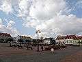 The market in Serock
 The church in Serock
 The church in Serock
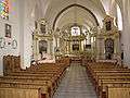 Interior of the church
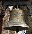 Jubilee Bell (AD 2000)
References
External links
| Wikimedia Commons has media related to Serock. |
- http://www.serock.pl/
- Jewish Community in Serock on Virtual Shtetl
Coordinates: 52°30′47″N 21°04′10″E / 52.51306°N 21.06944°E