Sepik
| Sepik | |
| River | |
 Sediment plumes at the mouth of the Sepik (right) and Ramu (left) rivers | |
| Countries | Papua New Guinea, Indonesia |
|---|---|
| Regions | Sandaun, Papua, East Sepik |
| Tributaries | |
| - left | Yellow River |
| - right | April River, Karawari, Yuat, Keram |
| Source | |
| - location | Victor Emanuel Range, Papua New Guinea |
| - elevation | 2,170 m (7,119 ft) |
| - coordinates | 5°13′S 141°49′E / 5.217°S 141.817°E |
| Mouth | |
| - location | Bismarck Sea, Papua New Guinea |
| - elevation | 0 m (0 ft) |
| - coordinates | 3°50′30″S 144°32′30″E / 3.84167°S 144.54167°ECoordinates: 3°50′30″S 144°32′30″E / 3.84167°S 144.54167°E |
| Length | 1,126 km (700 mi) |
| Basin | 80,321 km2 (31,012 sq mi) [1] |
| Discharge | |
| - average | 3,804 m3/s (134,337 cu ft/s) |
 The location of the Sepik River | |
The Sepik River (/ˈseɪpɪk/) is the longest river on the island of New Guinea, and after the Fly and the Mamberamo the third largest by volume.[2] The majority of the river flows through the Papua New Guinea (PNG) provinces of Sandaun and East Sepik, with a small section flowing through the Indonesian province of Papua.
The Sepik has a large catchment area, and landforms that include swamplands, tropical rainforests and mountains. Biologically, the river system is possibly the largest uncontaminated freshwater wetland system in the Asia-Pacific region.[3]
The Sepik was named Kaiserin Augusta River by the German colonial explorer Otto Finsch, after the German Empress Augusta.
Description
The river originates in the Victor Emanuel Range in the central highlands of Papua New Guinea. From its mountain headwaters near Telefomin, it travels north-west and leaves the mountains abruptly near Yapsei. From here it flows into Indonesian Papua, before turning back north-east for the majority of its journey following the Great Depression. Along its course it receives numerous tributaries from the Bewani and Torricelli Mountains to the north and the Central Range to the south.
For most of the Sepik's length the river winds in serpentine fashion, like the Amazon River, to the Bismarck Sea off northern Papua New Guinea. Unlike many other large rivers, the Sepik has no delta whatsoever, but flows straight into the sea, about 100 kilometres (60 mi) east of the town of Wewak. It is also navigable for most of its length.
The river's total length is 1,126 kilometres (700 mi) and has a drainage basin of over 80,000 km² (30,000 mi²).[1] There is a 5-10 kilometres wide belt of active meanders formed by the river along most of its course that has created a floodplain up to 70 kilometres wide with extensive backwater swamps.[3] There are around 1,500 Oxbow and other lakes in the floodplain, the largest of which are the Chambri Lakes.[3]
The Sepik basin is largely an undisturbed environment, as there are no major urban settlements or mining and forestry activities in the river catchment.
History
Local villagers have lived along the river for many millennia and the river has formed the basis for food, transport and culture.
Exploration
European contact with the river started in 1885 when the Germans as part of establishing German New Guinea explored the area. The river was named by Dr Otto Finsch, Kaiserin Augusta, after the German Empress Augusta.[4] Upon finding the river, Finsch navigated about 50 kilometres (31 mi) upstream from its mouth.[4]
In 1886 and 1887, further expeditions by steam boat were conducted by the Germans and over 600 kilometres (370 mi) were explored.[4] Between 1912 and 1913 the Germans sent further expeditions to explore the river and surrounding areas. They collected flora and fauna, studied local tribes and produced the first maps. The station town of Angoram was established as a base on the lower Sepik for explorations, but with the beginning of World War I, the explorations ceased.[4]
After the first World War the Australian government took trusteeship of the German colony, creating the Territory of New Guinea, and the Sepik region came under their jurisdiction. During this period the Australians established a station on the middle Sepik at Ambunti to conduct further explorations.[4]
In 1923 journalist Beatrice Grimshaw attached herself to an expedition, and claimed to be the first white woman to ascent the Sepik, commenting on the widespread use of "Tok Pisinpidgen-English" as a lingua franca.[5] In 1935 Sir Walter McNicoll's the new administrator of the Territory of New Guinea travelled up length of the Sepik to "have a look at the river people and the kind of country along the banks".[6]
In 2010 Clark Carter and Andrew Johnson travelled the length of the Sepik River from source to sea. They hiked to the source from Telefomin and kayaked down the upper reaches in an inflatable kayak. After nearly drowning in a section of rapids near Telefomin, they decided to walk through the jungle, following the river until it was calm enough to take a dugout canoe the remaining 900 kilometres to the Bismarck Sea. The expedition took six weeks.
World War II
The Japanese held the area throughout most of the Second World War. By the end of the war though, the Japanese had been completely surrounded after Hollandia in Netherlands New Guinea was captured in April 1944 during Operations Reckless and Persecution and Aitape had fallen during the campaign in August 1944. The battle to defeat the remaining forces by the Australian Army was hard fought and drawn out due to the terrain.
The Australians eventually pushed the Japanese back to the village of Timbunke on the middle Sepik in July 1945. After an Australian RAAF plane landed 10 kilometres (6 mi) from Timbunke the Japanese suspected that the villagers had collaborated with the Australians and proceeded to massacre 100 of the villagers.[7]
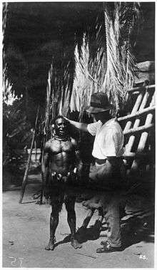
Sepik art
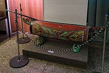
The tribes living along the river produce magnificent wood carvings, clay pottery and other art and craft within the broader traditions of New Guinea art. Many tribes use garamut drums in rituals; the drums are formed from long, hollowed-out tree trunks carved into the shape of various totem animals.[8][9][10]
Image gallery
 Korogo Village, Sepik River, PNG, 1975. Franz Luthi
 A warm welcome to foreign visitors
 Snapshot of the daily life of the villagers
References
- 1 2 "OC05 Sepik". Water Resources eAtlas. Watersheds of the World.
- ↑ Fragmentation and Flow Regulation of the World’s Large River Systems
- 1 2 3 "Sepik River". Rainbow Habitat.
- 1 2 3 4 5 Lipscomb, Adrian; et al. (February 1998). Papua New Guinea (6 ed.). Lonely Planet. pp. 249–252. ISBN 0-86442-402-7.
- ↑ Hoehn, Matthew, ed., 1948, Catholic Authors Contemporary Biographical Sketches, 1930-1947: Newark, NJ, St. Marys Abbey, p. 293-295, cited on "Grimshaw Origin" accessed 6 August 2016
- ↑ McCarthy, J.K. (1963). Patrol into yesterday. Melbourne: F.W Cheshire Pty Ltd. pp. 139–149. ISBN 0-7015-0327-0.
- ↑ "Chapter Seven: Voices from Asia and the Pacific". War Compensation Forum.
- ↑ "Amazon.com listing for the "Four Corners: A Journey into the Heart of Papua New Guinea"".
- ↑ Salak, Kira. "Nonfiction book about Papua New Guinea,"Four Corners"".
- ↑ Salak, Kira. "Includes photos of Art of Sepik River, Papua New Guinea".
External links
- The Sepik–Ramu System
- http://www.pacificislandtravel.com/png/about_destin/sepik.html
- http://www.art-pacific.com/artifacts/nuguinea/sepikriv/sepikmrv.htm
- http://www.ewaoceanicgallery.com/sepik_river_region.html
- A Report on the Sepik River Basin
- Papua New Guinea Sepik River Video
- The Sepik River Expedition 2010
Major rivers of Papua New Guinea | ||
|---|---|---|