Semien Mountains
.jpg)
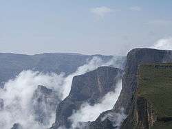
The Semien Mountains (in Amharic ስሜን or Səmen; also spelled Simien and Simen), in northern Ethiopia, north east of Gondar, are part of the Ethiopian Highlands. They are a World Heritage Site and include the Semien Mountains National Park. The mountains consist of plateaux separated by valleys and rising to pinnacles. The tallest peak is Ras Dashen (4,550 m); other notable heights include Mounts Biuat (4,437 m) and Kidis Yared (4,453 m).
Because of their geological origins the mountains are almost unique, with only South Africa's Drakensberg having been formed in the same manner and thus appearing similar. Notable animals in the mountains include the walia ibex, gelada, and caracal. There are a few Ethiopian wolves.
Human history
Although the word Semien means "north" in Amharic, according to Richard Pankhurst the ancestral form of the word actually meant "south" in Ge'ez, because the mountains lay to the south of Aksum, which was at the time the center of Ethiopian civilization. But as over the following centuries the center of Ethiopian civilization itself moved to the south, these mountains came to be thought of as lying to the north, and the meaning of the word likewise changed.[1]
The Semiens are remarkable as being one of the few spots in Africa where snow regularly falls.[2] First mentioned in the Monumentum Adulitanum of the 4th century AD (which described them as "inaccessible mountains covered with snow" and where soldiers walked up to their knees in snow), the presence of snow was undeniably witnessed by the 17th century Jesuit priest Jerónimo Lobo.[3] Although the later traveler James Bruce claims that he had never witnessed snow in the Semien Mountains, the 19th century explorer Henry Salt not only recorded that he saw snow there (on 9 April 1814), but explained the reason for Bruce's failure to see snow in these mountains – Bruce had ventured no further than the foothills into the Semiens.[4]
Despite their ruggedness and altitude, the mountains are dotted with villages linked by tracks. Historically they were inhabited by Ethiopian Jews (the Beta Israel), who after repeated attacks by the zealous Christian Emperors in the 15th century withdrew from the province of Dembiya into the more defensible Semien mountains.[5]
Towards the end of the Zemene Mesafint, Dejazmach Wube Haile Mariam maintained his arsenal and treasury on Mount Hai.[6]
Gallery
-

-
-

Waterfall in Semien Mountains, falling into the Gishe Abbai, near Debarq.
-

A gelada in the Semien Mountains
References
- ↑ "Historical Notes on Books: An Early Ethiopian Map" (Capital newspaper website)
- ↑ Discussed further in Frederick J. Simoons, "Snow in Ethiopia: A Review of the Evidence", Geographical Review, 50 (1960), pp. 402-411.
- ↑ Donald M. Lockhart (translator), The Itinerário of Jerónimo Lobo (London: Hakluyt Society, 1984), p. 240.
- ↑ Henry Salt, A Voyage to Abyssinia and Travels into the Interior of that Country, 1814 (London: Frank Cass, 1967), p. 352.
- ↑ One account of this process is James Quirin, "Caste and Class in Historical North-West Ethiopia: The Beta Israel (Falasha) and Kemant, 1300-1900", Journal of African History, 39 (1998), pp. 195-220
- ↑ Henry A. Stern, Wanderings among the Falashas in Abyssinia (London, 1862), p. 75
External links
Coordinates: 13°29′34″N 38°26′37″E / 13.49278°N 38.44361°E