Seligman, Arizona
| Seligman, Arizona | |
|---|---|
| CDP | |
|
Welcome sign | |
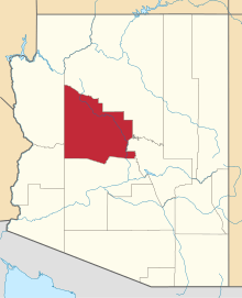
 Location in Yavapai County and the state of Arizona | |
 Seligman, Arizona Location in the United States | |
| Coordinates: 35°19′42″N 112°52′27″W / 35.32833°N 112.87417°WCoordinates: 35°19′42″N 112°52′27″W / 35.32833°N 112.87417°W | |
| Country | United States |
| State | Arizona |
| County | Yavapai |
| Area | |
| • Total | 6.4 sq mi (16.6 km2) |
| • Land | 6.4 sq mi (16.5 km2) |
| • Water | 0.0 sq mi (0.0 km2) |
| Elevation | 5,242 ft (1,598 m) |
| Population (2000) | |
| • Total | 456 |
| • Density | 71.5/sq mi (27.6/km2) |
| Time zone | MST (UTC-7) |
| ZIP code | 86337 |
| Area code(s) | 928 |
| FIPS code | 04-65420 |
| GNIS feature ID | 0011070 |

Seligman (Havasupai: Thavgyalyal[1]) is a census-designated place (CDP) on the northern border of Yavapai County, in northwestern Arizona, the United States.
The population was 456 at the 2000 census.
Geography
Seligman is located at 35°19′42″N 112°52′27″W / 35.32833°N 112.87417°W (35.328199, −112.874303),[2] at 5,240 feet (1,600 m) in elevation, alongside the Big Chino Wash, in a northern section of Chino Valley. The wash is a major tributary of the Verde River. Seligman is a popular stopping point along Historic U.S. Route 66.
According to the United States Census Bureau, the Seligman CDP has a total area of 6.4 square miles (17 km2), all of it land.
History
The region was in the longtime homeland of the Havasupai people, who had a settlement in the present day Seligman area. The town site was on Beale's Wagon Road, and a stage stop on the Mojave Road
Originally Seligman was called “Prescott Junction” because it was the railroad stop on the Santa Fe mainline junction with the Prescott and Arizona Central Railway Company feeder line running to Prescott, in the Arizona Territory. [3] The Atchison, Topeka and Santa Fe Railway had reached it in 1882. [3] In 1886 it was renamed Seligman, after Jesse Seligman, one of the founders of J.W. Seligman Co. of New York, who helped finance the railroad lines in the area. [3] The original feeder line to Prescott was replaced in 1891 by the Santa Fe, Prescott and Phoenix Railway with the Santa Fe mainline junction at Ash Fork instead.
Because of its flat land Seligman became a large switching yard consisting of many tracks, and served as a large livestock shipping center for the areas ranchers. [3] It was also a terminal point for changing train crews between Winslow and Needles, who used overnight cottages in the town. [4]
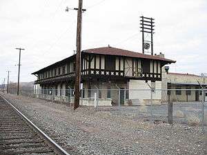
Havasu Harvey House
The 'Havasu House' was a Fred Harvey Company Harvey House hotel and restaurant in Seligman, serving the Santa Fe Railway and local residents. [5][6] It was named “Havasu” after the native Havasupai tribe of the area. [5] Adjacent to it was the Santa Fe Depot and Reading Room. [3] The Havasu Harvey House opened in 1905, closed in 1954, and was demolished in 2008. [5][7]
Passenger trains ceased stopping in Seligman in 1984.[3] The Burlington Northern Santa Fe Railway (BNSF) has owned the tracks through town since 1996, which carries numerous freight trains and nonstop Amtrak trains. [3] The former Santa Fe Reading room, is now located at the Seligman High School. [8]
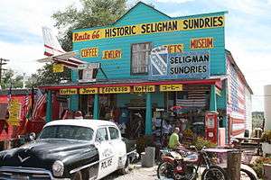
Route 66—Seligman Historic District
The Seligman was on the original U.S. Route 66 from 1926 through 1978, when Interstate 40 bypassed it a couple miles south. [9] [10] Seligman experienced its real heyday after World War II, when returning veterans and other motorists hit the road and made the Southwest a popular tourist destination. [11] The Seligman Commercial Historic District protects the historical central area's early 20th century commercial buildings along Historic Route 66, a revived popular tourist destination. [11] Historic district contributing properties include the include Pitts General Merchandise Store and the U.S. Post Office from 1903, the Pioneer Hall and Theatre and the Seligman Garage from 1905, and the Seligman Pool Hall from 1923. [11]
In 1987 Seligman gained its name “Birthplace of Historic Route 66” due to the efforts of Seligman residents, who convinced the State of Arizona to dedicate Route 66 a historic highway. [12] Seligman is the first stop heading west on the longest uninterrupted stretch of historic Route 66, running around 160 miles (260 km) to Topock on the east side of the Colorado River.[9]
Demographics
As of the census[13] of 2000, there were 456 people, 205 households, and 121 families residing in the CDP. The population density was 71.5 people per square mile (27.6/km²). There were 281 housing units at an average density of 44.0/sq mi (17.0/km²). The racial makeup of the CDP was 85.09% White, 0.22% Black or African American, 1.97% Native American, 1.54% Asian, 0.22% Pacific Islander, 6.14% from other races, and 4.82% from two or more races. Hispanic or Latino of any race were 19.08% of the population.
There were 205 households out of which 29.3% had children under the age of 18 living with them, 44.9% were married couples living together, 10.7% had a female householder with no husband present, and 40.5% were non-families. 36.6% of all households were made up of individuals and 16.6% had someone living alone who was 65 years of age or older. The average household size was 2.22 and the average family size was 2.91.
In the CDP the population was spread out with 26.5% under the age of 18, 5.3% from 18 to 24, 25.4% from 25 to 44, 24.1% from 45 to 64, and 18.6% who were 65 years of age or older. The median age was 41 years. For every 100 females there were 96.6 males. For every 100 females age 18 and over, there were 94.8 males.
The median income for a household in the CDP was US$23,833, and the median income for a family was US$29,722. Males had a median income of US$27,083 versus US$13,594 for females. The per capita income for the CDP was US$11,976. About 14.4% of families and 16.9% of the population were below the poverty line, including 19.2% of those under age 18 and 16.5% of those age 65 or over.
Education
Seligman is within the Seligman Unified School District.
The Seligman High School colors are red, white, and black, and its teams are called the Antelopes. The basketball team won the 1-A state championship in 2006 after consecutive second round exits in the tournament in the two previous years. As well, its baseball team has lost in the final game of the state championship for three straight years.
In culture
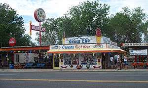
John Lasseter has said in interviews that the town of Radiator Springs in the Pixar film Cars is loosely based on Seligman.[14] While researching the history of Route 66, Lasseter met Seligman barber Angel Delgadillo, who told him how traffic through the town virtually disappeared on the day that nearby Interstate 40 opened.[15]
Delgadillo's brother Juan opened Delgadillo's Snow Cap Drive-In in 1953; the eatery has since become a famous roadside attraction. Author, Route 66 historian and Cars voice actor Michael Wallis covers the history of the restaurant in his book, Route 66: The Mother Road.
Climate
| Climate data for Seligman, Arizona (1981–2010 normals) | |||||||||||||
|---|---|---|---|---|---|---|---|---|---|---|---|---|---|
| Month | Jan | Feb | Mar | Apr | May | Jun | Jul | Aug | Sep | Oct | Nov | Dec | Year |
| Record high °F (°C) | 79 (26) |
84 (29) |
90 (32) |
92 (33) |
99 (37) |
105 (41) |
110 (43) |
106 (41) |
101 (38) |
93 (34) |
85 (29) |
75 (24) |
110 (43) |
| Average high °F (°C) | 53.0 (11.7) |
56.5 (13.6) |
62.7 (17.1) |
70.1 (21.2) |
79.4 (26.3) |
89.0 (31.7) |
92.6 (33.7) |
90.0 (32.2) |
84.5 (29.2) |
73.9 (23.3) |
61.8 (16.6) |
52.9 (11.6) |
72.2 (22.3) |
| Average low °F (°C) | 23.4 (−4.8) |
25.4 (−3.7) |
28.8 (−1.8) |
33.7 (0.9) |
40.7 (4.8) |
47.9 (8.8) |
56.3 (13.5) |
55.8 (13.2) |
48.2 (9) |
37.6 (3.1) |
28.6 (−1.9) |
22.6 (−5.2) |
37.4 (3) |
| Record low °F (°C) | −18 (−28) |
−12 (−24) |
−5 (−21) |
10 (−12) |
14 (−10) |
26 (−3) |
33 (1) |
34 (1) |
26 (−3) |
12 (−11) |
−5 (−21) |
−17 (−27) |
−18 (−28) |
| Average precipitation inches (mm) | 1.17 (29.7) |
1.15 (29.2) |
1.09 (27.7) |
.55 (14) |
.37 (9.4) |
.29 (7.4) |
1.82 (46.2) |
2.18 (55.4) |
1.40 (35.6) |
1.11 (28.2) |
.88 (22.4) |
.89 (22.6) |
12.91 (327.9) |
| Average snowfall inches (cm) | 3.7 (9.4) |
2.4 (6.1) |
1.2 (3) |
.6 (1.5) |
0 (0) |
0 (0) |
0 (0) |
0 (0) |
0 (0) |
.1 (0.3) |
.8 (2) |
1.9 (4.8) |
10.6 (26.9) |
| Average precipitation days (≥ 0.01 in) | 4.6 | 4.6 | 5.2 | 2.8 | 2.7 | 1.9 | 7.6 | 8.4 | 4.7 | 3.5 | 3.0 | 4.9 | 53.9 |
| Average snowy days (≥ 0.1 in) | 1.6 | 1.1 | .8 | .3 | 0 | 0 | 0 | 0 | 0 | .1 | .4 | 1.4 | 5.7 |
| Source: NOAA (extremes 1904–present)[16] | |||||||||||||
Notable residents
- Commodore Perry Owens — Old West gunfighter and lawman
- Georgie Sicking — legendary western rancher and cowboy poet, born in Seligman in 1921
References
- ↑ Hinton, Leanne (1984). A dictionary of the Havasupai language.
- ↑ "US Gazetteer files: 2010, 2000, and 1990". United States Census Bureau. 2011-02-12. Retrieved 2011-04-23.
- 1 2 3 4 5 6 7 Seligmanhistory.com; History of Seligman, Arizona
- ↑ Sharlot Hall Museum Library & Archives.org: "A day trip to Seligman on the Williamson Valley Road"
- 1 2 3 Seligman Arizona Historical Society: Havasu Harvey House
- ↑ Prescott Daily Courier: "Historical photos of Havasu Harvey House in Seligman" . accessed 31 August 2015.
- ↑ Prescott Daily Courier: Railroad tearing down Seligman Harvey House", 13 April, 2008.
- ↑ Harveyhouses.net: Arizona Harvey Houses
- 1 2 Seligmanhistory.com: Seligman History - Route 66
- ↑ Route66seligmanarizona.com: Seligman and historic Route 66
- 1 2 3 National Park Service: Seligman Historic District on Route 66, A Discover Our Shared Heritage Travel Itinerary; accessed 31 August 2015.
- ↑ Seligman Arizona Historical Society homepage
- ↑ "American FactFinder". United States Census Bureau. Retrieved 2008-01-31.
- ↑ St. Louis Post-Dispatch. Search results. Joe Williams. June 4, 2006. The spirit of 66: In the animated movie 'Cars,' Hollywood remembers when it was not just another highway.
- ↑ Internet Movie Database. The Inspiration for 'Cars'. (2006), with Angel Delgadillo, barber and John Lasseter, director.
- ↑ "NowData - NOAA Online Weather Data". National Oceanic and Atmospheric Administration. Retrieved 2013-07-19.
External links
-
 Seligman travel guide from Wikivoyage
| Wikimedia Commons has media related to Seligman, Arizona. |