Seiland National Park
| Seiland National Park | |
|---|---|
|
IUCN category II (national park) | |
|
| |
| Location | Finnmark, Norway |
| Nearest city | Alta and Hammerfest |
| Coordinates | 70°23′N 23°10′E / 70.383°N 23.167°ECoordinates: 70°23′N 23°10′E / 70.383°N 23.167°E |
| Area | 316 km2 (78,100 acres) |
| Established | 8 December 2006 |
| Governing body | County Governor |
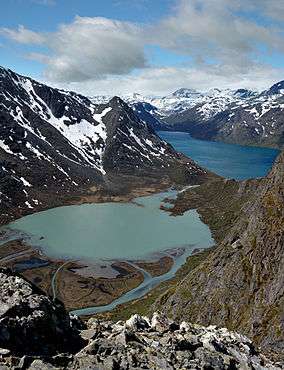
Seiland National Park (Norwegian: Seiland nasjonalpark) lies in the municipalities of Alta, Hammerfest, and Kvalsund in Finnmark county, Norway. The island of Seiland is the second largest in Finnmark county after Sørøya, and the two glaciers on the island, Seilandsjøkelen and Nordmannsjøkelen, are the northernmost glaciers in Scandinavia. The highest point in the park is the 1,078-metre (3,537 ft) tall mountain Seilandstuva. Sea (mostly fjords) constitutes 9.6 square kilometres (3.7 sq mi) of the park's area, including the Nordefjorden, Sørefjorden, and Flaskefjorden.[1]
Name
The name of the island must be very old, from Proto-Norse *Sai-aujo ("sea-island"), and the Northern Sami language name Sievju is probably an old loan and reflection of this form. In Norse times the name was transformed first to *Sæ-ey, and then to just *Sei. The last element land means "land" or "island" is a later addition.
References
- ↑ "Seiland national park" (PDF). Norwegian Directorate for Nature Management. Retrieved 2013-01-16.