Segeberg
| Segeberg | ||
|---|---|---|
| District | ||
| ||
 | ||
| Country |
| |
| State | Schleswig-Holstein | |
| Capital | Bad Segeberg | |
| Area | ||
| • Total | 1,334 km2 (515 sq mi) | |
| Population (31 December 2015)[1] | ||
| • Total | 267,503 | |
| • Density | 200/km2 (520/sq mi) | |
| Time zone | CET (UTC+1) | |
| • Summer (DST) | CEST (UTC+2) | |
| Vehicle registration | SE | |
| Website | kreis-segeberg.de | |
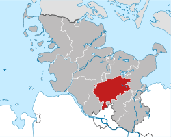
Segeberg is a district in Schleswig-Holstein, Germany. It is bounded by (from the southwest and clockwise) the districts of Pinneberg, Steinburg and Rendsburg-Eckernförde, the city of Neumünster, the districts of Plön, Ostholstein and Stormarn, and the city state of Hamburg.
History
The history of the district is connected with the history of Holstein. In 1134 the castle of Segeberg was erected as a regional centre from where the reeve of Segeberg ruled. When Schleswig-Holstein became a Prussian province in 1865, the Prussian administration established the district of Segeberg.
Since then the district has considerable grown twice: In 1932 parts of the dissolved district of Bordesholm joined the district; and in 1970 the city of Norderstedt became part of the district.
Geography
The district of Segeberg consists of the agricultural plains between the cities of Neumünster and Hamburg. A southwestern portion of the hilly lakeland called "Holsteinische Schweiz" (Holsatian Switzerland) belongs to the district, as well as some northern suburbs of Hamburg.
Coat of arms
 Coat of arms |
The coat of arms displays :
|
Towns and municipalities
| Independent towns and municipalities |
|---|
| Ämter | ||
|---|---|---|
|
|
|
| 1seat of the Amt | ||
References
External links
![]() Media related to Kreis Segeberg at Wikimedia Commons
Media related to Kreis Segeberg at Wikimedia Commons
- Official website (German)
| Urban districts | |
|---|---|
| Rural districts | |
Coordinates: 53°55′N 10°10′E / 53.92°N 10.17°E