Seebenstein
| Seebenstein | ||
|---|---|---|
 | ||
| ||
 Seebenstein Location within Austria | ||
| Coordinates: 47°42′N 16°9′E / 47.700°N 16.150°ECoordinates: 47°42′N 16°9′E / 47.700°N 16.150°E | ||
| Country | Austria | |
| State | Lower Austria | |
| District | Neunkirchen | |
| Government | ||
| • Mayor | Walter Endl | |
| Area | ||
| • Total | 9.09 km2 (3.51 sq mi) | |
| Elevation | 348 m (1,142 ft) | |
| Population (1 January 2016)[1] | ||
| • Total | 1,388 | |
| • Density | 150/km2 (400/sq mi) | |
| Time zone | CET (UTC+1) | |
| • Summer (DST) | CEST (UTC+2) | |
| Postal code | 2824 | |
| Area code | 02627 | |
| Website | www.seebenstein.at | |

Seebenstein is a town in the district of Neunkirchen in the Austrian state of Lower Austria.
Geography
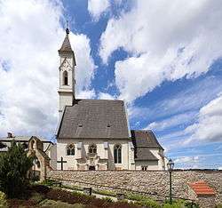
Seebenstein is in the industrial quarter of Lower Austria. The town covers 9.09 square kilometers and is 62.71 percent forested. The town includes the Seebenstein nature park and historic ruin of the Turkensturz. The town is overlooked by Burg Seebenstein.
On 16 April 1972 Seebenstein was the epicenter of a magnitude 5.3 earthquake.
History
In ancient times, Seebenstein was part of the Celtic kingdom of Noricum.
Historical population
| Historical population | ||
|---|---|---|
| Year | Pop. | ±% |
| 1869 | 587 | — |
| 1880 | 700 | +19.3% |
| 1890 | 768 | +9.7% |
| 1900 | 872 | +13.5% |
| 1910 | 979 | +12.3% |
| 1923 | 1,049 | +7.2% |
| 1934 | 952 | −9.2% |
| 1939 | 967 | +1.6% |
| 1951 | 1,075 | +11.2% |
| 1961 | 1,033 | −3.9% |
| 1971 | 1,088 | +5.3% |
| 1981 | 1,040 | −4.4% |
| 1991 | 1,139 | +9.5% |
| 2001 | 1,196 | +5.0% |
| 2011 | 1,326 | +10.9% |
.jpg)
Building from carpark
Demographics
In the 2001 census the population was described as 84.4% Roman Catholic, 3.8% evangelical, 0.5% Muslim, 0.3% Orthodox Christian, and 9.4% with no religion.
References
This article is issued from Wikipedia - version of the 6/9/2016. The text is available under the Creative Commons Attribution/Share Alike but additional terms may apply for the media files.