Sechelt
| Sechelt | |
|---|---|
| District municipality | |
| District of Sechelt[1] | |
| Motto: Blessed by Sun and Seas | |
 | |
| Coordinates: 49°28′27″N 123°45′15″W / 49.47417°N 123.75417°W | |
| Country |
|
| Province |
|
| Region | Sunshine Coast |
| Regional District | Sunshine Coast RD |
| Founded | 1862 (Roman Catholic mission) |
| Incorporated | Feb. 15, 1956 |
| Government | |
| • Mayor | Bruce Milne |
| • Governing body | Sechelt Municipal Council |
| • MLAs | Nicholas Simons, NDP |
| Area | |
| • District municipality | 39.71 km2 (15.33 sq mi) |
| Elevation | 8 m (26 ft) |
| Population (2006) | |
| • District municipality | 8,454 |
| • Density | 212.9/km2 (551/sq mi) |
| • Metro | 27,759 (regional district) |
| Time zone | PST (UTC-8) |
| Postal code span | V0N 3A0 |
| Area code(s) | +1-604 |
| Website | district.sechelt.bc.ca |
Coordinates: 49°28′27″N 123°45′15″W / 49.47417°N 123.75417°W The District Municipality of Sechelt /ˈsiːʃɛlt/ is located on the lower Sunshine Coast of British Columbia. Approximately 50 km northwest of Vancouver, it is accessible from mainland British Columbia by a 40-minute ferry trip between Horseshoe Bay and Langdale, and a 25-minute drive from Langdale along Highway 101, also known as the Sunshine Coast Highway. The name Sechelt means "land between two waters" in the language of the Coast Salish Shishalh people, who first settled the area thousands of years ago.
The original Village of Sechelt was incorporated on February 15, 1956. Sechelt later expanded its boundaries in 1986 with the inclusion of a number of adjacent unincorporated areas. The District of Sechelt, as it is known today, encompasses some 39.71 km² (15.33 sq mi) at the isthmus of the Sechelt Peninsula, between the southern tip of Sechelt Inlet (Porpoise Bay) and the Strait of Georgia that separates the provincial mainland from Vancouver Island.
Sechelt is a seaside community that extends primarily along the coastline of the Sunshine Coast, and is bounded to the west and east by the unincorporated communities of Halfmoon Bay and Roberts Creek, respectively. The 2006 Canadian census placed its population at 8,455. Sechelt is the seat of the Sunshine Coast Regional District of British Columbia.
Although its population is relatively small for its geographical area, Sechelt has several distinct neighbourhoods. From east to west, they are Wilson Creek, Davis Bay, Selma Park, the original Village of Sechelt, and West Sechelt. Several neighbourhoods around Sechelt Inlet were also included in Sechelt's 1986 incorporation as a district; these include West Porpoise Bay, East Porpoise Bay, Sandy Hook and Tuwanek. The municipal government of the Shishalh First Nation, which contains a substantial commercial district, is immediately east of Sechelt's "downtown" village.
History
The Shishalh settled the area many thousands of years ago, taking advantage of its mild temperate climate and ideal location between Sechelt Inlet to the north (providing access to Jervis Inlet) and Georgia Strait to the south. Europeans began settling in Sechelt in the 1860s. By the 1880s, it had become an active centre of the logging and fishing industries with the construction of sawmills and wharves. The natural beauty of the Sunshine Coast soon attracted tourists, who arrived at the wharves at Trail Bay via steamship. The construction of the original provincial highway in 1952, Highway 101, now also known as Sunshine Coast Highway, and the concomitant commencement of ferry service to Horseshoe Bay (near Vancouver) and Powell River (hence to Vancouver Island) accelerated tourism and residential growth, which continues today.
Demographics and character
According to Statistics Canada, most residents of the municipality are over 45; and, indeed, Sechelt has become increasingly attractive to retirees from across Canada. Perhaps as a result, new upscale subdivisions and smaller residential developments have grown significantly in recent years.
The village itself, the original locus of Sechelt, includes Clayton's (a pioneer family) Heritage Mall and numerous small retail shops. A new public library opened in 1997, and a combined provincial courthouse and Royal Canadian Mounted Police (RCMP) building, and a public recreation aquatic centre serving Sechelt and the surrounding area, have also been completed since that time.
Immediately to the east of the downtown village are the Sechelt or Shishalh First Nation Band Lands, containing a shopping centre, movie theatre, and one of the largest open-pit gravel quarries in North America.
Other Sechelt area landmarks include:
- Sechelt Hospital (originally St. Mary's, renamed in 2015), the Sunshine Coast's only hospital
- A small university campus of Capilano University
- The local regional government offices of the Sunshine Coast Regional District
- Sechelt airport, presently a small regional aerodrome, a few kilometres east of the downtown village in the Wilson Creek neighbourhood
- Davis Bay, with a public seawall walk, wharf, and recently acquired lands for a public waterfront park, presently known as Mission Point Park
Recreation and tourism
Like other parts of the Sunshine Coast, Sechelt is known for its natural beauty, and is a popular destination for outdoor activities that include kayaking, diving, snowshoeing and skiing, hiking and backpacking, camping and mountain biking. There is an 18-hole public golf course, and a number of small marinas are available around Sechelt Inlet. Sechelt has several municipal parks, and larger provincial parks are nearby.
Auto enthusiasts come from around the Pacific Northwest for Sechelt's annual Sleepy Hollow Rod Run, and the "Show and Shine" held in conjunction with the August drag races at Sechelt Airport.
Notable parks and conservation areas
Hidden Groves
The Hidden Groves area[2] of old growth forest adjoins the Sandy Hook neighbourhood, 6 km from downtown Sechelt and 2 km from Porpoise Bay Provincial Park. It has trails for walkers and hikers of various abilities, from easy walks of around 15 minutes to more strenuous treks of 3 or 4 kilometres. A wheelchair-accessible trail of 480 metres into the Ancient Grove area is also suitable for people with walkers, mothers with strollers, and those not so fit. A second 400-metre accessibility trail loops from the entrance kiosk through pristine forest and back.
The entrance kiosk features a large map of the trails, and there are free printed maps you can take along. All trails are very well marked and maintained. There are signs at all intersections with directions, maps and guides. You cannot get lost.
The Groves includes giant ancient trees, maple wetland, and rocky promontories with views of Vancouver Island and Sechelt Inlet. There is parking at the entrance to the trails. It is a legal off-leash area for dogs.
The Sechelt Heritage Forest portion of the Groves is a protected interpretive forest as designated by the Province. Hidden Grove is currently part of the BC Forest and under a special tenure to the Sechelt Community Forest, which has declared the Grove a special high-priority recreational area and mandated it shall not be logged. Volunteers provide daily maintenance.
Porpoise Bay Provincial Park
Porpoise Bay Provincial Park is some 4 km north of downtown Sechelt, on the east side of Sechelt Inlet. It is characterized by second-growth forest, open grassy areas and sandy beaches.
Education
The School District 46 Sunshine Coast operates public schools in the region.
The Conseil scolaire francophone de la Colombie-Britannique operates two Francophone schools in that city: the école du Pacifique primary school and école secondaire Chatelech.[3]
Gallery
 Cowrie Street, the main village thoroughfare
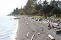 Trail Bay, and the seawall which runs alongside it, at the southern end of the village.
 Porpoise Bay, at the southern end of Sechelt Inlet, located on the north end of the village.
See also
References
- ↑ "British Columbia Regional Districts, Municipalities, Corporate Name, Date of Incorporation and Postal Address" (XLS). British Columbia Ministry of Communities, Sport and Cultural Development. Retrieved November 2, 2014.
- ↑ Hidden Groves
- ↑ "Carte des écoles." Conseil scolaire francophone de la Colombie-Britannique. Retrieved on 22 January 2015.
- Community Profile: Sechelt District Municipality, Sunshine Coast Regional District, British Columbia; Statistics Canada
- A brief history of Sechelt
- The District of Sechelt
- The Hidden Groves
External links
| Wikimedia Commons has media related to Sechelt, British Columbia. |
| Subdivisions |  | |
|---|---|---|
| Communities | ||
| Metro areas and agglomerations | ||
| District municipalities |
| |
| ||