Searcy, Arkansas
| Searcy, Arkansas | |
|---|---|
| City | |
|
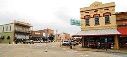
Part of historic downtown Searcy | |
|
Motto: Pride – Progress – Potential "The city where thousands live as millions wish they could." | |
 | |
| Coordinates: 35°14′49″N 91°44′01″W / 35.24694°N 91.73361°WCoordinates: 35°14′49″N 91°44′01″W / 35.24694°N 91.73361°W | |
| Country | United States |
| State | Arkansas |
| County | White |
| Founded | 1838 |
| Incorporated | 1851 |
| Government | |
| • Mayor | David Morris |
| Area | |
| • Total | 14.8 sq mi (38.3 km2) |
| • Land | 14.7 sq mi (38.1 km2) |
| • Water | 0.1 sq mi (0.2 km2) |
| Elevation | 245 ft (80 m) |
| Population (2010) | |
| • Total | 23,768 |
| • Density | 194.5/sq mi (503.6/km2) |
| Time zone | CST (UTC-6) |
| • Summer (DST) | CDT (UTC-5) |
| ZIP codes | 72143, 72145, 72149 |
| Area code(s) | 501 |
| FIPS code | 05-63020 |
| GNIS feature ID | 0078309 |
| Website | Searcy, Arkansas |
Searcy (/ˈsɜːrsi/ SUR-see) is the largest city and county seat[1] of White County, Arkansas, United States. According to 2014 Census Bureau estimates, the population of the city is 23,768.[2] It is the principal city of the Searcy, AR Micropolitan Statistical Area which encompasses all of White County. The city takes its name from Richard Searcy, a judge for the Superior Court of the Arkansas Territory. A college town, Searcy is the home of Harding University.
History
Israel Moore, who had traveled west from Philadelphia, was in charge of laying out Searcy's original streets, and "he proceeded to name the major streets of Searcy for those of downtown Old Philadelphia near Independence Hall; Race, Arch, Market, Vine, Spring, and the tree-honoring streets of Cherry, Spruce, Locust and Pine."[3] In 1957, Searcy named Moore Street after the 19th-century founder.
Spring Street also has a namesake in Old City Philadelphia, but it, along with downtown Searcy's Spring Park, may refer to the early history of the Searcy area, when the community was known as White Sulphur Springs. As early as 1834, local springs with purported therapeutic properties initially drew visitors to the area, similar to the popular attraction to Hot Springs.
During the American Civil War, the Battle of Whitney's Lane was fought near Searcy though the exact site is disputed. Searcy Landing, on the Little Red River, is the final resting place for some Union Army soldiers.
Searcy was incorporated on August 6, 1851,[4]
Searcy was a stop on the defunct Missouri and North Arkansas Railroad, which provided passenger and freight service from 1906 to 1946 from Joplin, Missouri, to Helena in Phillips County in eastern Arkansas.[5]
On August 9, 1965, 53 contract workers were killed in a fire in a LGM-25C Titan II missile silo outside Searcy. It was one of the largest industrial accidents in American history.[6]
Despite having lost many factory jobs in the late 20th century, Searcy has recently experienced an economic revitalization. Much of the new revenue is derived from the leasing of mineral rights to natural gas companies. Some residents express concern about the environmental impact of the extensive drilling projects that have taken place.[7] With the decline of gas and oil exploration, Searcy unemployment now averages 33% higher than the national unemployment average.[8]
Geography
Searcy is located at 35°14′49″N 91°44′1″W / 35.24694°N 91.73361°W (35.247043, -91.733706).[9] According to the United States Census Bureau, the city has a total area of 14.8 square miles (38 km2), of which 14.7 square miles (38 km2) is land and 0.1 square miles (0.26 km2) (0.54%) is water.
Climate
The climate in this area is characterized by hot, humid summers and generally mild to cool winters. According to the Köppen Climate Classification system, Searcy has a humid subtropical climate, abbreviated "Cfa" on climate maps.[10]
Demographics
| Historical population | |||
|---|---|---|---|
| Census | Pop. | %± | |
| 1860 | 621 | — | |
| 1870 | 874 | 40.7% | |
| 1880 | 840 | −3.9% | |
| 1890 | 1,203 | 43.2% | |
| 1900 | 1,995 | 65.8% | |
| 1910 | 2,331 | 16.8% | |
| 1920 | 2,836 | 21.7% | |
| 1930 | 3,387 | 19.4% | |
| 1940 | 3,670 | 8.4% | |
| 1950 | 6,024 | 64.1% | |
| 1960 | 7,272 | 20.7% | |
| 1970 | 9,040 | 24.3% | |
| 1980 | 13,612 | 50.6% | |
| 1990 | 15,180 | 11.5% | |
| 2000 | 18,928 | 24.7% | |
| 2010 | 22,858 | 20.8% | |
| Est. 2015 | 24,196 | [11] | 5.9% |
As of the census[13] of 2014, there were 23,768 people, 8,140 households, and 4,495 families residing in the city. The population density was 1,287.4 people per square mile (497.2/km²). There were 9,244 housing units at an average density of 503.6 per square mile (194.5/km²). The racial makeup of the city was 86.8% White, 7.5% Black or African American, 0.5% Native American, 1.3% Asian, 0.1% Pacific Islander, 1.09% from other races, and 1.9% from two or more races. 4.6% of the population were Hispanic or Latino of any race.
There were 8,140 households out of which 27.4% had children under the age of 18 living with them, 51.8% were married couples living together, 10.8% had a female householder with no husband present, and 34.1% were non-families. 29.5% of all households were made up of individuals and 14.7% had someone living alone who was 65 years of age or older. The average household size was 2.28 and the average family size was 2.86.
In the city the population was spread out with 20.5% under the age of 18, 23.4% from 18 to 24, 23.3% from 25 to 44, 17.8% from 45 to 64, and 14.7% who were 65 years of age or older. The median age was 30 years. For every 100 females there were 97.5 males. For every 100 females age 18 and over, there were 97.5 males.
The median income for a household in the city was $33,415, and the median income for a family was $41,334. Males had a median income of $32,445 versus $21,142 for females. The per capita income for the city was $19,427. About 11.7% of families and 15.0% of the population were below the U.S. poverty threshold, including 18.1% of those under age 18 and 8.0% of those age 65 or over.
Economy
One of the state's largest banks, First Security Bank, was established in Searcy in 1932 as Security Bank. First Security now has over $3.2 billion in assets and 70 locations in Arkansas.
In July 1978 Wal-Mart opened its first distribution center (outside of Bentonville) in Searcy. The facility is still open as a Sam's Club Distribution Center.[14]
In recent years, ITT, Maytag, and Kohler closed large factories in the city. Many companies associated with natural gas that supported the brief natural gas boom have also left the city and the economy has suffered. According to zillow.com, Housing has lost approximately 8% of it value since 2012.
Latina Imports and Latina Nursery are also located in Searcy and is one of the largest female, Hispanic-owned companies in Arkansas.
Sales tax for purchases in Searcy is 9.5% [15]
Education
Searcy is served by two public school districts. Searcy Public Schools — including Searcy High School, three elementary schools and middle and junior high campuses — serve all but the far eastern portion of the city. That portion of the city is within the Riverview School District — a consolidation of districts serving Kensett, Griffithville, Judsonia, and surrounding communities in southeastern White County extending to West Point and Georgetown. Previously, the Riverview portion of Searcy was part of the Kensett school district; Riverview High School was built in eastern Searcy following the consolidation.
|
|
|
Colleges and Universities
- Harding University, a private, Christian university affiliated with the Churches of Christ founded in 1924, has its main campus in Searcy. Harding moved to Searcy in 1934 from Morrilton. The university has developed and expanded to include 49 buildings on more than 350 acres (1.4 km2). With more than 6,100 students, Harding University is the largest private university in Arkansas.
- Arkansas State University-Searcy, formerly operating as Foothills Technical Institute, is a technical campus of nearby Arkansas State University Beebe. It offers several two-year programs. In order to create drilling jobs for local populace, ASU-Searcy has partnered in training with the natural gas industry that is developing local natural resources.[17]
Notable people
- Mike Beebe, former governor
- Ed Bethune, former U. S. representative, 1979-1985.
- Mark Biviano, former state representative, 2011-2015.[18]
- George W. Bond, educator.[19]
- John Paul Capps, politician.
- Rachel Carter, theater director.
- Weston Dacus, NFL linebacker.
- Beth Ditto, singer-songwriter.
- Les Eaves, state representative for White County since 2015[20]
- James Hannah, Chief Justice of the Arkansas Supreme Court
- Sarah Hudson-Pierce, book publisher.
- Odell Pollard, (deceased) politician.
References
- ↑ "Find a County". National Association of Counties. Retrieved 2011-06-07.
- ↑ "Annual Estimates of the Population for All Incorporated Places in Arkansas" (CSV). 2005 Population Estimates. U.S. Census Bureau, Population Division. June 21, 2006. Retrieved November 16, 2006.
- ↑ Dr. Raymond Muncy, Searcy, Arkansas: A frontier town grows up with America
- ↑ "Searcy (White County)". Butler Center for Arkansas Studies at the Central Arkansas Library System. Retrieved 29 January 2014.
- ↑ "H. Glenn Mosenthin, "Missouri and North Arkansas Railroad"". encyclopediaofarkansas.net. Retrieved April 28, 2013.
- ↑ Stumpf, David K. (2000). Titan II: A History of a Cold War Missile Program. University of Arkansas Press. ISBN 1557286019.
- ↑ Hambrick, Pat (September 2, 2007). "Natural State No More". The Daily Citizen (Searcy). Retrieved September 2, 2007.
- ↑ http://www.homefacts.com/unemployment/Arkansas/White-County/Searcy.html
- ↑ "US Gazetteer files: 2010, 2000, and 1990". United States Census Bureau. 2011-02-12. Retrieved 2011-04-23.
- ↑ Climate Summary for Searcy, Arkansas
- ↑ "Annual Estimates of the Resident Population for Incorporated Places: April 1, 2010 to July 1, 2015". Retrieved July 2, 2016.
- ↑ "Census of Population and Housing". Census.gov. Retrieved June 4, 2015.
- ↑ "American FactFinder". United States Census Bureau. Retrieved 2008-01-31.
- ↑ http://www.mwpvl.com/html/walmart.html
- ↑ http://www.sale-tax.com/Arkansas
- ↑ "Learning and Growing in Christ". Liberty Christian School. Retrieved July 10, 2013.
- ↑ Willems, Jack (December 19, 2007). "Drill Training Program Coming to ASU-Searcy". The Daily Citizen (Searcy). Retrieved December 20, 2007.
- ↑ "Mark Biviano, R-46". arkansashouse.org. Retrieved December 29, 2013.
- ↑ "George W. Bond". findagrave.com. Retrieved August 5, 2013.
- ↑ "Les Eaves". arkansashouse.org. Retrieved April 3, 2015.
Further reading
- Muncy, Raymond Lee. Searcy, Arkansas: A Frontier Town Grows up with America. Harding Press: Searcy, 1976.
External links
| Wikimedia Commons has media related to Searcy, Arkansas. |
- Official website
- Searcy Chamber of Commerce official website
- The Daily Citizen, the local newspaper.
- Searcy information page from The Encyclopedia of Arkansas History & Culture
- Encyclopedia of Arkansas History & Culture entry: Searcy (White County)
Municipalities and communities of White County, Arkansas, United States | ||
|---|---|---|
| Cities | 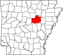 | |
| Towns | ||
| Unincorporated communities |
| |