Seale, Surrey
| Seale | |
 St Laurence church |
|
 Seale |
|
| Population | 907 (2001 Civil Parish Census)[1] |
|---|---|
| OS grid reference | SU8947 |
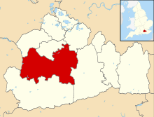
| Civil parish | Seale and Sands |
| District | Guildford |
| Shire county | Surrey |
| Region | South East |
| Country | England |
| Sovereign state | United Kingdom |
| Post town | Farnham |
| Postcode district | GU10 |
| Dialling code | 01252 |
| Police | Surrey |
| Fire | Surrey |
| Ambulance | South East Coast |
| EU Parliament | South East England |
| UK Parliament | Guildford |
Coordinates: 51°13′16″N 0°39′47″W / 51.221°N 0.663°W
Seale is a village in Surrey, England. Seale covers most of the civil parish of Seale and Sands and the steep slope and foot of the south side of the Hog's Back (mid-western section of the North Downs between Farnham and Guildford) as well as a large hill which exceeds it – as such is part of the Surrey Hills Area of Outstanding Natural Beauty.
The Sands, including Sandy Cross forms the rest of the local government rural unit that provides certain minor services. Major services are provided by Guildford Borough Council and Surrey County Council. Across the old nucleus and mostly below the North Downs passes a short stretch of the long-distance footpath, the Pilgrims' Way (North Downs Way). Littleworth Cross is the southern sparsely inhabited junction settlement on minor woodland lanes, which has a heritage-listed park and garden which played host to an important event in the evolution of the work of international early 20th century homes and gardens designer Gertrude Jekyll. The west of the parish contains Farnham Golf Club.
Etymology
- Current localities
Seale derives from the Old English word for "hall" or, alternatively, for "willow" (see for example Salfords).[2]
The Sands is not a relatively old name for any part of Seale, first recorded in Tudor period records, and derives from the quantities of Bargate sandstone and sand present in the far north-west of the Greensand Ridge especially in its high uplands, crowned here by the highest point in the parish, Crooksbury Hill.
- Former settlement or farmstead
Binton Farm takes its name from a Saxon settlement of Binton, which bears the prefix of a Old English personal name and standard suffix for any settlement.[2]
Topography

At the top of a short dry valley, at the foot of the steep Hog's Back, is the parish church of St Laurence, Seale. 800m down the valley is a spring, whose stream leads to Cutt Mill and hence to the Wey. The land undulates, between 165m in the southwest, down to 55m in the east. The north border is the 100 to 140m crest of a long range of hills with the popular name, the Hog's Back.[3]
The parish is almost square, 2 miles east to west and north to south. It covers 887 hectares (2,190 acres)[3][4] most of this is open countryside. The parish of Seale (combined villages of Seale and Sands) has a population of 900,[1]
Apart from houses by the old school, most of the houses in the parish are to the south, along Binton Lane and in The Sands.
History
.jpg)
.jpg)
Seale in the Kingdom of England remained in its county but was also in the hundred of Farnham[n 1]. Successive bishops retained right of free warren and other manorial privileges into the 19th century.
Seale's medieval parish church and rector served equally Tongham to the north until 1866, however much of the land was owned by the Bishop of Winchester who owned much of far-west Surrey since the early holder of that position Henry (of Blois) or Winchester, who used his power and status to build Farnham Castle.
The manor farm, evidencing this, were tenants of the Bishops of Winchester "for three lives" from 1839 (although they sold this interest in 1856).[5]
From the Tudor period, as evidenced by memorials in Seale church, the main landowner was the Woodroffe family (of whom two, David and Nicholas, father and son, were Sheriffs of London in 1554 and 1573 respectively), and later, by descent through a female line, the Chester family. They were seated at 'Poyle', Tongham, on the other side of the Hog's Back, whose landholdings extended into what became the reduced Seale and Sands parish. The mansion at Poyle Park is now demolished and its lands subdivided in the twentieth century – an interior from Poyle Park is on display in the Museum of London.
'Wood' Lane, which runs from the nucleus of Seale up to the top of the Hog's Back, shares its name with that of the family who leased Seale Manor Farm.
Amenities
Village hall
A village hall provides regular events, near the old school and hosts parish council meetings.
Church
The church was established in the 12th century as an outpost of Waverley Abbey. The bell tower houses a peal of six bells, the oldest and largest cast in the 16th century. The church was extensively restored and enlarged in about 1860. It is served by a Rector, who now also has care of the adjacent parishes of Puttenham and Wanborough. These three parishes were formally merged in 2004, although they retain their separate places of worship. Tongham was originally part of the parish of Seale, but it became an independent parish in 1866.[6]
Golf course
In the west of the parish, associated with The Sands which is immediately south-east of it, is Farnham Golf Club. The first five holes start in parkland after which there is a sudden change in scenery as the pine trees close in and the heather replaces the grass.[7]
Landmarks
Heathersett, Littleworth and park gardens
The 1873, rubblestone built, stone dressed, Grade II listed building in its listed park in the far south known as Heathersett, Littleworth has been attributed to R. Norman, architect.[8] The listed park is due to its later designer, Gertrude Jekyll. James Mangle lived at Valewood, Haslemere, one of the earliest rhododendron collectors and hybridisers. When James died in 1884, most of his plant collection was brought to his brother Harry's Littleworth Cross and Harry continued hybridising and exhibiting rhododendrons with the help of his sister Clara. Gertrude Jekyll (1843–1932), who lived at Munstead, knew the Mangles family and was visiting one afternoon in May 1889 when she was introduced to a young architect, Edwin Lutyens (1869–1944) who was designing a gardener's cottage and some garden buildings for Harry Mangles. The meeting was important for both Lutyens and Jekyll: she discovered someone with a similar love of the vernacular architecture of south-west Surrey, who would design her new home, Munstead Wood, and through her, he was introduced to many potential clients. Lutyens and Jekyll began a collaboration of building and garden design that would last until her death in 1932.
Manor Farm
Adjacent to the church are 17th and 18th century joined buildings known as Manor Farm converted into craft shops and a tea room.[9]
Oldest cluster
Manor Farm Cottages,[10] and Seale Lodge Cottages[11] stand opposite the church, clustered around the craft shop/tea room. These date to the early 18th century. Beside them is Stable Cottage of later that century.[12]
James Mangles, who lived at Valewood, Haslemere, was one of the earliest rhododendron collectors and hybridisers. When James died in 1884, most of his plant collection was brought to Littleworth Cross and Harry continued hybridising and exhibiting rhododendrons, with the help of his sister Clara. Gertrude Jekyll (1843–1932), who lived nearby at Munstead, knew the Mangles family and was visiting one afternoon in May 1889 when she was introduced to a young architect, Edwin Lutyens (1869–1944) who was designing a gardener's cottage and some garden buildings for Harry Mangles. The meeting was important for both Lutyens and Jekyll: she discovered someone with a similar love of the vernacular architecture of south-west Surrey, who would design her new home, Munstead Wood (qv), and through her, he was introduced to many potential clients. Lutyens and Jekyll began a collaboration of building and garden design that would last until her death in 1932.
- Hampton Estate
Most of the non-forested, agricultural land in Seale is appurtenant to (attached to or let by the owners of) Hampton Lodge, a Grade II listed Regency period mansion of c.1810. The tall two-storey house is Stuccoed brick to its façade with mansard slate roofs and some fishscale banding.[13] This estate is an early 20th-century merger of land formerly owned by the Long family, land formerly that of Seale Lodge, and agricultural and parkland formerly comprising the Great Down estate, centred on another mansion at the top of the Hog's Back, Great Down, which was demolished in the 1950s. The Hampton Estate was acquired by Eustace Thornton in 1929. He was succeeded by his son, Sir Richard Thornton, KCVO, OBE, Lord Lieutenant of Surrey 1986–1997 and then by Sir Richard's daughter and son-in-law, Bridget and Bill Biddell.
- Former landmarks
Seale Lodge, built in ornate style with surrounding landholdings fell into dilapidation and was demolished c. 1970.
The village school has closed and been converted into a private house.
Localities
The Sands
The Sands, is the largest settlement in the parish, green-buffered from all other settlements. The Sands has a pub, The Barley Mow. Its local shop and post office has closed.
Sandy Cross
On the Seale side of Farnham Golf Course is part of the parish sometimes known as Sandy Cross, towards the west it turns at an informal point into Furze Hill and a heavily pined area. Here behind a few houses is a worked sand pit.[14]
Demography and housing
The United Kingdom Census 2011 reveals that parish, had 907 people living in 360 households.[1] Almost all of these had farmland or gardens.[14]
| Output area | Population | Households | Owned outright | Owned with a loan | hectares[1] |
|---|---|---|---|---|---|
| Seale and Sands | 907 | 360 | 169 (46.9%) | 127 (35.3%) | 887[1] |
The proportion of households in the civil parish who owned their home outright compares to the regional average of 35.1%. The proportion who owned their home with a loan compares to the regional average of 32.5%. The remaining % is made up of rented dwellings (plus a negligible % of households living rent-free).
| Output area | Detached | Semi-detached | Terraced | Flats and apartments | Caravans/temporary/mobile homes | shared between households[1] |
|---|---|---|---|---|---|---|
| (Civil Parish) | 244 | 98 | 12 | 4 | 2 | 0 |
The average level of accommodation in the region composed of detached houses was 28%, the average that was apartments was 22.6%.
Transport
The village is well connected by roads but not rail and had approximately 50% of its working population recorded in 2011 as commuting 20–40 km, living in the rural outer Metropolitan Green Belt yet commuting to major employment areas such as London, Farnborough, Fleet and Aldershot.[1]
Specific long-distance roads are the A31 and the A331 roads (the Blackwater Valley Route) dual carriageway; along the entire northern border and 1 mile (1.6 km) north-west, respectively.
See also
Further reading
- Anonymous The Church of St. Laurence Seale: A Short Guide and History [Published by the church]
External links
| Wikimedia Commons has media related to Seale, Surrey. |
- village website Run by Seale and Sands Parish Council
- Hampton Estate website
- Francis Frith historic photographs of Seale
- Photograph of Seale church and churchyard
- Stained Glass Windows at Stained Glass Records: St. Lawrence Seale, Surrey
Notes and references
- Notes
- ↑ Hundreds faded into economic, then official insignificance by the late 19th century and completely by the time of the Local Government Act 1894
- References
- 1 2 3 4 5 6 7 Key Statistics; Quick Statistics: Population Density United Kingdom Census 2011 Office for National Statistics Retrieved 6 November 2013
- 1 2 English Place Name Studies, Surrey volume
- 1 2 Grid square map Ordnance survey website
- ↑ http://www.atrk01.dsl.pipex.com/VillagesX.htm Archived 22 November 2004 at the Wayback Machine.
- ↑ Surrey County Council history pages
- ↑ St Lawrence's, Seale The Church of England Retrieved 10 November 2013
- ↑ Farnham Golf Club English Golf Courses (directory with reviews) Retrieved 10 November 2013
- ↑ Historic England. "Details from listed building database (1294453)". National Heritage List for England.
- ↑ Manor ('House') 'Farm' (Craft shops and tea room) Historic England. "Details from listed building database (1029604)". National Heritage List for England.
- ↑ Manor Farm CottagesHistoric England. "Details from listed building database (1294481)". National Heritage List for England.
- ↑ Seale Lodge Cottages Historic England. "Details from listed building database (1029605)". National Heritage List for England.
- ↑ Stable Cottage Historic England. "Details from listed building database (1294487)". National Heritage List for England.
- ↑ Hampton Lodge Historic England. "Details from listed building database (1029608)". National Heritage List for England.
- 1 2 OS Map with Listed Buildings and Parks marked
 |
Aldershot | Tongham Ash Green |
Wanborough | |
| Runfold | |
Puttenham | ||
| ||||
| | ||||
| Puttenham & Crooksbury Commons Tilford |
Elstead | Shackleford |