Sea to sea trail
| Sea to sea trail | |
|---|---|
|
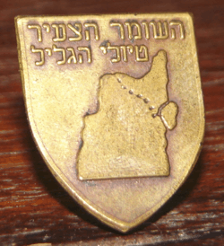
A pin given to participants of a "sea-to-sea" hike, Hashomer Hatzair youth movement, early 1980s. | |
| Length | 89 kilometres (55.3 mi) |
| Location | Northern District, Israel |
| Trailheads | West: Achziv, East: Sea of Galilee |
| Use | Hiking |
| Elevation | |
| Highest point | 1,200 m (3,900 ft) |
| Lowest point | −400 m (−1,300 ft) |
| Hiking details | |
| Season | Fall and spring |
The Sea to Sea Trail (Hebrew: שביל מים לים, Shvil MiYam LeYam) is a hiking path that crosses the north of Israel. Its western end is in the Mediterranean Sea at Achziv, near the Lebanese border in the far north of the country, and it extends to the Sea of Gallilee, a length of approximately 89 km (55.3 mi). The trail is marked with different colors in different sections, and takes an average of 3–4 days to complete.[1]
The trail was very popular among youth organizations in the 1950s and 60s.
The Hebrew Scouts Movement in Israel is organizing the Sea to Sea hike every year during the Passover holidays, for 14 years old Scouts since 1919.[2]
The first part of the trail climbs from the Sea of Gallilee through Nahal Amud to the grave of Rabbi Shimon bar Yochai[3] grave on Mount Meron. This section of the trail is part of the Israel National Trail. The second section of the trail goes from Mount Meron through Nahal Kziv to Ma'alot-Tarshiha. The third day of the hike follows Nahal Kziv to the sea.[1]
See also
References
- 1 2 http://www.israelnationaltrail.com/INTForum/tabid/469/forumid/11/threadid/425/scope/posts/Default.aspx
- ↑ http://www.zofim.org.il/pics/file_board/sea%20to%20sea%20trip.pdf About the Sea to Sea Hike
- ↑ http://www.goisrael.com/Tourism_Eng/Tourist%20Information/Jewish%20Themes/Jewish_Sites/Pages/The%20Tomb%20of%20Rabbi%20Shimon%20Bar%20Yochai%20jew.aspx