Sea Lion Tarn
| Sea Lion Tarn | |
|---|---|
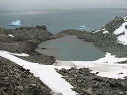 Sea Lion Tarn from the north slopes of Atlantic Club Ridge, with South Bay in the background | |
| Location | Livingston Island |
| Coordinates | 62°38′48″S 60°22′14″W / 62.64667°S 60.37056°WCoordinates: 62°38′48″S 60°22′14″W / 62.64667°S 60.37056°W |
| Basin countries | (Antarctica) |
| Surface area | 0.3 ha (0.74 acres) |
Location of Hurd Peninsula on Livingston Island in the South Shetland Islands.

Topographic map of central-eastern Livingston Island featuring Sea Lion Tarn.

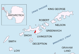
Topographic map of Livingston Island, Greenwich, Robert, Snow and Smith Islands.
Sea Lion Tarn (Ezero Morski Lav \'e-ze-ro 'mor-ski 'l&v\) is a freshwater tarn with an area of 0.3 ha (0.74 acres) located between Sea Lion Glacier and the north-western slopes of Atlantic Club Ridge on Hurd Peninsula in eastern Livingston Island in the South Shetland Islands, Antarctica. The lake drains westward through a 100 m creek into South Bay.
The feature takes its name from the adjacent Sea Lion Glacier.
Location
The midpoint is located at 62°38′48″S 60°22′14″W / 62.64667°S 60.37056°W (Bulgarian mapping from a 1995-1996 ground survey).
Maps
- L.L. Ivanov. Livingston Island: Central-Eastern Region. Scale 1:25000 topographic map. Sofia: Antarctic Place-names Commission of Bulgaria, 1996.
- L.L. Ivanov et al. Antarctica: Livingston Island and Greenwich Island, South Shetland Islands. Scale 1:100000 topographic map. Sofia: Antarctic Place-names Commission of Bulgaria, 2005.
- L.L. Ivanov. Antarctica: Livingston Island and Greenwich, Robert, Snow and Smith Islands. Scale 1:120000 topographic map. Troyan: Manfred Wörner Foundation, 2009. ISBN 978-954-92032-6-4
External links
This article includes information from the Antarctic Place-names Commission of Bulgaria which is used with permission.
This article is issued from Wikipedia - version of the 11/21/2015. The text is available under the Creative Commons Attribution/Share Alike but additional terms may apply for the media files.