Sculptured Rocks Natural Area
| Sculptured Rocks Natural Area | |
| New Hampshire Natural Area | |
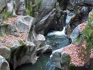 Sculptured Rocks on the Cockermouth River | |
| Country | |
|---|---|
| State | |
| County | Grafton |
| Location | Groton, New Hampshire |
| - coordinates | 43°42′26″N 71°51′16″W / 43.70722°N 71.85444°WCoordinates: 43°42′26″N 71°51′16″W / 43.70722°N 71.85444°W |
| Highest point | |
| - elevation | 1,340 ft (408 m) |
| Lowest point | |
| - elevation | 650 ft (198 m) |
| Website: Sculptured Rocks Natural Area | |
The Sculptured Rocks Natural area is a natural area in Groton, New Hampshire. Its main feature is its namesake, the Sculptured Rocks, which are a series of narrow, sharply carved rock formations that are a popular local swimming hole. They are located on the Cockermouth River, which is the longest tributary of Newfound Lake. The Sculptured Rocks Road, which runs along this same river, shares its namesake with the park.
External links
- Sculptured Rocks Natural Area NH Division of Parks and Recreation
This article is issued from Wikipedia - version of the 10/2/2016. The text is available under the Creative Commons Attribution/Share Alike but additional terms may apply for the media files.