Scott Covered Bridge (Townshend, Vermont)
|
Scott Covered Bridge | |
|
1970 photo | |
  | |
| Nearest city | Townshend, Vermont |
|---|---|
| Coordinates | 43°2′53″N 72°41′50″W / 43.04806°N 72.69722°WCoordinates: 43°2′53″N 72°41′50″W / 43.04806°N 72.69722°W |
| Area | 1 acre (0.40 ha) |
| Built | 1870 |
| Architectural style | Town lattice truss |
| NRHP Reference # | 73000206[1] |
| Added to NRHP | August 28, 1973 |
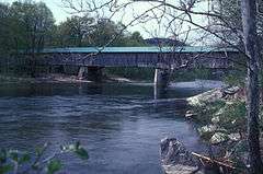
Scott Covered Bridge is a covered bridge spanning the West River in Townshend, Vermont. Built in 1870, it is at 277 feet (84 m) one of the longest covered bridges in the state (the West Dummerston Covered Bridge is longer), exhibiting three different forms of support: a Town lattice truss, kingpost trusses, and laminated arches. The bridge was listed on the National Register of Historic Places in 1973.[1] It is closed to all traffic.
Description and history
The Scott Covered Bridge is located west of Townshend's main village, spanning the West River just west of Vermont Route 30 south of Townshend Dam. The bridge consists of three spans: a main Town lattice truss span that is 166 feet (51 m) long, and two kingspost truss spans with a combined length of 111 feet (34 m). The Town lattice truss has been strengthened with laminated arches. The bridge has a total width of 20 feet (6.1 m), and a roadway width of 16 feet (4.9 m). The sides and gable ends of the bridge are sheathed with vertical board siding.[2]
The bridge was constructed in 1870, with original ownership by the town of Townshend.[3] Originally, the kingspost trusses were exposed, but they were covered in 1873.[2] The bridge was ceded to the Vermont Historical Commission in 1955 and subsequently added to the National Register of Historic Places in 1973.[3] The bridge has been modified on three occasions to improve the structural stability: adding a concrete facing to the piers in 1915; adding structural support beams in 1961, and a concrete pier in 1981.[3] Since 2012, the bridge have been closed to foot traffic, after a routine inspection showed serious structural integrity issues.[4]
See also
- National Register of Historic Places listings in Windham County, Vermont
- List of bridges on the National Register of Historic Places in Vermont
- List of Vermont covered bridges
References
- 1 2 National Park Service (2010-07-09). "National Register Information System". National Register of Historic Places. National Park Service.
- 1 2 "NRHP nomination for Scott Covered Bridge" (PDF). National Park Service. Retrieved 2015-12-29.
- 1 2 3 Faher, Mike (2013-04-04). "Townshend's Scott Bridge stable, but future is shaky". Brattleboro Reformer. Retrieved December 19, 2015.
- ↑ "National Society for the Preservation of Covered Bridges". www.coveredbridgesociety.org. October 30, 2015. Retrieved 2015-12-19.