Scollard Formation
| Scollard Formation Stratigraphic range: Maastrichtian to Danian | |
|---|---|
 Scollard Formation exposed along the Red Deer River, Alberta. The Tyrannosaurus rex skeleton on display at the Royal Tyrrell Museum of Palaeontology was excavated in the center of image. | |
| Type | Geological formation |
| Unit of | Edmonton Group |
| Sub-units | Ardley coal zone |
| Underlies | Paskapoo Formation |
| Overlies | Battle Formation |
| Thickness | Up to 300 metres (980 ft)[1] |
| Lithology | |
| Primary | Sandstone, siltstone, shale |
| Other | Coal, bentonite |
| Location | |
| Coordinates | 51°56′19″N 112°55′37″W / 51.93861°N 112.92694°WCoordinates: 51°56′19″N 112°55′37″W / 51.93861°N 112.92694°W |
| Region |
|
| Country |
|
| Type section | |
| Named for | Scollard Canyon at Dry Island Buffalo Jump Provincial Park |
| Named by | Irish, E.J.W[2] |
The Scollard Formation is an Upper Cretaceous to lower Palaeocene stratigraphic unit of the Western Canada Sedimentary Basin in southwestern Alberta.[1][3] Its deposition spanned the time interval from latest Cretaceous to early Paleocene, and it includes sediments that were deposited before, during, and after the Cretaceous-Paleogene (K-Pg) extinction event. It is significant for its fossil record, and it includes the economically important coal deposits of the Ardley coal zone.
Lithology
The Scollard Formation consists primarily of sandstones and siltstones, interbedded with mudstones and, in the upper portion, coal seams, as well as minor amounts of bentonite.[1] The sediments were eroded from the Canadian Cordillera, and were transported eastward by river systems and deposited in fluvial channel and floodplain environments.
Stratigraphy
The Scollard is usually classified as the uppermost formation of the Edmonton Group, although some early workers included it in the overlying Paskapoo Formation.[4] It is subdivided into an upper, coal-bearing member that consists of the Ardley coal zone, and a lower member that lacks significant coal.[1] Neither member has been formally named.
Age
The K-Pg boundary occurs at the base of the lowermost seam of Ardley coal zone, based on dinosaurian and microfloral evidence,[5] as well as the presence of the terminal Cretaceous iridium anomaly.[6] The upper member is therefore of early Paleocene age, while the lower member is of latest Cretaceous age.
Distribution
The Scollard Formation is present in the subsurface throughout much of southwestern Alberta,[7] and it outcrops extensively along the banks of the Red Deer River in the area of Trochu.[8] Both the upper and lower members thin from west to east. Thicknesses for each member range from more than 300 metres (980 ft) near the foothills of the Canadian Rockies to less than 100 metres (330 ft) near the outcrops in south-central Alberta.[1]
Relationship to other units
The Scollard Formation rests disconformably on the Late Cretaceous Battle Formation in the southwestern Alberta plains, on the Wapiti Formation in the northwestern plains, and on the Brazeau Formation in the foothills. It is unconformably overlain by the Paskapoo Formation, and where the Paskapoo has been removed by erosion, the Scollard is exposed at surface or covered by Quaternary sediments.
The Scollard grades into the Willow Creek Formation in the southern Alberta plains and the Coalspur Formation in the Alberta foothills. The Ardley coal zone in the upper portion is equivalent to the lower part of the Coalspur coal zone of the Coalspur Formation,[9] and is correlated with the lower part of the Ravenscrag Formation of southern Saskatchewan, which is also coal bearing.[10] The Late Cretaceous member is equivalent in age to the Frenchman Formation of Saskatchewan, the Hell Creek Formation of Montana, and the Lance Formation of Wyoming .[1]
Coal deposits
The coal seams of the Ardley coal zone attain thicknesses in excess of 7 metres (20 ft) in some areas. The zone is present at shallow depths and, in places, exposed at surface, along a trend between Red Deer and Edmonton. The coal is typically of sub-bituminous B to C rank, although more deeply buried Scollard coals farther to the west reach high-volatile bituminous rank. The Ardley coal has been mined in the Red Deer area, and is currently being mined west of Edmonton to fuel mine-mouth electric power generating stations.[11]
Paleontology
The Scollard Formation preserves the remains of vertebrates, especially dinosaurs and, rarely, mammals, as well as a wide range of plant fossils. The Scollard strata span the K-Pg boundary, therefore the lower member of the Scollard provides a record of the last of the dinosaurs, while the upper member records the dawn of the Age of Mammals after the K-Pg extinction event.
Plant fossils
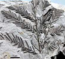
Plant fossils from the upper, early Paleocene member of the Scollard Formation include species of the ferns Botrychium, Woodwardia and Azolla; the conifers Metasequoia and Glyptostrobus; the monocot Limnobiophyllum (a relative of duckweeds); and the dicots Cercidiphyllum and Platanus.[12][13]
Theropods
| Theropods reported from the Scollard Formation | ||||||
|---|---|---|---|---|---|---|
| Genus | Species | Location | Stratigraphic position | Material | Description | Images |
|
Indeterminate[14] |
Teeth |
| ||||
|
cf. Paronychodon[15] |
Indeterminate[14] |
|||||
|
cf. R. gilmorei[17] |
||||||
|
cf. R. isosceles[18] |
||||||
|
cf. S. langstoni[14] |
||||||
|
Indeterminate[14] |
||||||
|
T. rex[14] |
||||||

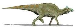
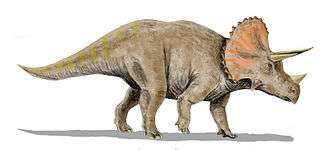
Ornithischians
Color key
|
Notes Uncertain or tentative taxa are in small text; |
| Ornithischians reported from the Scollard Formation | ||||||
|---|---|---|---|---|---|---|
| Genus | Species | Location | Stratigraphic position | Material | Description | Images |
|
A magniventris[14] |
| |||||
|
E. annectens[14] |
||||||
|
L. gracilis[14] |
||||||
|
"Indeterminate[14] |
||||||
|
T. edmontonensis[14] |
Referred to Thescelosaurus sp.[20] | |||||
|
T. horridus[14] |
||||||
See also
Footnotes
- 1 2 3 4 5 6 Mossop, G.D. and Shetsen, I., (compilers), Canadian Society of Petroleum Geologists (1994). "The Geological Atlas of the Western Canada Sedimentary Basin, Chapter 24: Upper Cretaceous and Tertiary strata of the Western Canada Sedimentary Basin". Retrieved 2013-08-01.
- ↑ Irish, E.J.W., 1970. The Edmonton Group of south-central Alberta; Canadian Society of Petroleum Geologists (CSPG), Bulletin of Canadian Petroleum Geology, vol. 18, no. 2 (June), pp. 125-155.
- ↑ Lexicon of Canadian Geological Units. "Scollard Formation". Retrieved 2009-02-06.
- ↑ Hamblin, A.P. (2004). "Paskapoo-Porcupine Hills Formation in western Alberta: Synthesis of regional geology and resource potential. Geological Survey of Canada, Open File 4679.". Retrieved 2013-08-01.
- ↑ Lerbekmo, J.F., Singh, C., Jarzen, D.M., and Russel, D.A. 1979. The Cretaceous-Tertiary boundary in south-central Alberta - a revision based on dinosaurian and microfloral evidence. Canadian Journal of Earth Science, 16: 325-330.
- ↑ Lerbekmo, J.F. and St. Louis, R.M. 1985. The terminal Cretaceous iridium anomaly in the Red Deer Valley, Alberta. Canadian Journal of Earth Science, 23: 120-124.
- ↑ Prior, G. J., Hathaway, B., Glombick, P.M., Pana, D.I., Banks, C.J., Hay, D.C., Schneider, C.L., Grobe, M., Elgr, R., and Weiss, J.A. (2013). "Bedrock Geology of Alberta. Alberta Geological Survey, Map 600". Retrieved 2013-08-13.
- ↑ "Introduction," Ryan and Russel (2001); page 279.
- ↑ Langenberg, C.W., Berhane, H., Sweet, A.R., Marchioni, D. and Heamann, L.M. 2007. Regional correlations of the Ardley coal zone, Alberta. Alberta Geological Survey, Earth Sciences Report 2007-5, 21 p.
- ↑ Alberta Geological Survey, 2013. "Alberta Table of Formations; Alberta Energy Regulator" (PDF). Retrieved 2016-06-20.
- ↑ Mossop, G.D. and Shetsen, I., (compilers), Canadian Society of Petroleum Geologists (1994). "The Geological Atlas of the Western Canada Sedimentary Basin, Chapter 33: Coal Resources of the Western Canada Sedimentary Basin". Retrieved 2013-08-01.
- ↑ Chandrasekharam, A., 1974. Megafossil flora from the Genesee locality, Alberta, Canada. Palaeontographica, Abt. A, Band 147, 41 p.
- ↑ Christophel, D.C., 1976. Fossil floras from the Smoky Tower locality, Alberta, Canada. Palaeontographica, Abt. B, Band 157, 43 p.
- 1 2 3 4 5 6 7 8 9 10 11 12 13 14 15 16 17 18 19 20 "Dinosaur distribution (Late Cretaceous; North America; Yukon Territory, Canada)." In: Weishampel et al. Page 578.
- ↑ Listed as "cf. Paronychodon sp." in Weishampel et al. Page 578.
- ↑ Referred to by the obsolete spelling "Ricardoestesia" in Weishampel et al. Page 578.
- ↑ Listed as "cf. Ricardoestesia gilmorei" in Weishampel et al. Page 578.
- ↑ Listed as "cf. Ricardoestesia isosceles" in Weishampel et al. Page 578.
- ↑ Listed as "cf. Troodon sp." in Weishampel et al. Page 578.
- ↑ Boyd, Clint A.; Brown, Caleb M.; Scheetz, Rodney D.; and Clarke, Julia A. (2009). "Taxonomic revision of the basal neornithischian taxa Thescelosaurus and Bugenasaura". Journal of Vertebrate Paleontology 29 (3): 758–770. doi:10.1671/039.029.0328.
References
- Ryan, M. J., and Russell, A. P., 2001. Dinosaurs of Alberta (exclusive of Aves): In: Mesozoic Vertebrate Life, edited by Tanke, D. H., and Carpenter, K., Indiana University Press, pp. 279–297.
- Weishampel, David B.; Dodson, Peter; and Osmólska, Halszka (eds.): The Dinosauria, 2nd, Berkeley: University of California Press. 861 pp. ISBN 0-520-24209-2.