Scituate, Massachusetts
| Scituate, Massachusetts | ||
|---|---|---|
| Town | ||
|
Scituate Harbor | ||
| ||
 Location in Plymouth County in Massachusetts | ||
| Coordinates: 42°11′45″N 70°43′35″W / 42.19583°N 70.72639°WCoordinates: 42°11′45″N 70°43′35″W / 42.19583°N 70.72639°W | ||
| Country | United States | |
| State | Massachusetts | |
| County | Plymouth | |
| Settled | 1630 | |
| Incorporated | 1636 | |
| Government | ||
| • Type | Open town meeting | |
| Area | ||
| • Total | 31.8 sq mi (82.4 km2) | |
| • Land | 17.6 sq mi (45.7 km2) | |
| • Water | 14.2 sq mi (36.8 km2) | |
| Elevation | 30 ft (9 m) | |
| Population (2010) | ||
| • Total | 18,133 | |
| • Density | 1,046/sq mi (404/km2) | |
| Time zone | Eastern (UTC-5) | |
| • Summer (DST) | Eastern (UTC-4) | |
| ZIP code | 02066 | |
| Area code(s) | 339 / 781 | |
| FIPS code | 25-60330 | |
| GNIS feature ID | 0618352 | |
| Website |
www | |


Scituate (![]() i/ˈsɪtʃuːᵻt/)[1] is a seacoast town in Plymouth County, Massachusetts, United States, on the South Shore, midway between Boston and Plymouth. The population was 18,133 at the 2010 census.[2]
i/ˈsɪtʃuːᵻt/)[1] is a seacoast town in Plymouth County, Massachusetts, United States, on the South Shore, midway between Boston and Plymouth. The population was 18,133 at the 2010 census.[2]
For geographic and demographic information on the village of North Scituate, which is a part of Scituate, please see the article North Scituate, Massachusetts.
History
Scituate was settled by a group of people from Plymouth about 1627, who were joined by immigrants from the county of Kent in England. They were initially governed by the General Court of Plymouth, but on October 5, 1636, the town incorporated as a separate entity. The name Scituate is derived from "satuit", the Wampanoag term for cold brook, which refers to a brook that runs to the inner harbor of the town. In 1710, several residents emigrated to Rhode Island and founded Scituate, Rhode Island, naming it after their previous hometown.
The William-Barker House, which still remains near the harbor, was built in 1634.[3] Twelve homes and a sawmill were destroyed in King Philip's War in 1676.[4]
In 1717, the western portion of the original land grant was separated and incorporated as the town of Hanover, and in 1788, a section of the town was ceded to Marshfield. In 1849, another western section became the town of South Scituate, which later changed its name to Norwell. Since then, the borders have remained essentially unchanged.
Fishing was a significant part of the local economy in the past, as was the sea mossing industry. The sea was historically an integral part of the town with occasional incidents such as that described February 13, 1894 in which eight men clinging to the vessel's rigging on a schooner grounded off Third Cliff apparently died before a large crowd watching from shore "literally frozen to the ropes" while unsuccessful rescue efforts continued through the day and their apparently lifeless bodies were covered by nightfall.[5] A small fishing fleet is still based in Scituate Harbor, although today the town is mostly residential.
In 1810, a lighthouse was erected on the northern edge of Scituate Harbor. This lighthouse is now known as Old Scituate Light. During the War of 1812, a British naval raiding party was deterred by the two daughters of the lighthouse keeper playing a fife and drum loudly. The girls and this incident became known as the "American Army of Two" or "Lighthouse Army of Two".
Another notable lighthouse, Minot's Ledge Light, stands approximately one mile off Scituate Neck.
Samuel Woodworth's Old Oaken Bucket house is located in Scituate. The town is also home to the Lawson Tower, a water tower surrounded by a wooden façade, with an observation deck with views of most of the South Shore from the top.
During World War II the Fourth Cliff Military Reservation defended the Scituate area with a battery of two 6-inch guns. It is now a recreation area for Hanscom Air Force Base.[6]
Scituate used to be the site of international broadcasting radio station WNYW, which broadcast on the shortwave bands in the late 1960s.
Geography
According to the United States Census Bureau, the town has a total area of 31.8 square miles (82.4 km2), of which 17.6 square miles (45.7 km2) is land and 14.2 square miles (36.8 km2), or 44.60%, is water.[7] Scituate is bordered on the east by Massachusetts Bay, on the south by Marshfield, on the west by Norwell and Hingham, all of which are in Plymouth County, and on the northwest by Cohasset, in Norfolk County. The town is 19 miles (31 km) northeast of Brockton and 25 miles (40 km) southeast of Boston.
Scituate is considered a South Shore community, located just south of the mouth of greater Boston Harbor. The town is not contiguous; Humarock is a part of Scituate which can only be reached from Marshfield. The latter was formerly connected to the town, but that connection was lost when the mouth of the South River shifted northward as the result of the Portland Gale of 1898. The town's shore varies, with the south (along the mouth of the North River) being surrounded by salt marshes, the middle (around Scituate Harbor) being sandy, and the coast of Scituate Neck (Minot) in the north exhibiting exposed granite bedrock. It is off these rocks that Minot's Ledge lies, home to the town's most famous lighthouse. The inland of the town is mostly wooded, with several brooks and rivers (including Satuit or "Cold Brook", for which the town is named) running through.
The town has no freeways running through it; Massachusetts Route 3 runs through neighboring Norwell. Route 3A runs through the town, and is known as Chief Justice Cushing Highway for this stretch, named for Chief Justice William Cushing (1732–1810). The only other state highway in town is Route 123, which terminates at Route 3A, just 0.7 miles (1.1 km) from the town line.
There is no air service in town; the closest regional airport is Marshfield Municipal Airport, and the closest national and international air service is at Logan International Airport in Boston. There are two MBTA commuter rail stations. One is just off Route 3A in North Scituate, and the other is just east of the intersection of Routes 3A and 123 in the Greenbush neighborhood, which is the line's eastern terminus. The line is connected to an existing line in Braintree, providing service to South Station in Boston.[8]
Named places in the town include:[9]
- Egypt
- First Cliff
- Greenbush (Green Bush)
- Hatherly
- Humarock
- Lawson Tower, a historic water tower which is visible from several miles out at sea
- Minot, including Minot Beach
- North Scituate (formerly Gannett Corner)
- Peggotty Beach
- Rivermoor
- Second Cliff
- Shore Acres
- Sodham
- The Glades
- Sand Hills
- The Connolly House
- Third Cliff
- Kent Village
- The West End
- The Spit
- Driftway
"The Harbor" refers to the business district as well as the harbor itself. Scituate Harbor is used mostly by pleasure boaters and fisherman.[10]
Demographics
| Historical population | ||
|---|---|---|
| Year | Pop. | ±% |
| 1850 | 2,149 | — |
| 1860 | 2,227 | +3.6% |
| 1870 | 2,350 | +5.5% |
| 1880 | 2,406 | +2.4% |
| 1890 | 2,318 | −3.7% |
| 1900 | 2,470 | +6.6% |
| 1910 | 2,482 | +0.5% |
| 1920 | 2,534 | +2.1% |
| 1930 | 3,118 | +23.0% |
| 1940 | 4,130 | +32.5% |
| 1950 | 5,993 | +45.1% |
| 1960 | 11,214 | +87.1% |
| 1970 | 16,973 | +51.4% |
| 1980 | 17,317 | +2.0% |
| 1990 | 16,786 | −3.1% |
| 2000 | 17,863 | +6.4% |
| 2010 | 18,133 | +1.5% |
| * = population estimate. Source: United States Census records and Population Estimates Program data.[11][12][13][14][15][16][17][18][19][20] | ||
As of the census[21] of 2010, there were 18,133 people, 6,694 households, and 4,920 families residing in the town. The population density was 1,039.6 people per square mile (401.5/km2). There were 7,685 housing units at an average density of 447.3 per square mile (172.7/km2). The racial makeup of the town was 96.1% White, 0.8% Black or African American, 0.1% Native American, 0.8% Asian, 0.01% Pacific Islander, 1.4% from other races, and 0.9% from two or more races. Hispanic or Latino of any race were 0.83% of the population.
There were 6,694 households out of which 34.4% had children under the age of 18 living with them, 62.5% were married couples living together, 8.2% had a female householder with no husband present, and 26.5% were non-families. 22.2% of all households were made up of individuals and 10.4% had someone living alone who was 65 years of age or older. The average household size was 2.64 and the average family size was 3.13.
In the town the population was spread out with 26.1% under the age of 18, 4.2% from 18 to 24, 27.7% from 25 to 44, 26.8% from 45 to 64, and 15.3% who were 65 years of age or older. The median age was 41 years. For every 100 females there were 91.3 males. For every 100 females age 18 and over, there were 87.9 males.
The median income for a household in the town was $70,868, and the median income for a family was $86,058 (these figures had risen to $86,723 and $108,138 respectively as of a 2010 estimate)16. Males had a median income of $60,322 versus $40,200 for females. The per capita income for the town was $33,940. About 1.4% of families and 2.6% of the population were below the poverty line, including 1.5% of those under age 18 and 4.8% of those age 65 or over.
The British Daily Mail newspaper has declared Scituate "the most Irish town in America" based on 2010 U. S. Census data, in which 47.5% of residents listed their primary ancestry as Irish.[22]
Transportation
There are no divided highways that run through Scituate, but there are two state roads, Route 3A and Route 123. The nearest airport to Scituate is Marshfield Municipal Airport. The nearest national and international air service can be reached at Logan International Airport and Boston. T. F. Green Airport, located outside Providence, Rhode Island, is an alternative to Logan, although it is located farther away.
The Greenbush Line of the MBTA Commuter Rail begins in Scituate with the Greenbush station, proceeds north to Scituate's second stop, in North Scituate, where it continues to Cohasset and Hingham and finally South Station in Boston. The ride into Boston lasts approximately forty- five minutes.
In late 2015 the GATRA bus program was implemented into Scituate. It rides a set route around the town for the majority of the day at a low cost to the rider.
Government
On the national level, Scituate is a part of Massachusetts's 8th congressional district, and is currently represented by Stephen Lynch. The state's senior (Class II) member of the United States Senate, elected in 2012, is Elizabeth Warren. The junior (Class I) senator is Ed Markey, who was elected a special election in 2013 to fill the seat left vacant by John Kerry, who resigned to become Secretary of State.[23]
On the state level, all of Scituate's voting precincts are represented in the Massachusetts House of Representatives as a part of the Fourth Plymouth district, which also includes the town of Marshfield. The state representative for these precincts is Jim Cantwell. The third precinct is a part of the Third Plymouth district, which includes Hingham, Hull and Cohasset, and is represented by Garrett Bradley. The town is represented in the Massachusetts Senate as a part of the Plymouth and Norfolk district, which includes the towns of Cohasset, Duxbury, Hingham, Hull, Marshfield Norwell and Weymouth. The current state senator is Robert Hedlund[24]
Scituate is governed on the local level by the open town meeting form of government, and is led by a town administrator and a board of selectmen. The town hall, police and fire station 3 are all located in buildings along Route 3A, just down the street from the traditional center of town. There is also a firehouse in Humarock and the Fire Headquarters is on First Parish Rd near Scituate Harbor. Emergency services are also provided by the town, with the nearest hospitals being located in Quincy, Weymouth, Plymouth, and Brockton. There are four post offices throughout the town, located in Humarock, near the harbor, in North Scituate and in Greenbush. The Scituate Town Library is located near Scituate Center, and is a member of the Old Colony Library Network (OCLN). The town also operates a highway department, as well as several parks, beaches and marinas. The Coast Guard also has a station at Scituate Harbor.
In 2002, Scituate voters adopted the Community Preservation Act (CPA) for the acquisition, preservation, restoration or creation of open space, historical purposes, land for recreational use and the creation and support of community housing. Since then, voters have approved funding for many noteworthy projects: restoration of historic treasures like Lawson Tower, Cudworth House, and Stockbridge Mill; purchase of increasingly threatened open space – roughly 120 acres (0.49 km2) to date containing much wildlife and scenic trails; construction of recreational facilities at Hatherly and Cushing Schools, along with Community Basketball courts at Scituate High School.
| Voter Registration and Party Enrollment as of October 15, 2008[25] | |||||
|---|---|---|---|---|---|
| Party | Number of Voters | Percentage | |||
| Democratic | 3,689 | 27.65% | |||
| Republican | 2,282 | 17.11% | |||
| Unaffiliated | 7,314 | 54.83% | |||
| Minor Parties | 55 | 0.41% | |||
| Total | 13,340 | 100% | |||
Education
Scituate's public schools provide co-ed classes for grades K–12. Hatherly Elementary School, Cushing Elementary School, Wampatuck Elementary School and (the most recently opened) Jenkins Elementary School serve grades K–6, Lester J. Gates Intermediate School, known just as "Gates" to most residents, serves grades seven and eight, and Scituate High School serves 9–12. Scituate High's teams are known as the Sailors, and their colors are blue, white, and black. The teams compete in the MIAA's Divisions 2 and 3, in the Patriot League. Their chief rivals are Norwell and Cohasset, whom they border, and Hingham, whom they play in their annual Thanksgiving Day football game.
High school students may also choose to attend South Shore Vocational Technical High School in Hanover free of charge. Also, many students, specifically in high school, commute to private schools in and around Boston, most commonly, Thayer Academy and Archbishop Williams in Braintree, Boston College High School (boys only) in Dorchester, and Notre Dame Academy (girls only) in Hingham. B.C. High enrolled 61 young men from Scituate in the 2005–2006 school year.
Notable people
- Rebecca and Abigail Bates, known as the "American Army of Two," fended off the British army near the Scituate lighthouse with a fife and drum during the War of 1812 (Fortier, Edmund A, An Army of Two Saves the Day)
- George W. Casey, Jr., Chief of Staff of the United States Army (2007–2011)
- Paul Curtis, shipbuilder known for his clipper ships
- William Cushing, one of the original six justices on the United States Supreme Court
- Ted Donato, former Harvard hockey captain with a 13-year NHL career, who won an NCAA championship; played in the Olympics
- Henry Dunster, first president of Harvard University, Puritan/Baptist minister
- Nick Flynn, writer and poet, whose autobiographical Another Bullshit Night in Suck City was adapted into the 2012 film Being Flynn.
- Jacques Futrelle, journalist, author, who died in the sinking of the RMS Titanic in 1912; his wife, fellow writer and Titanic survivor May Futrelle (nee Lily May Peel); and their two children[26]
- Mark Goddard, actor known for his role as "Major Don West" in the series Lost in Space
- Inez Haynes Irwin, journalist, author, feminist, wrote The Story of the Women's Party, a history of the American woman suffrage movement
- Charles Kerins, artist, illustrator, known for Red Sox yearbook covers and paintings of small town American childhood in the 1950s and 1960s.
- Bruce Laird, former NFL football player for Baltimore Colts, 1972–1981 (Pro Bowl 1972), and San Diego Chargers, 1982–1983
- Thomas W. Lawson, stock promoter, financial reformer, built his Dreamwold estate in Scituate
- Jim Lonborg, Cy Young Award–winning former Major League Baseball starting pitcher for the Boston Red Sox
- Joseph D. Malone, former Massachusetts treasurer
- Tom McCall, Governor of Oregon from 1966–1974, born in Scituate
- John McDonald, Major League Baseball infielder
- Scott McMorrow, award-winning playwright and poet
- Walter Jay Skinner, U.S. federal district judge, presided over Anderson v. Cryovac, Inc., private practice in Scituate, 1957–1963.
- Dave Silk, former NHL ice hockey forward, member of the Miracle on Ice 1980 U.S. Olympic hockey team that won the gold medal
- Scott Snibbe, media artist, grew up in Scituate
- Peter Tolan, writer, director[27]
- Mike Wankum, weatherman for WCVB-TV News Channel
- Ryan Whitney, NHL defenseman for the Edmonton Oilers
Gallery
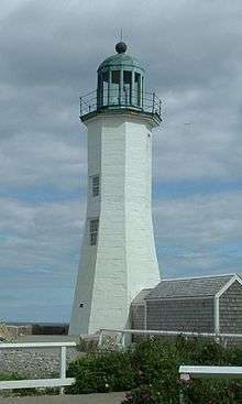 Scituate Lighthouse, Scituate Harbor
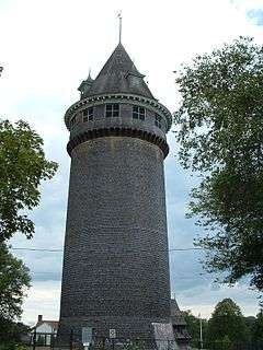 Lawson Tower, Scituate Center
 Minot Ledge Light c. 1905
 Stanley House c. 1905
 Scituate Beach, Massachusetts, Thomas Doughty, 1837
References
- ↑ "Scituate". Dictionary.com Unabridged. Random House. Retrieved November 15, 2014.
- ↑ "Profile of General Population and Housing Characteristics: 2010 Demographic Profile Data (DP-1): Scituate town, Plymouth County, Massachusetts". U.S. Census Bureau, American Factfinder. Retrieved March 21, 2012.
- ↑ http://www.barkertavern.com/history.html
- ↑ "MHC Reconnaissance Survey Town Report SCITUATE" (PDF). Florida Today. Florida Today. 1981. p. 4.
- ↑ The Weekly Press (1894). "A Horror of the Sea" (PDF) (February 14, 1894). The Weekly Press, New York: 1. Retrieved October 8, 2014.
- ↑ Fourth Cliff Mil Res at FortWiki.com
- ↑ "Geographic Identifiers: 2010 Demographic Profile Data (G001): Scituate town, Plymouth County, Massachusetts". U.S. Census Bureau, American Factfinder. Retrieved March 21, 2012.
- ↑ MBTA CBB Greenbush Construction Project website
- ↑ CIS: Unincorporated and Unofficial Names of Massachusetts Communities
- ↑ p. 4, line 20–24.
- ↑ "TOTAL POPULATION (P1), 2010 Census Summary File 1". American FactFinder, All County Subdivisions within Massachusetts. United States Census Bureau. 2010.
- ↑ "Massachusetts by Place and County Subdivision - GCT-T1. Population Estimates". United States Census Bureau. Retrieved July 12, 2011.
- ↑ "1990 Census of Population, General Population Characteristics: Massachusetts" (PDF). US Census Bureau. December 1990. Table 76: General Characteristics of Persons, Households, and Families: 1990. 1990 CP-1-23. Retrieved July 12, 2011.
- ↑ "1980 Census of the Population, Number of Inhabitants: Massachusetts" (PDF). US Census Bureau. December 1981. Table 4. Populations of County Subdivisions: 1960 to 1980. PC80-1-A23. Retrieved July 12, 2011.
- ↑ "1950 Census of Population" (PDF). Bureau of the Census. 1952. Section 6, Pages 21-10 and 21-11, Massachusetts Table 6. Population of Counties by Minor Civil Divisions: 1930 to 1950. Retrieved July 12, 2011.
- ↑ "1920 Census of Population" (PDF). Bureau of the Census. Number of Inhabitants, by Counties and Minor Civil Divisions. Pages 21-5 through 21-7. Massachusetts Table 2. Population of Counties by Minor Civil Divisions: 1920, 1910, and 1920. Retrieved July 12, 2011.
- ↑ "1890 Census of the Population" (PDF). Department of the Interior, Census Office. Pages 179 through 182. Massachusetts Table 5. Population of States and Territories by Minor Civil Divisions: 1880 and 1890. Retrieved July 12, 2011.
- ↑ "1870 Census of the Population" (PDF). Department of the Interior, Census Office. 1872. Pages 217 through 220. Table IX. Population of Minor Civil Divisions, &c. Massachusetts. Retrieved July 12, 2011.
- ↑ "1860 Census" (PDF). Department of the Interior, Census Office. 1864. Pages 220 through 226. State of Massachusetts Table No. 3. Populations of Cities, Towns, &c. Retrieved July 12, 2011.
- ↑ "1850 Census" (PDF). Department of the Interior, Census Office. 1854. Pages 338 through 393. Populations of Cities, Towns, &c. Retrieved July 12, 2011.
- ↑ "American FactFinder". United States Census Bureau. Retrieved 2008-01-31.
- ↑ "Revealed: The most Irish town in America (and it's not Boston or New York)". The Daily Mail Online. November 14, 2011. Retrieved April 26, 2013.
- ↑ Phillips, Frank (January 30, 2013). "William 'Mo' Cowan is Governor Deval Patrick's pick to serve as interim US senator". Boston Globe. Retrieved April 26, 2013.
- ↑ Index of Legislative Representation by City and Town, from Mass.gov
- ↑ "Registration and Party Enrollment Statistics as of October 15, 2008" (PDF). Massachusetts Elections Division. Retrieved 2010-05-08.
- ↑ Marks, Jeffrey A. "No Escape: Jacques Futrelle and the Titanic". Mystery Scene magazine. Retrieved August 17, 2016.
- ↑ Yahoo Movies on Tolan
External links
| Wikimedia Commons has media related to Scituate, Massachusetts. |
| Wikivoyage has a travel guide for Scituate (Massachusetts). |
- Town of Scituate official website
- Scituate Historical Society
- Scituate Community Preservation Committee
- Scituate Town Library
- Page about early settler Walter Woodworth including a map of early Scituate
- Answer Book/Scituate: Everything you need to know
