Schrecksbach
| Schrecksbach | ||
|---|---|---|
| ||
 Schrecksbach | ||
Location of Schrecksbach within Schwalm-Eder-Kreis district 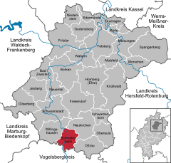
 | ||
| Coordinates: 50°50′N 9°17′E / 50.833°N 9.283°ECoordinates: 50°50′N 9°17′E / 50.833°N 9.283°E | ||
| Country | Germany | |
| State | Hesse | |
| Admin. region | Kassel | |
| District | Schwalm-Eder-Kreis | |
| Government | ||
| • Mayor | Erich Diehl (SPD) | |
| Area | ||
| • Total | 36.61 km2 (14.14 sq mi) | |
| Population (2015-12-31)[1] | ||
| • Total | 3,104 | |
| • Density | 85/km2 (220/sq mi) | |
| Time zone | CET/CEST (UTC+1/+2) | |
| Postal codes | 34637 | |
| Dialling codes | 06698 | |
| Vehicle registration | HR | |
| Website | www.schrecksbach.de | |

Schrecksbach is a community in the Schwalm-Eder district in Hesse, Germany.
Geography
Location
Schrecksbach lies in the southern part of Schwalm-Eder on the River Schwalm, and forms the border with the Vogelsbergkreis.
Constituent communities
The following centres belong to the greater community::
|
|
|
|
History
Schrecksbach is a very old place that was mentioned in one of Charlemagne's documents as "Screggesbaha am Sualmanahafluß" as early as 782.
The community itself was first mentioned in 1223.
On 31 October 1806, Napoleon's army overran the country. Elector William I fled and was unseated. At this time, Schrecksbach was occupied by enemy (ie French) troops, suffering heavily as a result.
Politics
Municipal council
Municipal council is made up of 23 members.
(as of municipal elections held on 26 March 2006)
Economy and infrastructure
Transport
The community is connected to the buslines through the railway stations at Schwalmstadt-Treysa and Alsfeld.
References
- ↑ "Bevölkerung der hessischen Gemeinden". Hessisches Statistisches Landesamt (in German). August 2016.
External links
Towns and municipalities in the district of Schwalm-Eder | ||
|---|---|---|