Schober group
| Schober Group | |
|---|---|
| Schobergruppe | |
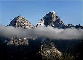
 Karlkamp massif, view from Grossglockner High Alpine Road | |
| Highest point | |
| Peak | Petzeck |
| Elevation | 3,283 m (10,771 ft) |
| Coordinates | 46°56′54″N 12°48′15″E / 46.94833°N 12.80417°ECoordinates: 46°56′54″N 12°48′15″E / 46.94833°N 12.80417°E |
| Geography | |
.png) Schober group (in red) within the Alps. | |
| Country | Austria |
| States | Tyrol and Carinthia |
| Parent range | Hohe Tauern |
The Schober Group (German: Schobergruppe) is a sub-range of the Hohe Tauern mountains in the Central Eastern Alps, on the border between the Austrian states of Tyrol (East Tyrol) and Carinthia. Most of the range is located inside Hohe Tauern national park. It is named after Mt. Hochschober, 3,242 metres (10,636 ft), though its highest peak is Mt. Petzeck at 3,283 metres (10,771 ft).
Geography
The range comprises central parts of the Hohe Tauern south of the neighbouring Glockner Group and the Alpine divide. In the south it stretches down to the East Tyrolean capital Lienz and the Drava Valley. In the east, the Grossglockner High Alpine Road leads up to Hochtor Pass via Großkirchheim.
Subgroups of the High Tauern according to the AVE (from west to east) | ||
|---|---|---|
| Main ridge |  | |
| Southern groups | ||