Schellingwoude
| Schellingwoude | ||
|---|---|---|
| ||
| Coordinates: 52°23′4″N 4°57′58″E / 52.38444°N 4.96611°E | ||
| Country | Netherlands | |
| Province | North Holland | |
| Municipality | Amsterdam | |
Schellingwoude is a former village in the Dutch province of North Holland. It was located in the municipality of Amsterdam, on the northern border of the IJ. It is now a neighbourhood of the city of Amsterdam.
Schellingwoude was a separate municipality between 1817 and 1857, when it was merged with Ransdorp.[1]
History
In order to stop the land loss caused by the Zuiderzee, farmers started around 1200 with the building of De Waterlandse Zeedijk. On this dike the village Schellingwoude was founded. Sources of income were farming and fishing. During the 14th century trade was coming on and became more important in the 16th century, because of the developing of the shipping in this part of Holland. But the competition with Amsterdam was enormous, so the shipping activities got less. In those days Schellingwoude was a village of distinction. For the surrounding villages the administration of justice took place in Schellingwoude. In 1622 the population of Schellingwoude was 1048, in 1809 this number was dropped till 684. The decline in the trade and shipping activities was the main cause of this reduction. The activities that remained were farming, fishing and some industrial activity. In 1800 Schellingwoude had two mills. An important lock, the Oranjesluizen, together with a steam pumping station, was ready in 1872. King Willem III laid the first stone on 29 April 1870. The Oranjesluizen and the Schellingwouder Bridge, built in 1957 over the Buiten-IJ, are two identification marks at the east side of the village.
With the arrival of the Oranjesluizen, Schellingwoude got a boost. The lock created new jobs and new houses were built. The village had about five pubs at that time.
The villages at the Waterlandse Zeedijk were extremely stricken by the flood of 1916 and could not get over on their own strength. In 1921 Amsterdam incorporated the villages Buiksloot, Nieuwendam (with Zunderdorp) and Ransdorp (with Schellingwoude, Durgerdam and Holysloot).
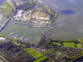 Birdview
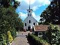 The church of Schellingwoude
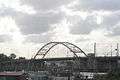 Schellingwouder Bridge
Church
Since the 14th century the village has a church. The Schellingwouder church was built on a terp behind the dyke. The current church is dated from 1866. The church chest from 1659 has survived. Important document were kept in that. The chest has a text engraved in memory of the people of Schellingwoude who stood up for their rights at that time. Other villages required Schellingwoude to pay more money for the upkeep of the Waterlandse Zeedijk. The resistance of Schellingwoude was successful.
Schellinghwoud heeft over vijftigh jaer gestreden
Tegen ses dorpen en twee steden
De gemeendijck versocht en van dat hof verkreghen
In ‘t jaer sestien hondert vijftigh en negen
Nowadays the church does not serve as a house of God anymore. It is a very popular wedding location.
References
- ↑ Ad van der Meer and Onno Boonstra, "Repertorium van Nederlandse gemeenten", KNAW, 2006.
| Wikimedia Commons has media related to Schellingwoude. |
Coordinates: 52°23′N 4°58′E / 52.383°N 4.967°E
Sources:
-"Wijkopbouworgaan Centrale Dorpenraad Landelijk Noord"