Scandrett Regional Park
| Scandrett Regional Park | |
|---|---|
|
Commemorative plaque from 2004 Scandrett Regional Park opening. | |
| Location | North east tip of the Mahurangi Peninsula |
| Nearest city | 82km from Auckland CBD |
| Coordinates | 36°26′35″S 174°46′26″E / 36.443°S 174.774°ECoordinates: 36°26′35″S 174°46′26″E / 36.443°S 174.774°E |
| Area | 44.4 hectares or 100 acres |
| Created | 26 September 2004 |
| Operated by | Auckland Council |
| Open |
Pedestrian access: Open 24 hours Summer gate opening hours: 6:00 a.m. - 9:00 p.m. (Daylight savings) Winter gate opening hours: 6:00 a.m. - 7:00 p.m. (Non daylight savings) |

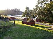
Scandrett Regional Park is a regional park located on the north east tip of the Mahurangi Peninsula, north of the city of Auckland, New Zealand. It encompasses Mullet Point and includes regenerating coastal forest, rocky headlands that protrude into Kawau Bay, Scandretts Bay beach and a precinct of historic farm buildings.[1] The total area of land is 44.4 hectares or 100 acres. The people of Auckland own the park through the Auckland Council.[2][3][4]
History
The Mullet Point area was known to Māori as Purahurawai “the expansive, sparkling waters”. Māori came from throughout the Hauraki Gulf to Kawau Bay (off Mullet Point) to catch and dry sharks for a winter food source. There are a number of sites of past Māori settlement within Scandrett Regional Park, including two headland pā.[2]
The land was the site of early shipbuilding during the 1850s and 1860s.[2]
In 1864, the land was sold to George Scandrett and John Braithwaite settlers of Kawau Island, with Sir George Grey putting up part of the funding. Scandrett had arrived the year before from Northern Ireland and he married Helena Dillon in the same year as he bought the farm.[5]
Scandrett named the farm Lisadian after his hometown in Ireland and gradually brought it into production. In the 1870s, a Norfolk pine, which as of 2011 is still growing on the park,[4] and oak trees, gifts from Sir George Grey were planted on the property. At first, the family lived in a wooden house on the farm before moving into the present concrete house which was built around 1885 and is made of an early type of concrete instead of kauri timber.[4][5] The original invoice for the house was discovered and is being preserved by the council with a copy on display at the farm.[6] The cost of the home and some additional work on other buildings was 418 pounds and 6 shillings or the equivalent of $NZD 474,000 in 2010.[6]
One of George and Helena’s nine children, Thomas was born in 1876. In turn, he became a successful farmer and an orchardist supplying quantities of fresh fruit, vegetables, milk and meat to the surrounding districts. Fruit, honey, eggs and wool were all marketed under the Lisadian label.[5]
When Thomas died in 1926, his sons George (III), aged 17, and Raymond, aged 13, helped their mother Lucy run the farm. In 1951 they took over management of the property and farmed as Scandrett Brothers.[5][7]They also ran Scandretts Bay as a private camping ground for almost 50 years until the Auckland Regional Council (ARC) bought the property and the caravan site leases were withdrawn, with bach leases also gradually running out.[4][7] Raymond who died in 1993, was the last Scandrett to live permanently in the concrete house.[5]
In 1998, the property was purchased by the ARC for use as a regional park. At the time of purchase, there was a near complete collection of farm buildings dating from the 1880s or earlier, including the homestead, a barn, boatshed, cow shed, implement shed, tractor shed and a henhouse / calf shed. In the past, whenever a farm has been purchased for use as a regional park, there has been a tendency for the old farm buildings to be demolished except for the farmhouse. In the case of Scandtrett’s farm, however, the heritage division of the ARC saw all the buildings retained and preserved.[5] Three 40s-style baches were also restored for rental. Two had been previously owned by Geoff Moon and the family of Trelise Cooper.[4]
Prior to most of the Scandrett baches being removed, the motion picture Rain was filmed on the property in 2000 with the coastal beach replacing Lake Taupo which was the setting of the novel the film was based upon.[8]
Scandrett Regional Park was opened by Prime Minister Helen Clark on 26 Sept 2004.[7][9]
The ARC received a New Zealand Institute of Architects heritage award in 2007 for the conservation work done on the farm buildings.[10] In 2011 interpretive panels were installed in the old homestead on topics such as information about Scandrett family members who lived on the farm, the buildings and architecture, and about historical food production.[11][7]
|


References
- ↑ New Zealand By Charles Rawlings-Way, Lonely Planet
- 1 2 3 "Auckland Council Website". Auckland Council. Retrieved 2 September 2013.
- ↑ "Auckland Council Website". Auckland Council. Retrieved 11 September 2013.
- 1 2 3 4 5 "New Zealand Herald Website". New Zealand Herald. 3 December 2011. Retrieved 11 September 2013.
- 1 2 3 4 5 6 "Scandretts Farm, Maurangi Peninsula" (PDF). National Historic Heritage Workshop 2004, Department of Conservation (New Zealand), New Zealand Historic Places Trust and Institution of Professional Engineers New Zealand. Retrieved 18 September 2013.
- 1 2 Restored invoice uncovers history of homestead NZ Local
- 1 2 3 4 "Scandrett Regional Park Interpretive Panels". Michelle Edge, Auckland Council. Retrieved 17 October 2013.
- ↑ "Rain Press Kit". New Zealand Film Commission. Retrieved 18 September 2013.
- ↑ "History on the land as ARC opens newest regional park.". Rodney Times. Retrieved 19 September 2013.
- ↑ Scandrett Regional Park on show NZ Local
- ↑ Scandrett history an easy read NZ Local