Sawel Mountain
| Sawel | |
|---|---|
| Samhail or Samhail Phite Méabha | |
 Sawel as seen from the southeast. Photo taken 22 July 2007. | |
| Highest point | |
| Elevation | 678 m (2,224 ft) |
| Prominence | 657 m (2,156 ft) |
| Listing | Marilyn, Hewitt |
| Naming | |
| Translation | likeness to Meabh's vulva (Irish) |
| Geography | |
 Sawel Location in Ireland | |
| Location | County Londonderry/County Tyrone,[1] Northern Ireland |
| Parent range | Sperrins |
| OSI/OSNI grid | H618973 |
| Topo map | OSNI Discoverer Series 13 The Sperrins (1:50000), OSNI Activity Map Sperrins (1:25000) |
Sawel Mountain (from Irish: Samhail Phite Méabha, meaning "likeness to Meabh's vulva")[2][3] is a mountain in County Londonderry and County Tyrone, Northern Ireland.
Etymology
The Irish name of the mountain, Samhail Phite Méabha, is a reference to a glen or hollow on the side of Sawel.[2][3] It was also historically called Slieve Sawel,[4][5][6] 'Slieve' being an anglicization of Sliabh ("mountain").
Geography
The mountain is the highest peak in the Sperrin Mountains, and the 8th highest in Northern Ireland. To the north of Sawel is County Londonderry, and to the south, County Tyrone. The summit is 678 metres (2,224 ft) and is composed of crystalline limestone.[7][8] Around the peak, there is "montane heathland", with plant life including heather, bilberries and cowberries, although this is being damaged by hillwalking and grazing.[9] Sawel is the source of the River Faughan, a 29 miles (47 km) long tributary of the River Foyle.[10]
See also
References
- ↑ Marshall, David (2006). Best Walks in Ireland. Frances Lincoln Publishers. p. 340. ISBN 978-0-7112-2420-9. Retrieved 2009-01-19.
- 1 2 MountainViews
- 1 2 Mills, A. D. (2003). A Dictionary of British Place-Names. Oxford University Press. Retrieved 2009-01-19.
- ↑ Cahill, Jane (1987). Northern Ireland. Chelsea House Publishers. p. 12. Retrieved 2010-08-01.
- ↑ Wade, Herbert (1922). The New International Encyclopaedia. Dodd, Mead & Co. p. 617. Retrieved 2010-08-01.
- ↑ Chambers's Encyclopaedia: Volume 9. W. and R. Chambers. 1867. p. 618. Retrieved 2010-08-01.
- ↑ Somerville, Christopher (2008-09-25). "Sperrin Hills: walk of the month". Daily Telegraph. Retrieved 2009-01-19.
- ↑ "Sperrin Mountains". Encyclopaedia Britannica. Retrieved 2009-01-19.
- ↑ "Wildlife Action in Derry~Londonderry" (PDF). Derry City Council. 2008. Retrieved 2009-01-19.
- ↑ Starrett, Ian (2000-10-12). "Preserving McGilloway's ways". News Letter. Retrieved 2009-01-19.
Mountains and hills of Ulster | ||
|---|---|---|
| Antrim Hills | 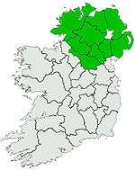 | |
| Antrim Plateau | ||
| Belfast Hills | ||
| Croaghgorms | ||
| Derryveagh | ||
| Inishowen | ||
| Mournes | ||
| Sperrins | ||
| Southwest Donegal | ||
| Others | ||
Coordinates: 54°49′N 7°02′W / 54.817°N 7.033°W