Sawatch Range
| Sawatch Range | |
|---|---|
| Saguache Range | |
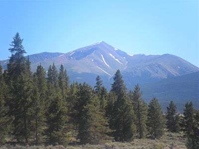
 Sawatch Range seen from Monarch Pass | |
| Highest point | |
| Peak | Mount Elbert |
| Elevation | 14,440 ft (4,401 m) |
| Coordinates | 39°07′03.9″N 106°26′43.29″W / 39.117750°N 106.4453583°WCoordinates: 39°07′03.9″N 106°26′43.29″W / 39.117750°N 106.4453583°W |
| Dimensions | |
| Length | 80 mi (130 km) NW/SE |
| Geography | |
| Country | United States |
| State | Colorado |
| Parent range | Rocky Mountains |
The Sawatch Range /səˈwætʃ/[1][2] is a high and extensive mountain range in central Colorado which includes eight of the twenty highest peaks in the Rocky Mountains, including Mount Elbert, at 14,440 feet (4,401 m) elevation, the highest peak in the Rockies.
The range is oriented along a northwest-southeast axis, extending approximately 80 miles (130 km) from 39°37′36″N 106°32′13″W / 39.62667°N 106.53694°W in the north to 38°5′51″N 106°3′48″W / 38.09750°N 106.06333°W in the south. The range contains 15 peaks topping 14,000 feet (4,267 m), also known as 14ers. The range forms a portion of the Continental Divide, and its eastern flanks are drained by the headwaters of the Arkansas River. The western side of the range feeds the headwaters of the Roaring Fork River, the Eagle River, and the Gunnison River, tributaries of the Colorado River.
The Sawatch mountains in general are high, massive, and relatively gentle in contour. While some peaks are rugged enough to require technical climbing, most can be climbed by a simple, yet arduous hike. Notable summits include Mount Elbert, Mount Massive, La Plata Peak, Mount of the Holy Cross, and the Collegiate Peaks (Mounts Columbia, Harvard, Princeton, Yale, Belford, and Oxford).
State Highway 82 traverses the range at Independence Pass (Colorado). It is also traversed by Cottonwood Pass, which connects the town of Buena Vista with Gunnison County. Both Independence Pass and Cottonwood Pass are over 12,000 feet (3,658 m), making them 2 of the highest passes in Colorado and are typically open only from late spring to mid autumn. Hagerman Pass is another pass to the north, connecting the Arkansas Headwaters near Leadville with the upper valley of the Fryingpan River. Hagerman pass is traversable with four-wheel drive vehicles and on foot during summer and early autumn months. The range contains numerous hiking trails within the San Isabel National Forest and White River National Forest.
Prominent peaks

| Rank | Mountain Peak | Elevation | Prominence | Isolation |
|---|---|---|---|---|
| 1 | Mount Elbert[3] NGS | 14,440 feet 4401 m |
9,093 feet 2772 m |
670.6 miles 1079.2 km |
| 2 | Mount Massive[4] | 14,428 feet 4398 m |
1,941 feet 592 m |
5.1 miles 8.2 km |
| 3 | Mount Harvard NGS | 14,421 feet 4395 m |
2,327 feet 709 m |
14.9 miles 24.0 km |
| 4 | La Plata Peak[4] | 14,343 feet 4372 m |
1,841 feet 561 m |
6.3 miles 10.1 km |
| 5 | Mount Antero NGS | 14,276 feet 4351 m |
2,503 feet 763 m |
17.7 miles 28.6 km |
| 6 | Mount Princeton NGS | 14,204 feet 4329 m |
2,177 feet 664 m |
5.2 miles 8.4 km |
| 7 | Mount Yale NGS | 14,202 feet 4329 m |
1,876 feet 572 m |
5.5 miles 8.9 km |
| 8 | Mount of the Holy Cross NGS | 14,011 feet 4271 m |
2,111 feet 643 m |
18.5 miles 29.8 km |
| 9 | Grizzly Peak NGS | 13,995 feet 4266 m |
1,908 feet 582 m |
6.8 miles 10.9 km |
| 10 | Mount Ouray NGS | 13,961 feet 4255 m |
2,659 feet 810 m |
13.6 miles 21.9 km |
| 11 | Mount Jackson[4] PB | 13,676 feet 4169 m |
1,810 feet 552 m |
3.2 miles 5.2 km |
| 12 | Bill Williams Peak[4] PB | 13,389 feet 4081 m |
1,682 feet 513 m |
4.0 miles 6.5 km |
| 13 | Antora Peak[4] PB | 13,275 feet 4046 m |
2,409 feet 734 m |
6.7 miles 10.9 km |
| 14 | Henry Mountain[4] PB | 13,261 feet 4042 m |
1,674 feet 510 m |
11.5 miles 18.6 km |
| 15 | Park Cone[4] PB | 12,106 feet 3690 m |
2,040 feet 622 m |
3.4 miles 5.5 km |
| 16 | Red Table Mountain[4] PB | 12,043 feet 3671 m |
2,017 feet 615 m |
10.3 miles 16.6 km |
| 17 | Tomichi Dome[4] PB | 11,471 feet 3496 m |
2,325 feet 709 m |
13.3 miles 21.4 km |
| 18 | Castle Peak[4] PB | 11,285 feet 3440 m |
3,040 feet 927 m |
18.9 miles 30.5 km |
See also
References
- ↑ The place name "Sawatch" is pronounced /səˈwætʃ/. This name derives from the Ute language noun "sawup" /səˈwʌp/ meaning "sand dunes". The Spanish language version of this name is usually spelled "Saguache", while the English language version is usually spelled "Sawatch".
- ↑ Merkl, Dameon (February 26, 2013), "What's in a Colorado name pronunciation?", The Denver Post, retrieved March 7, 2013
- ↑ The summit of Mount Elbert is the highest point of the Rocky Mountains and the State of Colorado.
- 1 2 3 4 5 6 7 8 9 10 The elevation of this summit has been converted from the National Geodetic Vertical Datum of 1929 (NGVD 29) to the North American Vertical Datum of 1988 (NAVD 88). National Geodetic Survey
External links
| Wikimedia Commons has media related to Sawatch Range. |
- Sawatch Range @ Peakbagger
- Sawatch Range @ 14ers.com
- Sawatch Range @ summitpost.org
- Mt. Aetna @ summitpost.org
