Sawahlunto
| Sawahlunto | ||
|---|---|---|
| City | ||
| Other transcription(s) | ||
| • Jawi | ساواهلونتو | |
|
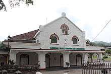
Grand Mosque of Sawahlunto | ||
| ||
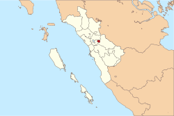 Location of Sawahlunto in Indonesia | ||
 Sawahlunto Location of Sawahlunto in Indonesia | ||
| Coordinates: 0°40′S 100°47′E / 0.667°S 100.783°E | ||
| Country | Indonesia | |
| Province | West Sumatra | |
| City Established | 1 December 1888 | |
| Government | ||
| • Mayor | Ir. H.Amran Nur | |
| Area | ||
| • Total | 275.86 km2 (106.51 sq mi) | |
| Population (2014) | ||
| • Total | 59,821 | |
| • Density | 220/km2 (560/sq mi) | |
| Time zone | WIB (UTC+7) | |
| Area code(s) | +62 754 | |
| Climate | Af | |
| Website | www.sawahluntokota.go.id | |


Kota Sawahlunto or Sawah Lunto (Jawi: ساواهلونتو) is a town in West Sumatra, Indonesia, 90 kilometres from Padang. The town itself covers 5.9 km² and has a population of 15,279. The city of which the town is the central part covers 276 sq. km, and had a population of 59,821 in 2014.
Sawahlunto is one of the mining towns in West Sumatra. It was first established as a town in 1882 by the Dutch along with coal mining operations. Coal was discovered in the mid-19th century by Ir. de Greve. It was then suggested to the Dutch that coal should be mined in the area because coal was needed for industry and transportation. After the discovery of coal the area was frequently visited by geologists. Coal mining was pioneered in the area after the eventual "surrender" of the area to the Dutch in 1876.
- In 1888 the Nederland Indies initialised many coal mining facilities
- In 1894 train tracks were opened
- In 1898 the first coal mining tunnel was built at Air Dingin, Lembah Segar, but was later closed in 1932 and re-opened again in June 2007.[1]
Mining was initiated in the area after Independence. Activities were undertaken by PT Tambang Batubara Ombilin (TBO). PT TBO was later liquidated and became a subsidiary of PTBA (Bukit Asam) which is located in Southern Sumatra. Since reforms in the region, the area has experienced a growth in mining community because people felt compelled to participate in coal mining. Coal mining was not restricted within the boundaries of the community but also extended to the land owned by PTBA TPO. The mayor at that time was Ir. Amran Nur, with Erizal Ridwan S.T. as his representative.[2]
After golden period of mining and mine sites closed, Sawah Lunto became a ghost town and the population declined. In 2004, Sawah Lunto policy is to make Sawah Lunto as a tourist city and then population inclined. In 2014, 29 percent income came from tourism, while from farming only got 23 percent.[3]
Administrative divisions
Sawahlunto was also known as a mining town with a geographical size of 27 Ha or 273.45 km². Administratively Sawahlunto is divided into 4 districts, 10 sub districts and 27 villages (desa) and 95 km away from Padang (capital of West Sumatra). It is a 2-hour drive from Padang.
Sawahlunto has a maximum elevation of about 650m above sea level. The landscape is primarily made up of steep hills which act as a hindrance to the development of the town. The old town centre spanned 5.8km2. Relatively flat lands can be found in Kecamatan Talawi district. The area that runs from north to south has a relatively steep topography at an angle of elevation of approximately 40%. On the other hand, the northern area is relatively gentle sloping. Most developments is located at as height of 100-500m. Development consists of both protected areas (25%) as well as areas set aside for cultivation (73%). This land mainly consists of mixed gardening(34%), thick forest and scrub(19%). 0.2% of the lake was once used for mining.
Climate
Similar to other areas in West Sumatra, the town of Sawahlunto has a tropical climate with temperatures fluctuating around 22 °C. The area experiences two seasons throughout the year whereby the monsoon season takes place from November to June while dry spells occur over the period of July to October. They experience approximately 1.072 mm of rainfall per year with the wettest month being December.
Population
As of 2013 the total population of Sawahlunto stood at around 53,660, consisting of 25,900 males and 27,760 females.
Their source of income varies from working on farms to mining and service sector. The economic structure of the people of Sawahlunto is mainly supported by mining. Subsectors consists of agriculture, small industries/handicrafts and livestock farming.
With the expansion of the district based on the government law No.44, 1990 Sawahlunto became known not only for handicrafts, snacks, livestock and fruits, but also as a tourist destination.
Geography
Geographically Sawahlunto is located at 033’40" – 043’ 33" South and 100 43’ 13" – 100 50’ 40" East, bounded from the north by Tanah Datar district, the east by Sawahlunto/Sijunjung district and the south by Solok district.
History

Sawahlunto is one of the many towns located in the area of Bukit Barisan West Sumatra, but with a history different from the other towns.
Towns such as Bukittinggi, Batusangkar, Payakumbuh, Padang Panjang and Solok is shaped by the Minang community, while Sawahlunto, by the mining business during the colonisation of the Dutch in 1888. Sawahlunto started becoming a residential area for coal miners when the Dutch Indies government invested 5.5 million [gulden] (the Dutch currency at that time) to build various facilities to manage the coal mining industry Ombilin. This residential area continued to expand to become a small town which consisted mainly of officers and coal miners.
The Dutch also built a train system costing 17 million gulden as a mode for coal to be transported out from Sawahlunto through Padang. Trains have been in operation since 1888 but only recently reached Muara kalaban and later on reaching Sawahlunto in 1894. Having trains as a mode of transport brought in huge profits from the investment from only tens of thousands to hundreds of thousands tons of coal per year. Losses turned into big profits as much as 4.6 million gulden in a year in 1920. Until 1898, the coal mining business still used forced labour, known as narapaidana, who were forced to work with minimum wage. In 1908 wages for forced labour was 18 cents/day and they were subjected to whips under legal sanctions should they rebel. Wages for contract workers were 32 cents/day and they were entitled to housing facilities and healthcare facilities. Meanwhile, wages for other labourers were 62 cents/day without benefits (Zubir,1995). With that, you can picture Sawahlunto to be a prisoner camp for the forced workers in the early 20th century.
In 1918 Sawahlunto was known as Gemeentelijk Ressort or Gemeente with a land area of 778 ha. The name was given to mark its success in coal mining activities at that time. The total population in 1930 was 43,576 consisting of 564 Europeans. Even though Sawahlunto had yet to become Stadsgemeente, the management of the town was done by Stadsgemeenteraad (DPRD) and Burgemeester (Walikota).
Globally, since 1940 till end 70s the production of coals Ombilin declined, and returned only tens of thousands of tons per year. Sawahlunto also faced a decline in coal production indicative of the decline in population to only 13,561 inhabitants in the 1980. With the increased number of facilities, a change in management and the application of new technology, the mining industry increased again since the beginning of the 80s. Moreover, production continued to increase even exceeding 1 million tonnes per year in the late 90's. The population in Sawahlunto increased to 15,279 according to the Census in 1990. Even though the population growth rate is only 1.2%, it is still below the annual average population growth rate of Sumatera Barat which reached 1.62% and did not appear correlated with increased production of coal.
On 10 March 1949, a meeting was held between Afdeeling Solok, which is supervised by Sawahlunto/Sijunjung and Kabupaten Solok, under the governance of Stad Gemeente Sawahlunto, which is under the authority of Bupati Sawahlunto/Sijunjung to discuss on the natural resources gained . In the period 1949 - 1965 there were changes in the governance of Sawahlunto/Sijunjung. The status of Act No. 18 in 1965 changed to Regional Level II with the title as Kotamadya Sawahlunto commanded by the town, Mayor AKHMAD Noerdin, as of 11 June 1965, with the Decree of the Minister of Home Affairs dated 8 March 1965. The act in Item Number Up 1965. 15/2/13-227 stated the responsibility of the Mayor as the Head of the Regional Sawahlunto.
Mayors
Mayors who have led the town of Sawahlunto since the its inauguration to date are as follows:
- Achmad Nurdin, SH (Term of office 1965 s/d 1971)
- Drs. Shaimoery, SH (Term of office 1971 s/d 1983)
- Drs. Nuraflis Salam (Term of office 1983 s/d 1988)
- Drs. H. Rahmatsjah (Term of office 1988 s/d 1993)
- Drs. H. Subari Sukardi (Term of office 1993 s/d 1988 and Term of office 1988 s/d 2003)
- Ir. H. Amran Nur (Term of office 2003 S/D 2008) and H. Fauzi Hasan (Term of office, representative 2003 S/D 2008)[4]
- Ir. H. Amran Nur (Term of office 2008 S/D 2013) and H. Erizal Ridwan, ST (Term of office, representative 2008 S/D 2013)
- Ali Yusuf, S.Pt. (Term of office 2013 S/D 2018) and Ismed, S.H. (Term of office, representative 2013 S/D 2018)
Recent developments
In 1990 the administration district of Sawahlunto was expanded from only 779ha to 27,344ha which brought about an increase in population. Based on the results of the Census survey conducted with the residences in 1995, the population in Sawahlunto reflected to have increased to 55,090 people even though the land area of Sawahlunto remained the same unlike how towns would generally expand in proportion to the population growth. Due to its landscape, the expansion of Sawahlunto became a form of federation of small towns and rural settlements. However,based on the Census in 2000 the growth of its people was proven to be temporary, as the population of Sawahlunto appeared to be declining. Based on the same Census, it was stated that the total population was 50,668 people, which translates to a decline of 8% over a span of 5 years. One of the reasons for this was that a portion of the employee housing of the Ombilin Coal Mining Unit (UPO) was shifted out of the town area of Sawahlunto. From this aspect, it is obvious that Ombilin coal mining has a very strong influence on Sawahlunto.
Over the course of 100 years, the amount of coal exploited has reached approximately 30 million tonnes with remaining reserves of more than 100 million tonnes. However the future of the coal mining industry in Ombilin is now unclear due to reserves which can only be exploited internally. Whether or not these reserves will be exploited depends on the market price as well as market demand for coal and technological advancements. In addition, the implementation of coal mining is also facing a re-orientation due to its decentralised expansion. Regardless, the government and people of Sawahlunto are determined to make Sawahlunto a tourist destination with mining as an attraction. This reflects the new relationship between mining Ombilin and town of Sawahlunto which can be further developed.
In recent years, policy of the Sawahlunto municipal administration has been directed towards the twin goals of promoting structural adjustment in the local economy and tackling poverty. Structural adjustment measures have been implemented with the aim of transforming the city from being a coal town towards strengthening the tourist sector. To address poverty, the government has implemented a detailed poverty eradication program which focuses on agriculture, plantations, and the livestock sector. The measured level of poverty has fallen rapidly in recent years from over 17% in 2005 to under 3% in 2009.[5]
The date of 1 December 1888 marked the inauguration of the town of Sawahlunto. The inauguration has been commemorated annually since 2005 with a traditional makan bajamba along the stretch of Pasar Remaja Kota Sawahlunto.
References
- ↑ "Nuansa Hollywood di Kota Sawahlunto". 15 March 2012.
- ↑ Well-known public figure and author, Jusuf Wanandi, who was born in Sawahlunto, provides details of Mayor Amran's activities as well as an account of the growth of Sawahlunto in Jusuf Wanandhi, 'Sawahlunto: A Model of hope for Indonesia's future', The Jakarta Post, 5 October 2012.
- ↑ Hans david Tampubolon (5 September 2014). "Sawahlunto: A small town that dreams big".
- ↑ Ika Krismantari, 'Amran Nur: Doing it for Sawahlunto', The Jakarta Post, 28 September 2012.,
- ↑ Syofiardi Bachyul jb,Future, jobs, happiness: Eradicating poverty the Swahlunto way', The Jakarta Post, 22 November 2012.
External links
| Wikimedia Commons has media related to Sawahlunto. |
- (Indonesian) Official site

Coordinates: 0°40′S 100°47′E / 0.667°S 100.783°E