Savannakhet Province
| Savannakhet ສະຫວັນນະເຂດ | |
|---|---|
| Province | |
|
A restaurant on the Mekong | |
 Map of Savannakhet Province | |
 Location of Savannakhet Province in Laos | |
| Coordinates: 16°32′N 105°47′E / 16.54°N 105.78°ECoordinates: 16°32′N 105°47′E / 16.54°N 105.78°E | |
| Country |
|
| Capital | Savannakhet |
| Area | |
| • Total | 21,774 km2 (8,407 sq mi) |
| Population (2015 census) | |
| • Total | 969,697 |
| • Density | 45/km2 (120/sq mi) |
| Time zone | UTC+07 |
| ISO 3166 code | LA-SV |


Savannakhét (Lao:ສະຫວັນນະເຂດ) is a province of Laos. The name derives from Savanh Nakhone ("city of paradise" or "land of fertility suitable for agriculture") the province's original name. It bears the same meaning as Nakhon Sawan, a city in Thailand.
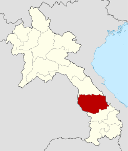
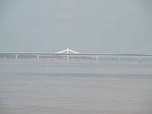
The province is located in the southern part of the country and is the largest province in Laos. It borders Khammouane Province to the north, Quảng Trị and Thừa Thiên–Huế provinces of Vietnam to the east, Salavan Province to the south, and Nakhon Phanom and Mukdahan provinces of Thailand to the west. The Second Thai–Lao Friendship Bridge over the Mekong connects Mukdahan Province in Thailand with Savannakhet in Laos. Its capital, Savannakhet, also known as Kaysone Phomvihane or Muang Khanthabouly is Laos' second most notable city after Vientiane. It forms an important trading post between Thailand and Vietnam.
Along with Bolikhamsai and Khammouane, Savannakhét Province is one of the main tobacco producing areas of Laos. It has numerous natural resources. Sepon is the largest mine in Laos, with reserves of copper and gold.
History
Prehistoric human occupation is evidenced by the first stone tools in the province, dating back between 100,000 and 12,000 years. The first bronze tools date to 2000 BCE. The region was then the center of the Sikhottabong Kingdom. The much-venerated Pha That Sikhottabong stupa is situated on the grounds of a 19th-century monastery in Thakhek.[1] Sikhottabong was an important kingdom in ancient Indo-China.[2] Its capital was in the north-west of the province, in the present village of Meuang Kabong, on the eastern shores of the Banghiang River, about 10 kilometres (6.2 mi) east of the Mekong. Other centers of the kingdom were in Viang Chan, Khammuan, Nong Khai, and Udon.[2] Khmer Empire ruins dating to AD 553 and 700 have been found at Heuan Hin.[3]
In the 20th century, Savannakhet province was one of the seats of the struggle for independence. Prime Minister Kaysone Phomvihane originated in the province.[4] The town was bombed and then occupied by Thai armed forces during the Franco-Thai War. During the Vietnam War, the eastern part of the province was crossed by the Ho Chi Minh trail. It was heavily bombed by U.S. forces and loyalists. Some areas are still under the threat of unexploded ordnance. In 2007, the Second Thai–Lao Friendship Bridge was opened across the Mekong from Savannakhet to Mukdahan, Thailand. In April 2008, a chance discovery was made at Meuang Kabong consisting of 8.5 kilograms (19 lb) of gold and 18.7 kilograms (41 lb) of silver objects, as well as pillars and traces of brick walls. Many missionaries came here; a Catholic church is located in Savannakhet.[5]
Geography
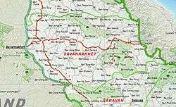
Savannakhet Province one of the province of Laos,[6] is the largest province, covering an area of 21,774 square kilometres (8,407 sq mi).[7][8] The province borders Khammouan Province to the north, Quảng Trị and Thừa Thiên–Huế provinces of Vietnam to the east, Salavan Province to the south, and Nakhon Phanom and Mukdahan provinces of Thailand to the west. Notable settlements in the province include Savannakhet, Muong Song Khone, Ban Nhiang, Seno, Dong-Hen, Muang Phalan, Ban Sanoun, Muang Phin, Ban Dong, Ban Nammi, Ban Nao Tai.[9]
The Second Thai–Lao Friendship Bridge over the Mekong connects Mukdahan Province in Thailand with Savannakhet in Laos. The bridge is 1,600 metres (5,200 ft) long and 12 metres (39 ft) wide, with two traffic lanes.[10]
Protected areas
Areas under protection in the province include Xe Bang Nouan National Biodiversity Conservation Area to the south, Dong Phou Vieng National Protected Area to the southeast, and Phou Xang He National Protected Area to the north. Phou Xang He has rocky mountain ranges, and is known for local Puthai culture. The Dong Phou Vieng is known for its ancient forest with tall vegetation, a sacred lake and That Ing Hang Stupa; there are endangered Eld's deer, silver langurs and hornbills which are rarely found in other reserves.[11]
Administrative divisions
The largest province in Laos is made up of the following 15 districts:[7]
| Map | Code | Name | Lao |
|---|---|---|---|
 | |||
| 13-01 | Kaysone Phomvihane, former Khanthabouly | ||
| 13-02 | Outhoumphone | ||
| 13-03 | Atsaphangthong | ||
| 13-04 | Phine | ||
| 13-05 | Sepone | ||
| 13-06 | Nong | ||
| 13-07 | Thapangthong | ||
| 13-08 | Songkhone | ||
| 13-09 | Champhone | ||
| 13-10 | Xonnabouly | ||
| 13-11 | Xaybuly | ||
| 13-12 | Vilabuly | ||
| 13-13 | Atsaphone | ||
| 13–14 | Xayphouthong | ||
| 13–15 | Phalanxay | ||
Demographics
The population of this largest province of Laos is 825,879 as of the March 2005 census,[12] spread over 15 districts. The ethnic minority groups residing in the province include Lao Loum, Phu Tai, Tai Dam, Katang, Mongkong, Vali, Lavi, Souei, Kapo, Kaleung and Ta Oi.[7] However, in the 2000 census, only three ethnic groups were listed: Lao Loum (Lowland Lao), Phu Tai, and Bru,[13] the only ones recognized by the provincial government. The Bru, however, are a diverse people with various dialects and cultures.[14]
Economy
Sepon mine, situated about 250 miles (400 km) southeast of Vientiane, is the largest mine in Laos, with reserves of copper and gold.[15] In the 1980s, Laotians panned for gold here using pieces of shrapnel and aircraft wreckage.[16] Early exploration occurred in 1990 by Australian mining company CRA, which was subsequently awarded a contract. It is now operated, and 90% owned by MMG Limited.[17][18] Sepon became the country's first significant foreign mining interest when it opened in 2002.[16] Other mining companies operating in the province (2008) include: Wanrong Cement III, Lane Xang Minerals LTD (Vilabuly District), Lane Xang Minerals Ltd (Vilabuly District), Lao State Gypsum Mining Co Ltd (Champhone District), and Savan Gypsum Mining Co. (Champhone District).[15] Along with Bolikhamsai and Khammouane provinces, it is one of the main tobacco producing areas of Laos.[19]
Landmarks
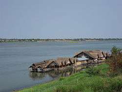
Apart from the provincial capital, Savannakhet, which is a trading centre opposite to Mukhdahan town in Thailand, other places of interest in the town area are the Roman Catholic Church, a Vietnamese temple and school. Most of the buildings in the town are in the French architectural style of their colonial rule.[8] In the Ban Nonglamchan Village in Champhone District, there is a library which contains a collection of manuscripts written in the Kham-Pali and Lao languages on palm leaves which are stated to be 200 years old. In Ban Tangvay Village of Xonbuly District, fossilized dinosaur bones found in 1930 are exhibited in the Dinosaur Exhibition Hall in Savannakhet. The Ho Chi Minh trail and remnants of American tanks and warplanes are on display in Phin District on Route 9, near the Lao Bao border check post.[7]
- Fossil sites
There are five fossil sites in the province.[20] The best known of the Cretaceous fossil sites is that of Tang Vay, 120 kilometres (75 mi) northeast of Savannakhet, which dates to 110 million years ago. The site was discovered by the geologist Josué Hoffet in 1936 and was explored by a team led by Philippe Taquet from the Muséum national d'histoire naturelle of Paris in the 1990s. He discovered tree fossils (Araucarioxylon hoffetti), turtles, and a sauropod, Tangvayosaurus hoffetti.[21] Aptian age findings include a Psittacosaurus. In Pha Lane, on the banks of the Sê San River, a theropod was discovered.
- Museums
Fossils are exhibited in a dinosaur museum in Savannakhet.[22] The Savannakeht Provincial Museum[22] has exhibits of war relics, artillery and inactive UXOs. Museum exhibits include three small bowls (diameter 50 centimetres (20 in)) and two large (diameter of 1 metre (3 ft 3 in) or more), seriously damaged but decorated, discovered in the district of Sepon (2001) and along the banks of the Mekong (2008). Their handles imitate basketry. The Dong Son culture is represented by several bronze drums.
- Religious sites
The Wat Inghang temple, about 2000 years old, is located in the Ban Thad village. It was built to commemorate a visit of Lord Buddha when he was the guest of King Sumitatham of the Sikhottabong Kingdom. King Saysethathirath had the temple remodeled during 1548. It is approached by Route 9 between Savannakhet and Seno. An annual festival is held here on the first full moon of the lunar calendar.[7]
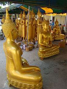
The Wat Xayaphoum temple was built in 1542 in Xayaphoum village on the bank of the Mekong River during the period when Ban Thahir or Nakham temple was built. As the Buddhist centre and largest monastery in Laos, its arts and architecture are dated to the earliest Savannakhet period. The temple has a large garden with ancient trees surrounding it. There is also a workshop near the entrance from the river side where golden Buddha statues are made.[20] Pimai Lao festival is held in the province and boat racing is an important event.[7]
Heuan Hin ("stone house") is a shrine in Ban Dongdokmay. It was built during the Khmer regime in honour of their Sikhottabong Kingdom. The stone house is located 15 kilometres (9.3 mi) from Xayphouthong District, or 66 kilometres (41 mi) from Khanthabuly.[7]
The That Phon Stupa was built during the period of 557 to 700. The festival held here during the first full moon of the lunar calendar marks tribute to Phra Sghiva and some Hindu gods.[7]
St Teresa's Catholic Church is situated in Savannakhet's main square. Built in 1930, it consists of thick masonry walls and an octagonal spire.[5]
References
- ↑ "Pha That Sikhottabong". Lonely Planet/BBC Worldwide. Retrieved 12 December 2012.
- 1 2 Rasdavong, Khamyad (2006). The history of Buddhism in Laos. Lao Front for National Construction, Central Committee. pp. 25, 27, 29. Retrieved 11 December 2012.
- ↑ Bush, Austin; Elliot, Mark; Ray, Nick (1 December 2010). Laos 7. Lonely Planet. pp. 261–. ISBN 978-1-74179-153-2. Retrieved 11 December 2012.
- ↑ Rough Guides (15 November 2010). The Rough Guide to Southeast Asia On A Budget. Penguin. pp. 436–. ISBN 978-1-4053-8686-9. Retrieved 11 December 2012.
- 1 2 Cranmer, Jeff; Martin, Steven; Coxon, Kirby (1 November 2002). Laos. Rough Guides. pp. 268–. ISBN 978-1-85828-905-2. Retrieved 11 December 2012.
- ↑ "Home". Regions. Official website of Laos Tourism. Retrieved 7 January 2013.
- 1 2 3 4 5 6 7 8 "Savannakhet Province". Lao Tourism Organization. Retrieved 3 December 2012.
- 1 2 Usa, Usa Ibp (3 December 2009). Laos Mineral & Mining Sector Investment and Business Guide Volume 1 Strategic Information and Regulations. Int'l Business Publications. p. 25. ISBN 978-1-4387-2827-8.
- ↑ "Base Map:Lao People's Democratic Republic (LPDR". UNOSAT. Retrieved 4 December 2012.
- ↑ "2nd Thai-Lao Friendship Bridge officially opens". People's Daily. 20 December 2006.
- ↑ "Savannakhet Province, Central Laos". Official web site of Eco Tourism Development Project, Lao, DPR. Retrieved 5 December 2012.
- ↑ "Provinces of Laos". Statoids.com. Retrieved 1 November 2012.
- ↑ Pholsena 2006, p. 167.
- ↑ Wessendorf 2010, p. 360.
- 1 2 Geological Survey 2010, p. 14.
- 1 2 Arnold, Wayne (March 5, 2002). "Mining Gold in Laos Where Bombs Once Rained". The New York Times. Retrieved 6 December 2012.
- ↑ Wessendorf 2010, p. 362.
- ↑ "MMG Sepon operation". MMG Limited. Retrieved 24 August 2013.
- ↑ Lao People’s Democratic Republic: Second Poverty Reduction Strategy Paper (EPub). International Monetary Fund. 21 October 2008. p. 54. ISBN 978-1-4527-9182-1. Retrieved 6 December 2012.
- 1 2 China Williams (3 March 2010). Southeast Asia 15. Lonely Planet. pp. 403–. ISBN 978-1-74179-233-1. Retrieved 8 December 2012.
- ↑ Allain, R.; Taquet, P.; Battail, B; Dejax, J.; Richir, P.; Véran, M.; Limon-Duparcmeur, F.; Vacant, R.; Mateus, O.; Sayarath, P.; Khenthavong, B. & Phouyavong, S., Un nouveau genre de dinosaure sauropode de la formation des Grès supérieurs (Aptien-Albien) du Laos (A new genus of sauropod dínosaur from the Grès supérieurs formation (Aptian-Albían) of Laos) (1999). Paléontologie. C. R. Acad. Sci. Paris, Sciences de la Terre et des planèïes. 329: 609–616. Missing or empty
|title=(help) - 1 2 Ray, Nick (11 September 2009). Lonely Planet Vietnam Cambodia Laos & the Greater Mekong. Lonely Planet. pp. 327–. ISBN 978-1-74179-174-7. Retrieved 11 December 2012.
Bibliography
- Pholsena, Vatthana (2006). Post-war Laos: The Politics of Culture, History, And Identity. Cornell University Press. pp. 167–. ISBN 978-0-8014-7320-3.
- Geological Survey (U S ) (25 October 2010). Minerals Yearbook: Area Reports: International 2008: Asia and the Pacific. Government Printing Office. pp. 14–. ISBN 978-1-4113-2964-5.
- Wessendorf, Kathrin (1 February 2010). The Indigenous World 2009. IWGIA. pp. 360–. ISBN 978-87-91563-57-7.

| Attapu | |
|---|---|
| Bokeo | |
| Bolikhamsai | |
| Champassack | |
| Houaphanh | |
| Khammouane | |
| Louang Namtha | |
| Luang Prabang | |
| Oudomxay | |
| Phongsaly | |
| Salavan | |
| Savannakhet | |
| Sekong | |
| Vientiane |
|
| Vientiane (Viengchan) |
|
| Xaignabouli | |
| Xiangkhouang | |