Satterthwaite
| Satterthwaite | |
 All Saints' Parish Church |
|
 Satterthwaite |
|
| Population | 215 (2011 Census) |
|---|---|
| OS grid reference | SD338923 |
| Civil parish | Satterthwaite |
| District | South Lakeland |
| Shire county | Cumbria |
| Region | North West |
| Country | England |
| Sovereign state | United Kingdom |
| Post town | ULVERSTON |
| Postcode district | LA12 |
| Dialling code | 01229 |
| Police | Cumbria |
| Fire | Cumbria |
| Ambulance | North West |
| EU Parliament | North West England |
| UK Parliament | Westmorland and Lonsdale |
Coordinates: 54°19′22″N 3°01′09″W / 54.3229°N 3.0192°W
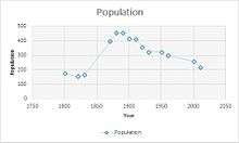
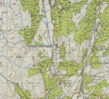
Satterthwaite is a small village (and civil parish) with around 50 dwellings situated in Grizedale, a valley in the Lake District, England, about four miles south of Hawkshead. It has a church, All Saints', and a Parish Room. The civil parish of Satterthwaite has its own community website. It had a population of 215 according to the 2011 census, In 2001 it had a population of 257 showing a decline in the population.[1] The difference between the population rates from the earlier year, for example 1881 to modern day statistics. These statistics show how the area of Satterthwaite has changed through generations.In 1881 the population was at its highest at 450, then started to gradually decline. The first sudden decline in population 1891 which was a long 10-year gap. The population fell to 410, this could show how Satterthwaite as an area is changing. The next sudden decline was in 1911, this has been the highest decline in population to happen in the history of Satterwaite. The population was 410 in 1911 whereas the population fell to 325 in 1931, which is a dramatic change for the area and may of effected trades and work for the people living there. Overall the population has declined from the early stages of Satterthwaite history, this is probably due to rural urban migration.[2]
In the 1870s Satterthwaite was described as "Satterthwaite, a village and a township-chapelry in Hawkshead parish, Lancashire. The village stands on the river Leven, 4 miles S E of Coniston r. station."[3]
Housing
Satterthwaite contains a mixture of houses, in 2011 a total of 152 were in the vicinity. The change between 2011 and 2001 is dramatically different in 2001 there was 166 houses.[4] This change suggests houses may have been converted or changed into a different establishment. In 2011, 104 of the 152 houses have at least one usual resident occupying the property. Comparison to 2001 is slightly different 166 dwellings and 112 out of 166[5] has residents living in them.[6] This leaves 48 houses with no usual resident, the house could be used as a second home. Detached housing is the majority type of house contributing 68 of the 152, This may mean that there is a vast amount of land surrounding these houses as well as Satterthwaite. Other type of houses are as follows; semi-detached 57, terraced 16 and flats being 10. These houses occupy varies age groups. A total of 34 of these houses have 1 occupant living in them.[7] Housing during the earlier years was very different to the housing of today in Satterthwaite. The difference was probably due to economy and capital flow that people had, as building a house required materials and expenses. With this though, in 1881 there was 82 houses in total. This obviously being a very different statistic than the numbers in the 2001 and 2011 census. In 10 years, 1891 only 10 new houses were built, this may have been an influx in population or that they had more land to build houses on. Again, the next 10 years 1901 only 2 houses were built. Then in 1921 there was a decline in houses, the previous 10 years was 94 but now it is 86. Satterthwaite as a place then starts to rebuild and create more houses for new people arriving into urban rural transition. The number of houses starts to rise and in 1961 the total number of houses is 102. This shows that people are moving towards the countryside and more into rural areas.[8]
Occupation

In Satterthwaite residents aged 16–74 that are in employment measure 137 in the year 2011, the majority of residents are employed, 29 residents were managers, directors and senior officials. The second highest job occupation is associate Professional and technical. These jobs seem to be highly qualified. 20 employees work on in the skilled trade section, incorporating their skills to work on houses throughout Satterthwaite. Another main occupation is caring, leisure and other service; 12 employees.Elementary occupations, qualified teachers count towards 18 occupation. Overall Satterthwaite has a range of occupations but they seem to require higher qualification jobs as for other districts. This should show how educated an area like Satterthwaite is.[9] 2001 is consistently differently to 2011, all people aged 16–74 in employment totals 145 slightly more, this may be due to population decreasing since the last Census. Managers and senior officials count at 24.[10] This is not the highest employment sector though, the main occupation is working in elementary valuing 27. Comparing this data to the occupational statistics in 1881 show a completely different aspect to life in Satterthwaite and shows the changes in industry as well as. This is probably due to improvements in technology as more advancing technology means people can become better and acquire different skills for more complex jobs. Education is also an advantage that people have in Satterthwaite at this current time compared to the occupational statistics in 1881. The main employment sector in 1881, for men, was agriculture. As Satterthwaite is a rural area and this was a large employment sector, agriculture is of high demand. Men usually do manual labour whereas women in that specific generations are more occupied in domestic jobs. This also shows as the main occupation for women in 1881 was domestic services or offices, the number of employed being 32. Yet again a large number of men work in the agriculture side of work, 39 males work in varies vegetable substances. These figures may have been more as it was difficult to find occupations in 1881.[11]
Ethnicity
The ethnic group in Satterthwaite is mainly white British, 213 of the 215 residents. With only 1 mixed ethnicity and 1 Asian. This shows that Satterthwaite does not have a diverse ethnic society. In the 2011 Census 83.5% of the residents of England were born in England, 208 out of 215. With such a high percentage of English the religion that is the most popular is Christianity, 135 out of 215. 52 residents are non-religious.[12] As Satterthwaite is mainly white British the main language they speak is obviously English (English or Welsh) 209 residents. All usual residents aged 3 and over equal 211. The two other residents equals European language.[13] Residents arriving in the Uk is another ethnic statistic that is relevant for Satterthwaite. In 2011, 208 of 215 residents were born in the United Kingdom. 4 residents arriving between 2004–2006.[14]
Health and Care
Satterthwaite has a higher average of very good health compared to the whole of England. Satterthwaite has a 49.8% very good health rating whereas England has a percentage of 47.2%. The percentage of residents that have good health is also a high percentage, 32.6%. The only poor percentage rating is the 3.7% of which have bad health, even though this is a small value it may affect some residents.[15] These percentages are relatively good but it is more realistic looking at genuine figures. In 2001 of all the 257 residents 187 of them have good health, it then declines rapidly. 53 have fairly good health and 17 have not good health. These figures are relatively good compared to England.[16] In 2011 these figures change. The population being 215 and 107 of them having very good health and 70 of them have good health. In 10 years the health and well being of Satterthwaite has become better, probably due to technology advances.[17] Disability may affect an area like Satterthwaite but due to the fact the population is not as high as other areas the disability rate will not be as high. In 2011 the population was 215 and out of them only 9 had day to day impacts due to their disability or could not do activities as best as possible. People affected in a little was equalled 27 people out of 215, this figure small yet again. Finally, 179 people are not affected by any sort of disability in Satterthwaite.[18]
Places to Visit
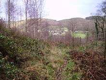
Satterthwaite has some beautiful surrounding areas and places to visit. Some of the main places to visit are Dale park, Grizedale forest and Graythwaite. Dale park is ideal for leisure activities such as hiking and rambling, looking at the landscape throughout the high, middle and low altitudes.[19] Grizedale is also ideal for leisure activities as the area of the land is 24.47km2 A campsite is the main attraction swell as cycling and walking paths. Within Grizedale is the Force Forge and Force Mills. The water from Force Beck exit out the Force Mill as well as Force Forge.[20] Graythwaite is situated at the Southern Eastern corner of Satterthwaite. The hall is closed to the public but the Graythwaite hall garden are open for tourists.[21]
Land Use
The total area of all and types in Satterthwaite in square metres is 29,329.36. The area of domestic buildings incorporating in all the ground space equals 21.31 this leaves 14.65 square metres being non-domestic building use. The large majority of land in Satterthwaite is greenery but the area of road accumulates to 452.82, large public footpaths are also throughout Satterthwaite and contributing to 3.86 square metres.[22]
References
- ↑ "Satterthwaite: Key Figures for 2011 Census: Key statistics". Neighbourhood statisistcs. Office for National Statistics. Retrieved 27 January 2015.
- ↑ "Total Population". Vision of Britain. Retrieved 26 April 2015.
- ↑ Wilson, John Marius (1870). Gazetteer of England and Wales. Edinburgh: A.Fullerton & Co. Retrieved 27 January 2015.
- ↑ "Housing stock,2001". Neighbourhood statistics. Retrieved 24 March 2015.
- ↑ "Parish Profile- Accommodation and Tenure,2001". Neighbourhood statistics. Retrieved 24 March 2015.
- ↑ "Household Spaces (2011)". Neighbourhood statistics. Retrieved 16 March 2015.
- ↑ "Area Information for Satterthwaite, Ulverston, LA12 8LR". Retrieved 9 March 2015.
- ↑ "Housing". Vision of Britain. Retrieved 26 April 2015.
- ↑ "Occupation (Minor groups)". Neighbour Statistics (2011). Retrieved 16 March 2015.
- ↑ "Occupation Groups- All People, 2001". Neighbourhood Statistics. Retrieved 24 March 2015.
- ↑ "Administrative unit, Satterthwaite". Vision of Britain. Retrieved 26 April 2015.
- ↑ "Area Information for Satterthwaite, Ulverston, LA12 8LR". Retrieved 9 March 2015.
- ↑ "Main Language, 2011". Neighbourhood Statitstics. Retrieved 24 March 2015.
- ↑ "Year of Arrival in the UK, 2001". Neighbourhood Statistics. Retrieved 24 March 2015.
- ↑ "Health and Care". Neighbourhood Statistics. Retrieved 24 March 2015.
- ↑ "General Health, 2001". Neighbourhood Statistics. Retrieved 24 March 2015.
- ↑ "General Health, 2011". Neighbourhood Statistics. Retrieved 24 March 2015.
- ↑ "Long term health problems or disability, 2011". Neighbourhood Statistics. Retrieved 26 April 2015.
- ↑ "Satterhwaite Parish Community website". Retrieved 9 March 2015.
- ↑ "Satterhwaite Parish Community website". Retrieved 9 March 2015.
- ↑ "Satterhwaite Parish Community website". Retrieved 9 March 2015.
- ↑ "Land Use Statistics". Neighbourhood Statistics. Retrieved 24 March 2015.
External links
![]() Media related to Satterthwaite at Wikimedia Commons
Media related to Satterthwaite at Wikimedia Commons