Sataoa
| Sataoa | |
|---|---|
| Village | |
 Sataoa | |
| Coordinates: 13°59′S 171°50′W / 13.983°S 171.833°W | |
| Country |
|
| District | Tuamasaga |
| Time zone | -11 |
Sataoa is a small village situated on the central south coast of Upolu island in Samoa. Like many villages in the country, Sataoa has two settlements, one inland (Sataoa Uta) and one by the coast (Sataoa Tai). The population of Sataoa Uta is 924 (2006 Census) and Sataoa Tai is 320 (2006 Census).[1]
Satoa is part of Safata Electoral Constituency (Faipule District) which forms part of the larger political district of Tuamasaga.[2]
References
- ↑ "Population and Housing Census Report 2006" (PDF). Samoa Bureau of Statistics. July 2008. Retrieved 19 December 2009.
- ↑ "Samoa Territorial Constituencies Act 1963". Pacific Islands Legal Information Institute. Retrieved 19 December 2009.
Coordinates: 13°59′S 171°50′W / 13.983°S 171.833°W
| Villages | 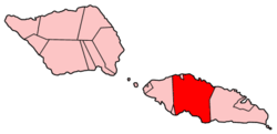 | |
|---|---|---|
| Notable landmarks |
| |
| Archaeology in Samoa |
| |
| Education & Libraries |
| |
| Environment | ||
| Electoral constituencies: Faipule Districts |
| |
This article is issued from Wikipedia - version of the 11/27/2015. The text is available under the Creative Commons Attribution/Share Alike but additional terms may apply for the media files.