Sasaram
| Sasaram सासाराम | |
|---|---|
| City | |
|
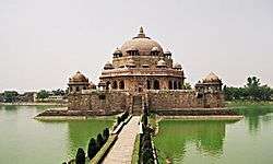
A view of the Tomb of Sher Shah Suri | |
 Sasaram Location in Bihar, India | |
| Coordinates: 24°57′N 84°02′E / 24.95°N 84.03°ECoordinates: 24°57′N 84°02′E / 24.95°N 84.03°E | |
| Country |
|
| State | Bihar |
| Region | Shahabad |
| Division | Patna Division |
| District | Rohtas |
| Ward | 40 |
| Government | |
| • Type | Municipal Council |
| • Body | Sasaram Municipality |
| • Chairman | Nazma Begum |
| Elevation | 110 m (360 ft) |
| Population (2014)[1] | |
| • Total | 147,408 |
| • Rank | 180th |
| Demonym(s) | Sasaramite |
| Time zone | IST (UTC+5:30) |
| PIN | 821115 |
| Telephone code | 91-6184 |
| Vehicle registration | BR 24 |
| Railway Station | Sasaram Junction railway station |
| Website |
rohtas |
Sasaram (Hindi: सासाराम, Urdu: سسرام), sometimes also spelled as Sahsaram, is the administrative headquarter of the Rohtas district in the Indian state of Bihar. Rohtas, an historical place, became a District, carved out of the district of Shahabad, in the year 1972.
It is famous for production of stone chips, and for quarrying industry. Major languages spoken in this region are Bhojpuri, Hindi, and Urdu; local religions include Hinduism, Islam, Sikhism, Buddhism, and Jainism.
History
Sasaram is the birthplace of the Afghan king Sher Shah Suri, who ruled over Delhi, much of northern India, what is now Pakistan, and eastern Afghanistan for five years, after defeating the Mughal Emperor Humayun. Many of Sher Shah Suri's governmental practices were adopted by the Mughals and the British Raj including taxation, administration, and the building of a paved road from Kabul to Bengal.
Sher Shah Suri's 122 feet (37 m) red sandstone tomb, built in the Indo-Afghan style stands in the middle of an artificial lake at Sasaram. It borrows heavily from the Lodhi style, and was once covered in blue and yellow glazed tiles indicating an Iranian influence. The massive free standing dome also has an aesthetic aspect of the Buddhist stupa style of the Mauryan period. The tomb of Sher Shah's father Hasan Khan Suri is also at Sasaram, and stands in the middle of green field at Sherganj, which is known as Sukha Rauza. About a kilometer to the North West of Sher Shah's tomb lies the incomplete and dilapidated tomb of his son and successor, Islam Shah Suri.[2] Sasaram also has a baulia, a pool used by the emperor's consorts for bathing.

The fort of Sher Shah Suri at Rohtasgarh is in Sasaram. This fort has a history dating back to the 7th century AD. It was built by Raja Harishchandra in the name of his son Rohitashwa, son of illustrious king Harishchandra, known for his truthfulness. It houses the Churasan temple, Ganesh temple, diwan-e khas, diwan-e-aam, and various other structures dating back to different centuries. The fort also served as the headquarters of Raja Man Singh during his reign as the governor of Bihar and Bengal under the regime of Akbar. The Rohtaas fort in Bihar should not be confused with another fort of the same name, near Jhelum, Punjab, in what is now Pakistan. The Rohtaas fort in Sasaram was also built by Sher Shah Suri, during the period when Humayun was exiled from Hindustan.
There is a temple of Goddess Tarachandi, two miles to the south, and an inscription of Pratap Dhawal on the rock close to the temple of Chandi Devi. Hindus in large number assemble to worship the goddess. Dhuwan Kund, located about 36 km. South-West of this town, is one of the attractive tourist places and it can be developed as a beautiful natural site. Gupta Dham is also an attractive tourist and religious place, situated in the Chenari Block of this district. This also can be developed as beautiful natural site. This place is a famous centre of Shiva-Aradhana. Hindus in large numbers assemble here to worship the Lord Shiva. The two waterfalls have enough capacity to generate 50-100 MW of electricity, if utilized properly.
There are several monuments near Sasaram, the headquarter of Rohtas district, inclusing Akbarpur, Deomarkandey, Rohtas Garh, Shergarh, TaraChandi, Dhuwan Kund, Gupta Dham, Bhaluni Dham, Historical Gurudwara and Tombs of Chandan Shaheed, Hasan Khan Sur, Sher Shah, Salim Sah and Alawal Khan.
Rohtas, south of Sasaram, is known to have been the residence of one Satyawadi Raja Harischandra, named for his son, Rohitashwa. Sasaram is also famous for the Samrat Ashok pillar (one of the thirteen laghu shilalekh), situated in a small cave of Kaimur hill, near Chandan Shaheed.
Samadhi of Shree Shree 1008 Shree Swami Parmeshwara Nand Ji Maharaj, also known as Adwait Ashram, Dakshin Kutia, Situated in Parampuri (Raipur Chaur) 12 kilometres (7.5 mi) from Sasaram. It (Adwait Ashram) has nearabout 24 branches over Country in many states. The headquarters is in Sasaram, and is also known as Navlakha Ashram.
Babu Nishan Singh who was the general of Babu Kunwar Singh's army fighting against the British during the 1857 GADAR freedom struggle, came from Sasaram. Jainath Bhawan is a grand mansion built by a magistrate named Babu Harihar Prasad Verma, and his wife Uma Devi Verma, in 1945. The mansion is named for Babu Jainath Prasad, who was a Zamindar and the first lawyer to practice in English. A secondary school founded by Uma Devi Verma, named Harihar Uma Madhyamik Vidyalaya, still runs at the Meyari Bazar, although it is now administered by the government.
Tomb of Sher Shah Suri
Coordinates: 24°56′N 84°01′E / 24.933°N 84.017°E
This site is included in UNESCO World Heritage Centre - Tentative list.[3]
Tomb of Sher Shah, built in the middle of the town, is one of the noblest specimens of Pathan architecture in India, is an imposing structure of stone, standing in the middle of a fine tank, and was built towards the middle of sixteenth century. Its height from the floor to the apex of the dome is 101 feet and its total height above the water is over 150 feet. The octagon forming the tomb has an interior diameter of 75 feet and an exterior diameter of 104 feet. The tomb is the second highest in India which attracts tourists. The tomb of Shershah Suri at Sasaram is an imposing structure of stone standing in the middle of a fine tank and rising from a large stone terrace. This terrace rests obliquely on a platform with a flight of steps leading to the water's edge. The upper terrace is enclosed by a battlemented parapet wall with octagonal domed chambers at four corners, two small projecting pillared balconies on each of its four sides and pierced with a doorway in the east forms the only approach to the tomb. In the middle of the upper terrace stands the building of the mausoleum on a low octagonal plinth. The building consists of a very large octagonal chamber surrounded by a wide verandah on al the four sides. Internally, the verandah is covered by a series of 24 small domes, each supported on four arches but as the roof is a pillared cupola adorned by panels of white glazed tiles now much discoloured. The tomb chamber has three lofty arches on each of the eight sides. They rise 22 feet higher than the verandah roof and support the magnificent and lofty dome which is one of the largest domes in India. Surrounding the main dome are eight pillared cupolas on the corners of the octagon of the chamber walls. The interior of the tomb is sufficiently well ventilated and lighted through large windows on the top portion of the walls fitted with stone jalis in varying patterns. The jambs and spandrils of the arch of the mihrab on the western wall were once profusely adorned with verses from the Quran and inscriptions, with glazed tiles of various colours arranged in geometrical patterns and with beautiful floral carvings in stone enclosed in enamel borders. Much of this decoration has vanished already. Traces of similar decoration in enamel or glazed tile works are also to be scen on the interior of the dome, the walls and the cupolas on the outside. In a small arched recess above the mihrab on the outside wall is an inscription in two lines recording the completion of the tomb by his son and successor Salim or Islam Shah, some 3 months after the death of Sher Shah who died in A.H. 952 (A.D.1545). It is second largest dome of India. The tomb of Hasan Khan Sur, father of Sher Shah is also located in the town. This tomb is also known as Sukha Roza.
Geography
Sasaram is located at 24°57′N 84°02′E / 24.95°N 84.03°E.[4] It has an average elevation of 200 metres (660 ft).
Climate
As sasaram is surrounded by hills from two sides and so the climate of Sasaram is seasonable (means in winter it is too cold and in summer it is too hot). Climate is characterized by relatively high temperatures and evenly distributed precipitation throughout the year. The Köppen Climate Classification sub-type for this climate is "Cfa" (Humid Subtropical Climate).[5]
| Climate data for sasaram, India | |||||||||||||
|---|---|---|---|---|---|---|---|---|---|---|---|---|---|
| Month | Jan | Feb | Mar | Apr | May | Jun | Jul | Aug | Sep | Oct | Nov | Dec | Year |
| Average precipitation mm (inches) | 19.2 (0.756) |
21.2 (0.835) |
14.3 (0.563) |
7.6 (0.299) |
12.2 (0.48) |
120.9 (4.76) |
297.5 (11.713) |
326.2 (12.843) |
181.5 (7.146) |
50.9 (2.004) |
10.2 (0.402) |
3.6 (0.142) |
1,065.3 (41.943) |
| Source: Weatherbase[6] | |||||||||||||
it is one of the most hottest city in bihar after gaya and patna.
Connectivity and transportation
Sasaram is well connected both by road and railway. The NH2 (Grand Trunk Road) passes through the city. The main mode of local transportation are buses operated by both private operators and the state government. The private buses are more frequent and connected to most of the local bazaars. NH2 connects Delhi in North-West via Varanasi, Mirzapur, Allahabad, Kanpur and Kolkata in East via Gaya, Dhanbad. Various state highways also connect Sasaram with Patna, the capital of Bihar (via Bikramganj, Piro, Ara), Buxar (on the bank of holy river Ganga via Kargahar, Kochas, Rajpur).
Sasaram railway station
Sasaram has a Junction railway station which is located in the centre of the city on the Grand Trunk Road. The railway route through Sasaram is the Grand Chord line of Indian Railways, connecting Kolkata and New Delhi, and has three railway tracks running in parallel. Another railway line connects Sasaram Junction to Patna Junction via Ara. Sasaram station is about 100 kilometres (62 mi), or two and a half hours journey from Varanasi, and a similar distance from BodhGaya, the most sacred place in Buddhism. Trains run from Sasaram to Kolkata, New Delhi, and Bombay. The trains which stop in Sasaram include the Kalka Mail, Purushottam Exp, Mahabodhi Exp, Ranchi Garib Rath, Kolkata Mail, Jodhpur Exp, Chambal Exp, Shipra Exp, Chennai Egmore Exp, Nandan Kanan Exp, Neelanchal Exp and Poorva Exp. Also a weekly AC train has been started from Sasaram to Anand vihar(New Delhi) in July 2011 {22409/22410- Sasaram - ANVT AC Express}. However, this AC train has been converted into Garib Rath and runs between Gaya and Anand Vihar terminal.
Time Table
- Indian Trains: http://www.indiantrains.org/station-details/?code=SSM&name=SASARAM[7]
- http://rohtas.bih.nic.in/si_railtime.html[8]
Education
Bihar has among the lowest rates of literacy in India, but Sasaram doesn't share this trend and it is the second most literate city. Due to the lack of sources of employment, students of higher education often choose to migrate to other cities in search of employment. There are four government colleges, but no university, and most of the students prefer to go to more developed cities, such as Bangalore, New Delhi, Pune, Patna and Varanasi for higher education. There has been a new engineering college set up in region.However, there has been increase in literacy rate under the governance of Nitish Kumar, Chief Minister of Bihar; and Sasaram is the second most literate city in Bihar, which in turn has made Rohtas the most literate district in Bihar.
Medical colleges
- Narayan Medical College and Hospital[9]
- Mahatma Phule Medical College and Hospital in baradih Muradabad, sasaram.
Engineering College
- College of Engineering and Management Rohtas
- Shershah College of Engineering
Law College
- Rohtas Law College[10]
Government Colleges (Science/Arts/Commerce)
- Sri Shankar College
- Shanti Prasad Jain College
- Sher shah Suri College
- Rohtas Mahila MahaVidyalaya
Private Colleges
- Audhut Bhagwan Ram Mhavidayalaya
- Sst college
Inter Colleges and High Schools
- MP Inter College, Sasaram (Earlier known as Town High School and MP High School)
- High School Chaukhandi Path, Sasaram
- St. Paul School, Civil line, Sasaram
- D.A.V. Public School
- Sri Shankar Rajkiya Inter College[11]
- Rama Rani Jain High School (for girls)
- Rajendra vidayalaya (Mahavir Asthan)
- Bal Bharti public school (Civil Lines)
Notable persons
- Babu Jagjivan Ram: Deputy Prime Minister of India (From March 24, 1977 to July 28, 1979),[12][13]
- Mira Kumar: Speaker of the Lok Sabha (2009 to 2014),[14][15]
- Chhedi Paswan: Bharatiya Janata Party leader, Member of the India Parliament
- Pilot Baba: Indian spiritual guru
IT and e-governance

SAHAJ Vasudha Kendra, the first Common Service Centre, or eKiosk, in Rohtas District was inaugurated in Jamuhar village on 15 August 2008. The centre is currently planning to start a Block information Centre, e-district plan, and SAWAN SASARAM.
Demographics
As of 2011 India census, Sasaram had a population of 147,408. Males constitute 52% of the population and females 48%. Sasaram has an average literacy rate of 80.26%, higher than the national average of 74%; male literacy is 85%, and female literacy is 75%. In Sasaram, 13% of the population is under 6 years of age.[16] Sasaram is 16th most populous city in bihar.
Economy
The closure of the industries of the Dalmia group, at Dalmianagar resulted in widespread unemployment. Sasaram's economy is mainly driven by agriculture and related industries like rice polishing. Canal irrigation system is also very prominent in this area. Because of the fertile land around the town it is a local trading center for food grains, agricultural products, and agricultural equipment. The region is also known as Dhan Ka Katora, meaning "a bowl of food grains". The rice grown near Sasaram is sold in the markets of Kolkata and New Delhi. The only significant industry is rock quarrying.
Lok Sabha Constituency
Sasaram (Lok Sabha constituency) is one of the 40 Lok Sabha (parliamentary) constituencies in Bihar state in eastern India. The following is the list of the Members of Parliament elected from this Lok Sabha constituency:[17]
- 1952: Jagjivan Ram, Indian National Congress
- 1957: Jagjivan Ram, Indian National Congress
- 1962: Jagjivan Ram, Indian National Congress
- 1967: Jagjivan Ram, Indian National Congress
- 1971: Jagjivan Ram, Indian National Congress
- 1977: Jagjivan Ram, Janata Party
- 1980: Jagjivan Ram, Indian National Congress (Jagjivan)
- 1984: Jagjivan Ram, Indian National Congress (Jagjivan)
- 1989: Chhedi Paswan, Janata Dal
- 1991: Chhedi Paswan, Janata Dal
- 1996: Muni Lall, Bharatiya Janata Party
- 1998: Muni Lall, Bharatiya Janata Party
- 1999: Muni Lall, Bharatiya Janata Party
- 2004: Meira Kumar, Indian National Congress
- 2009: Meira Kumar, Indian National Congress
- 2014* Chhedi Paswan Bharatiya Janata Party
References
- ↑ "Census of India Search details". censusindia.gov.in. Retrieved 10 May 2015.
- ↑ Sanatani, Rohit Priyadarshi. "The Tomb of Salim Shah Suri (Islam Shah): The glory that never was.". The Speaking Arch. Retrieved 27 March 2015.
- ↑ (http://whc.unesco.org/en/tentativelists/1093/)
- ↑ Falling Rain Genomics, Inc - Sasaram
- ↑ Climate Summary for sasaram, India
- ↑ "Weatherbase.com". Weatherbase. 2013. Retrieved on July 31, 2013.
- ↑ http://www.indiantrains.org/station-details/?code=SSM&name=SASARAM
- ↑ http://rohtas.bih.nic.in/si_railtime.html
- ↑ http://narayanmedicalcollege.org
- ↑ http://www.indiastudychannel.com/colleges/25697-Rohtas-Law-College.aspx
- ↑ http://jagdishpur.blogspot.in/2012/02/veer-kunwar-singh-university-vksu.html
- ↑ Jagjivan Ram
- ↑ Deputy Prime Minister of India
- ↑ Meira Kumar
- ↑ Speaker of the Lok Sabha
- ↑ http://www.census2011.co.in/census/city/178-sasaram.html
- ↑ Sasaram (Lok Sabha constituency)
External links
| Wikimedia Commons has media related to Sasaram. |
-
 Sasaram travel guide from Wikivoyage