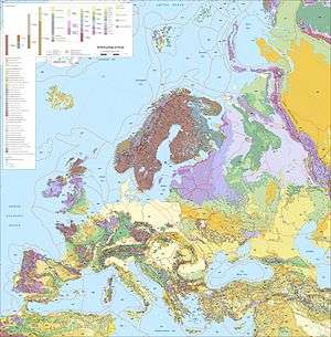
Sarmatian Craton
The Sarmatian Craton is a geological and tectonics term for the southern segment/region of the East European Craton also known as Scythian Plateau. The craton contains Archaean rocks 2.8 to 3.7 billion years old. During the Carboniferous Period the craton was rifted apart by the Dneiper-Donets rift. As a result, geomorphologically the cratonic area is split by the Donbass Fold Belt, also known as a part of the large Pripyat-Dniepr-Donets aulacogen, which transects Sarmatia, dividing it into the Ukrainian Massif or shield on the southwest and the Voronezh Massif to the northeast.
Sarmatia is made up of several once-independent Archaean land masses that formed respectively at 3.7—2.9, 3.6—2.8, 3.2—3.0, and 2.7—2.6 Ga. These are separated by a series of 2.2—2.1 Ga orogenic belts. Sarmatia's northwestern margin has an extensive continental magmatic arc dating back to 2.0—1.95 Ga.[1]
References
- ↑ Bogdanova S.B., Bingen B., Gorbatschev R., Kheraskova T.N., Kozlov V.I., Puchkov V.N. & Volozh Yu.A. (2008). "The East European Craton (Baltica) before and during the assembly of Rodinia" (PDF). Precambrian Research. 160 (1—2): 23–45. doi:10.1016/j.precamres.2007.04.024.
- Bogdanova, Svetlana V. (2005) "The East European Craton: Some Aspects of the Proterozoic Evolution in its South-West." Polskie Towarzystwo Mineralogiczne - Prace Specjalne Mineralogical Society of Poland – Special Papers, Zeszyt 26, 2005; Vol. 26. Online: http://www.geo.uw.edu.pl/PTMINSP/2005/018.pdf
- Svetlana Bogdanova (Lund) and EUROBRIDGE, Palaeoproterozoic Accretion of Sarmatia and Fennoscandia
- Dmitry A. Ruban and Shoichi Yoshioka, Late Paleozoic - Early Mesozoic Tectonic Activity within the Donbass (Russian Platform)