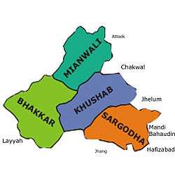
Sargodha
| Sargodha سرگودھا | ||||||
|---|---|---|---|---|---|---|
| City District / Divisional Capital | ||||||
| ||||||
 Sargodha | ||||||
| Coordinates: 32°5′1″N 72°40′16″E / 32.08361°N 72.67111°ECoordinates: 32°5′1″N 72°40′16″E / 32.08361°N 72.67111°E | ||||||
| Country | Pakistan | |||||
| Province | Punjab | |||||
| Division[1] | Sargodha Division | |||||
| Government | ||||||
| • Commissioner | Captain Muhammad Asif | |||||
| Area | ||||||
| • Total | 5,854 km2 (2,260 sq mi) | |||||
| Population (2015)[2] | ||||||
| • Total | 1,500,000 | |||||
| • Rank | 11th (Pakistan)[3] | |||||
| • Density | 260/km2 (660/sq mi) | |||||
| Time zone | PST (UTC+5) | |||||
| Postal code | 40100[4] | |||||
| Dialling code | 048[5] | |||||
| Number of towns | 59 | |||||
| Number of union councils | 22 | |||||
| Website | http://www.sargodha.gop.pk/; http://cbs.gov.pk/; http://www.tmasargodha.com/ | |||||


Sargodha (Punjabi, Urdu: سرگودھا) is a city and the administrative centre of the Sargodha Division located in the Punjab province, Pakistan. It is the 11th largest city in Pakistan[3] and one of the fastest growing cities in Pakistan.[6]
History
The origins of this city are quite old but the proper town was established by the British in 1903.[7] Although it was a small town in the beginning, the British Royal Air Force built an airport here due to its strategic location.[8]
Geography
Sargodha is located 172 kilometres northwest of Lahore, in Sargodha District. It lies about 30 miles from the M-2 motorway, which connects Lahore and Islamabad. It is connected to the M-2 by several interchanges at different locations. Sargodha is roughly 94 km from Faisalabad, due southeast. Directly east connected by the M-2 motorway are Lahore and the route to Rawalpindi and Islamabad. Due east is the city of Jhang; toward the west are the city of Mianwali and the Chashma Barrage. Dera Ismail Khan is located 232 km southwest from the city.
Sargodha mainly comprises flat, fertile plains, although here are a few small hills on the Sargodha-Faisalabad Road. The River Jhelum flows on the western and northern sides, and the River Chenab lies on the eastern side of the city. [9]
Climate
The city has a climate of extreme heat in the summers and moderate cold in the winters. The maximum temperature reaches 50 °C (122 °F) in the summer while the minimum temperature recorded is as low as freezing point in the winter.
| Climate data for Sargodha (1960–2012) | |||||||||||||
|---|---|---|---|---|---|---|---|---|---|---|---|---|---|
| Month | Jan | Feb | Mar | Apr | May | Jun | Jul | Aug | Sep | Oct | Nov | Dec | Year |
| Average high °C (°F) | 20 (68) |
22 (72) |
26 (79) |
32 (90) |
38 (100) |
39 (102) |
38 (100) |
37 (99) |
36 (97) |
32 (90) |
26 (79) |
22 (72) |
30.6 (87.1) |
| Average low °C (°F) | 8 (46) |
11 (52) |
15.5 (59.9) |
19 (66) |
25 (77) |
27 (81) |
26 (79) |
26 (79) |
25 (77) |
20 (68) |
14 (57) |
9 (48) |
18.8 (65.8) |
| Average precipitation mm (inches) | 18 (0.71) |
36 (1.42) |
24 (0.94) |
13 (0.51) |
17 (0.67) |
48 (1.89) |
82 (3.23) |
87 (3.43) |
43 (1.69) |
9 (0.35) |
11 (0.43) |
12 (0.47) |
400 (15.74) |
| Average precipitation days (≥ 1.0 mm) | 5 | 4 | 5 | 4 | 3 | 3 | 7 | 7 | 4 | 1 | 1 | 1 | 45 |
| Source: Weather2,[10] | |||||||||||||
Demographics
Total population of the city was 458,440[3] according to the 1998 census. The majority of the people in the city speak Punjabi.[8]
Administration
Sargodha is the capital of Sargodha Tehsil. As of October 2012, the division system in Punjab Province has been restored and Sargodha became the divisional headquarters of districts Sargodha, Khushab, Mianwali and Bhakkar. The city of Sargodha is administratively subdivided into 22 union councils.[11]
Local features
Sargodha lies about 30 miles (48 km) from the M-2 motorway which connects Lahore and Islamabad. It is also connected to Faisalabad by a highway. Daewoo Bus Service drives regular routes from Sargodha to the rest of the country.[12] Sargodha is also connected by the rest of the country through the rail.[13] Sargodha Junction railway station is located on Shorkot-Lala Musa branch railway line. Sargodha is home to the Sargodha Cricket Stadium.[14]
Mushaf Air Base
Pakistan's largest airbase, PAF Base Mushaf (formerly PAF Base Sargodha), is situated in Sargodha and hosts the headquarters of the Pakistan Air Force's Central Air Command. The airbase is also home to the Combat Commanders School (CCS), formerly the Fighter Leader's School.[15]
Educational institutions
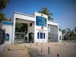
- University of Sargodha
- Sargodha Medical College
- Quaid-e-Azam Law College
- Greenfield College Sargodha
- Airbase Inter College
- Sargodha Institute of Technology
- PAF Public School, Sargodha
Notable people
- Feroz Khan Noon, former Prime Minister Pakistan
- Anwer Ali Noon, former Parliamentarian of Pakistan and army Officer
- Amjad Ali Noon, former Ambassador/High Commissioner of Pakistan
- Imtiaz Bhatti, former Ambassador / High Commissioner of Pakistan
- Wazir Agha, Urdu Scholar
- Hameed Gul, former ISI Chief
- Ch. Anwar Ali Cheema, politician, PML-Q
- Ch.Ghias Mela, politician, PML-Q
- Hafiz Muhammad Saeed, Amir Jama'at-ud-Da'wah
- Mohammad Hafeez, cricketer
- Aizaz Cheema, cricketer
- Rafiq Anjum, actor
- Jahanzeb Qamar, television writer
References
- ↑ "Sargodha Division". getamap.net.
- ↑ http://www.urbanunit.gov.pk/PublicationDocs/Punjab%20city%20profiles/Sargodha%20City%20Profile.pdf
- 1 2 3 "Population size and growth of major cities" (PDF). Pakistan Bureau of Statistics. 1998.
- ↑ "Pakistan Post Office Department". Retrieved 12 March 2016.
- ↑ "National Dialing Codes". Retrieved 12 March 2016.
- ↑ "Commercial Real Estate Property in Sargodha Pakistan - Ghar47". Ghar47. Retrieved 12 March 2016.
- ↑ "TDCP (Tourism Development Corporation of Punjab) > Explore Pakistan > About Punjab > Major Cities > Sargodha". tdcp.gop.pk.
- 1 2 "District Website". lhc.gov.pk.
- ↑ "District at Glance". sargodha.gop.pk.
- ↑ "Weather2 – Sargodha". Retrieved 8 July 2012.
- ↑ "Tehsils & Unions in the District of Sargodha - Government of Pakistan". Nrb.gov.pk. Retrieved 2012-03-15.
- ↑ http://www.daewoo.com.pk/terminal_view.asp?menu_set=5&submenu_set=1&page_title=Sargodha&terminal_code=13
- ↑ "Pakistan Railway Time Table". railpk.com.
- ↑ "Sports Stadium - Pakistan - Cricket Grounds - ESPN Cricinfo". Cricinfo.
- ↑ "About Sargodha". glowpakistan.com.