Sarandë
| Sarandë | ||||||||||
|---|---|---|---|---|---|---|---|---|---|---|
| Municipality | ||||||||||
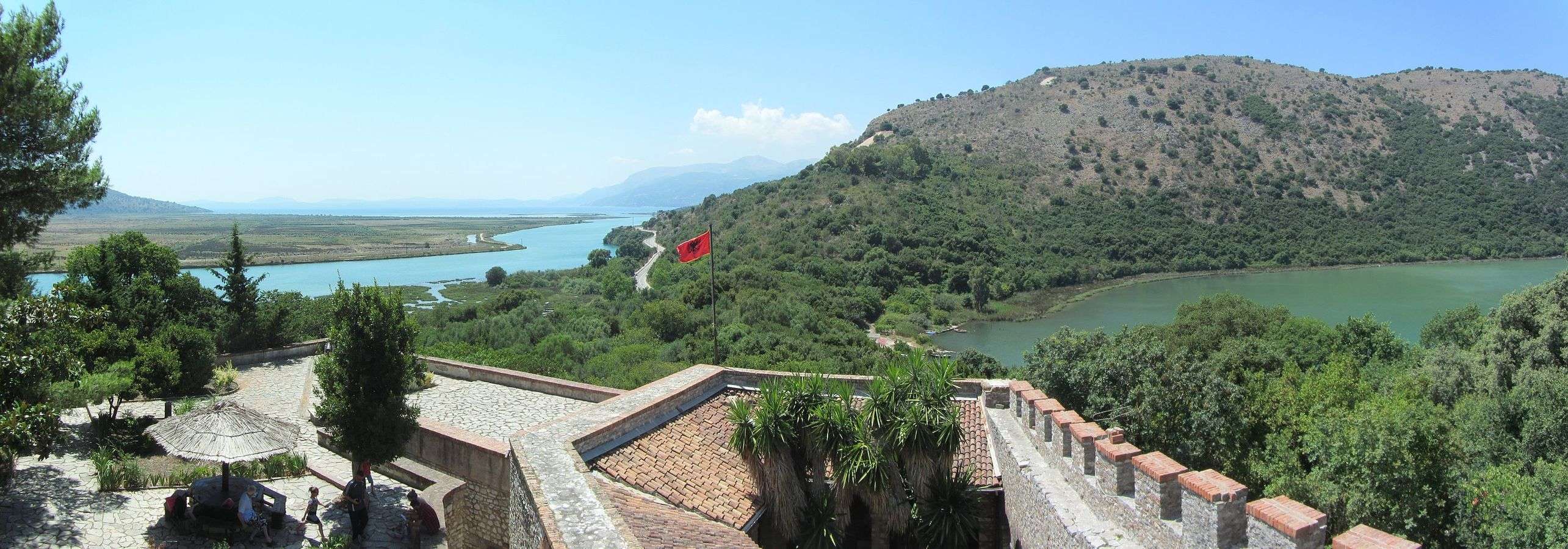
Clockwise from top: The Promenade of Saranda, Ancient City of Butrint, Lëkurësi Castle, Streets of Saranda, Blue Eye Spring, Coastline of Saranda, Harbour of Saranda and the Butrint National Park | ||||||||||
| ||||||||||
 Sarandë | ||||||||||
| Coordinates: 39°52.5′N 20°0.6′E / 39.8750°N 20.0100°ECoordinates: 39°52.5′N 20°0.6′E / 39.8750°N 20.0100°E | ||||||||||
| Country |
| |||||||||
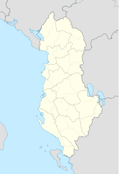
| County | Vlorë | |||||||||
| Government | ||||||||||
| • Mayor | Florjana Koka (SP) | |||||||||
| Area | ||||||||||
| • Municipality | 58.96 km2 (22.76 sq mi) | |||||||||
| Elevation | 0.8 m (2.6 ft) | |||||||||
| Population (2011) | ||||||||||
| • Municipality | 20,227 | |||||||||
| • Municipality density | 340/km2 (890/sq mi) | |||||||||
| • Administrative Unit | 17,233 | |||||||||
| Time zone | CET (UTC+1) | |||||||||
| • Summer (DST) | CEST (UTC+2) | |||||||||
| Postal Code | 9701–9703 | |||||||||
| Area Code | (0)85 | |||||||||
| Vehicle registration | AL | |||||||||
| Website | Bashkia Sarandë | |||||||||


Saranda or Sarandë (Greek: Άγιοι Σαράντα, Agioi Saranda, Italian: Santiquaranta) is a town and municipality in Vlorë County, southern Albania. It is one of the most important tourist attractions of the Albanian Riviera. It is situated on an open sea gulf of the Ionian Sea in the central Mediterranean, about 14 km (8.7 mi) east of the north end of the Greek island of Corfu.
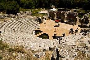
Near Sarandë are the remains of the ancient city of Butrint, a UNESCO World Heritage site. Sarandë has a Greek minority and is considered one of the two centers of the Greek community in Albania.[1]
History
Etymology
Saranda is from the name of the Byzantine monastery of the Agioi Saranda (Greek: Άγιοι Σαράντα), meaning the "Forty Saints" and honoring the Forty Martyrs of Sebaste. Under Turkish rule, this became Aya Sarandi and then Sarandoz. Owing to Venetian influence in the region, it often appeared under its Italian name Santi Quaranta on Western maps.[2] This usage continued even after the establishment of the Principality of Albania, owing to the first Italian occupation of the region. During the second occupation in World War II, Benito Mussolini changed the name to Porto Edda, in honor of his eldest daughter.[3][4] Following the restoration of Albanian independence, the city employed its Albanian name Saranda.[5]
Ancient
In antiquity the city was known by the ancient Greek name of Onchesmos or Anchiasmos[6][7][8] and was inhabited by the Greek tribe of the Chaonians.[9] Onchesmos flourished as the port of the Chaonian capital Phoenice[10][11] (modern-day Finiq).
The city was probably raided by the Ostrogoths in 551 AD,[12] while during this period it became also the target of piratic raids by Gothic ships.[13] In a medieval chronicle of 1191 the settlement appears to be abandoned, while its former medieval name (Anchiasmos) isn't mentioned any more. From that year, the toponym borrows the name of the nearby Orthodox basilica church of Agioi Saranta, erected in the 6th century, ca. 1 km (0.6 mi) southeast of the modern town.[12]
In 1878, a Greek rebellion broke out, with revolutionaries taking control of Sarandë and Delvinë. This was suppressed by the Ottoman troops, who burned twenty villages in the region.[14]
20th century
.jpg)
The town was included in the newly formed Albanian state in 1913 under the terms of the Protocol of Florence.[15] It was occupied twice by Greece in 1913 and from 1914 to 1916, the second time by Greek insurgents from the Autonomous Republic of Northern Epirus. In May 1914, negotiations were started in Sarande between representative of the provisional government of Northern Epirus and that of Albania which continued in nearby Corfu and ended up with the recognition of the Northern Epirote autonomy inside the newly established Albanian state.[16]
It was then occupied by Italy between 1916 and 1920 as part of the Italian Protectorate on southern Albania.[17] Sarandë was again occupied by Italian forces in 1939 and was a strategic port during the Italian invasion of Greece. During this occupation, it was called "Porto Edda" in honor of the eldest daughter of Benito Mussolini.
During the Greco-Italian War, the city came under the control of the advancing Greek forces, on 6 December 1940. The capture of this strategic port further accelerated the Greek penetration to the north.[18] As a result of the German invasion in Greece in April 1941, the town returned to Italian control. On 9 October 1944 the town was captured by a group of British commandos under Brigadier Tom Churchill and local partisans of LANÇ under Islam Radovicka. The involvement of the British troops was considered problematic by LANÇ as they considered that they would use the town as their base and install their allies from Greece in the area as British documents indicate that EDES forces also joined the operation. However, the British troops soon withdrew from the region, leaving the region to the Albanian communist forces.[19]
Geography
The present municipality was formed at the 2015 local government reform by the merger of the former municipalities Ksamil and Sarandë, that became municipal units. The seat of the municipality is the town Sarandë.[20]
Topography
The district of Saranda lies in the most southern extremity of Albania. It is bordered with Vlora to the north, Delvina and Gjirokastër to the east and with Greece to the south of Ionian Sea. Saranda is a place in the most southern part of Albania. It lies between the hills that descend and reach the Ionian Sea. The district of Saranda has a plain relief which is composed of southern seashore mountains that lie from Borsh to the bay of Ftelia, Vrina Fields and the hills of Saranda, Lëkurësi, Ksamil, Butrint and Konispol. All these units make up the southern part of the Albanian Riviera where the eye catches the countless bays, beaches, the rocky coastline, hills with olives and citrus, mountains that surround the landscape. Saranda is traversed by Kalasa, Bistrica and Pavlla rivers which flow in the Ionian Sea. In Saranda's hydrograph belongs even Butrinti Lake which is one of the biggest sea lakes in Albania. The Butrint Lake is very rich in sea species and in their waters now are being growing mussels. Its relief, geographical location and subtropical climate create favorable conditions for planting citrus trees and olives.[21]
Climate
Sarandë has a typical Mediterranean climate and has over 300 sunny days a year. During the summer temperatures may rise as high as 30 degrees Celsius. However, a refreshing sea breeze constantly blows. Winters are mild and subzero temperatures are uncommon. The wettest months of the year are November and December. Summers are very dry.
| Climate data for Sarande (1991–2010) | |||||||||||||
|---|---|---|---|---|---|---|---|---|---|---|---|---|---|
| Month | Jan | Feb | Mar | Apr | May | Jun | Jul | Aug | Sep | Oct | Nov | Dec | Year |
| Record high °C (°F) | 24 (75) |
25 (77) |
27 (81) |
29 (84) |
36 (97) |
39 (102) |
42 (108) |
42 (108) |
38 (100) |
30 (86) |
27 (81) |
25 (77) |
42 (108) |
| Average high °C (°F) | 13.6 (56.5) |
14.1 (57.4) |
16.5 (61.7) |
19.2 (66.6) |
23.6 (74.5) |
28.4 (83.1) |
31.0 (87.8) |
31.1 (88) |
28.2 (82.8) |
22.4 (72.3) |
17.3 (63.1) |
15.0 (59) |
21.7 (71.07) |
| Average low °C (°F) | 4.7 (40.5) |
5.2 (41.4) |
6.8 (44.2) |
10.6 (51.1) |
16.1 (61) |
19.7 (67.5) |
22.4 (72.3) |
22.3 (72.1) |
19.1 (66.4) |
10.5 (50.9) |
7.5 (45.5) |
6.1 (43) |
12.58 (54.66) |
| Record low °C (°F) | −5 (23) |
−4 (25) |
0 (32) |
3 (37) |
8 (46) |
12 (54) |
16 (61) |
15 (59) |
6 (43) |
1 (34) |
−2 (28) |
−5 (23) |
−5 (23) |
| Average precipitation mm (inches) | 125 (4.92) |
122 (4.8) |
98 (3.86) |
65 (2.56) |
39 (1.54) |
20 (0.79) |
5 (0.2) |
9 (0.35) |
48 (1.89) |
125 (4.92) |
161 (6.34) |
169 (6.65) |
986 (38.82) |
| Average precipitation days | 14 | 12 | 9 | 7 | 5 | 2 | 1 | 1 | 5 | 9 | 12 | 15 | 92 |
| Source: METEOALB Weather Station | |||||||||||||
Demographics
The total population is 20,227 (2011 census), in a total area of 58.96 km2.[22] The population of the former municipality at the 2011 census was 17,233,[23] however the population according to the civil offices is 41,173 (2013 estimate).[24]
In 1912, right after the Albanian Declaration of Independence, the settlement had only 110 inhabitants.[25] At the 1927 census, it had 810 inhabitants, but was not yet a town.[25] In the 1930s, it had a good demographic development, and it is in this period that the first public buildings and the main roads were constructed.[25]
In 1957, the city had 8,700 inhabitants and was made the center of a district.[25] According to a survey by the Albanian Helsinki Committee, in 1990 Sarandë numbered 17,000 inhabitants, of whom 7,500 belonged to the Greek minority.[26] The members of the Greek minority of the city, prior to the collapse of the socialist regime (1991), were deprived from their minority rights, since Sarande did not belong to the "minority areas".[27] In fieldwork undertaken by Greek scholar Leonidas Kallivretakis in the area during 1992 noted that Saranda’s mixed ethno-linguistic composition (total population in 1992: 17.555) consisted of 8055 Muslim Albanians, 6500 Greeks and an Orthodox Albanian population of 3000.[28] In the early 1990s, the local Orthodox Albanian population mainly voted for political parties of the Greek minority based in the Saranda area.[28]
At present, the population of Sarandë has nearly doubled. According to official estimation in 2013, the population of the city is 41,173.[24] According to a survey conducted by the Albanian Committee of Helsinki, in 2001, the Albanian population numbered about 26,500, while Greeks formed the rest with about 3,400 alongside a small number of Vlachs and Roma.[26][29] The city, according to the Albanian Committee of Helsinki, has lost more than half of its ethnic Greeks from 1991 to 2001, because of heavy emigration to Greece.[26] Sarandë is considered one of the two centers of the Greek minority in Albania,[1][30] Gjirokastër being the other. According to Human Rights Watch, the Greek community is large enough to warrant a Greek school, according to the local state legislation about minorities, but one still does not exist.[30] According to the representatives of the Greek minority, 42% of the town's population belong to the local Greek community.[27]
Economy

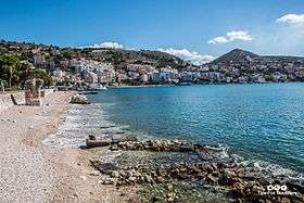
Given its coastal access and Mediterranean climate, Sarandë has become an important tourist attraction since the fall of communism in Albania. Saranda as well as the rest of the Albanian Riviera, according to The Guardian, "is set to become the new undiscovered gem of the overcrowded Med."[31] Tourism is thus the major economic resource, while other resources include services, fisheries and construction. The unemployment rate according to the population census of 2008 was 8.32%. It has been suggested that family tourism and seasonal work during the summer period help mitigate the real unemployment rate. Recently, the town has experienced an uncontrolled construction boom which may hamper the city's future tourism potential. Since 2012, the Port of Saranda is undergoing an expansion to accommodate cruise ships at its terminal.
Tourism
Tourism is the main driver of the economy of Sarandë. It is a significant tourist destination on the Ionian Sea, and by far one of the most popular destination in Albania.
It's a prosperous region with varied attractions, plants and mountains, rivers and lakes, springs and virgin beaches, citrus plantations, olive groves and vineyards, pastures and woods, fish and shellfish farming, desirable hunting places. In short, the right place for the development of tourism. Saranda's stony beaches are quite decent and there are plenty of sights in and around town, including the mesmerising ancient archaeological site of Butrint and the hypnotic Blue Eye Spring. Between Saranda and Butrint, the lovely beaches and islands of Ksamil are perfect for a dip after a day of exploring.[32]
 The Blue Eye Spring
 The view over the city and the Port of Sarandë
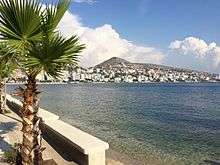 Promenade with the beach
See also
Notable people
- Vangjel Agora – actor/director[33][34]
- Niko Kacalidha – poet, author, ex-state minister.[35]
- Ilir Seitaj – four times National Chess Champion[36]
- Antonia Stergiou, athlete
- Luiza Xhuvani – actress[37][38][39]
Italian singers Albano and Romina Power dedicated a song to Saranda entitled Saranda Okinawa.
International relations
Sarandë is twinned with:
References
Notes
- 1 2 Pettifer, James. The Greek Minority in Albania – In the Aftermath of Communism. Conflict Studies Research Center, July 2001 ISBN 1-903584-35-3 – p. 12, "The concentration of ethnic Greeks in and around centres of Hellenism such as Saranda and Gjirokastra could guarantee their election there, but nowhere else in the country is success for an Omonia-based candidate possible."
- ↑ E.g., Walker, J. & C. "Turkey II: Containing the Northern Part of Greece." Published 1 November 1829 by Baldwin & Cradock, 47 Paternoster Row, London. (London: Chapman & Hall, 1844). Accessed 24 Aug 2011.
- ↑ Murzaku, Ines Angeli (2009). Returning Home to Rome – The Basilian Monks of Grottaferrata in Albania. Analekta Kryptoferris. p. 220. ISBN 978-88-89345-04-7. Retrieved 8 October 2010.
- ↑ Pearson, Owen (2004). Albania and King Zog: independence, republic and monarchy 1908–1939. I.B.Tauris. p. 470. ISBN 978-1-84511-013-0. Retrieved 8 October 2010.
- ↑ E.g., Wojskowe Zaklady Kartograficzne. Pergamon World Atlas. "Albania, Greece." Pergamon Press, Ltd. & P.W.N. Poland 1967. Sluzba Topograficzna W.P. Accessed 24 Aug 2011.
- ↑ Strabo, The Geography, Book VII, Chapter 7.5: "...these mountains one comes to Onchesmus, another harbor, opposite which lie the western extremities of Corcyraea."
- ↑ Bowden, William. Epirus Vetus: The Archaeology of a Late Antique Province. London: Duckworth, 2003, ISBN 0-7156-3116-0, p. 14. "Anchiasmos (Onchesmos)"
- ↑ Hodges, Richard. Saranda – Ancient Onchesmos: A Short History and Guide. Butrint Foundation, 2007. ISBN 99943-943-6-3
- ↑ Hammond, N.G.L. Philip of Macedon. London, UK: Duckworth, 1994. "Epirus was a land of milk and animal products...The social unit was a small tribe, consisting of several nomadic or semi-nomadic groups, and these tribes, of which more than seventy names are known, coalesced into large tribal coalitions, three in number: Thesprotians, Molossians and Chaonians...We know from the discovery of inscriptions that these tribes were speaking the Greek language (in a West-Greek dialect)."
- ↑ Talbert, Richard J.A. and Bagnall, Roger S. Barrington Atlas of the Greek and Roman World, 2000, p. 815. "harbor, cape or town in Epirus between Onchesmos and Bouthroton."
- ↑ Eidinow, Esther. Oracles, Curses, and Risk Among the Ancient Greeks. Oxford University Press, 2007. ISBN 0-19-927778-8 "Onchesmos was the principal port of Phoinike, the capital of Chaonia,..."
- 1 2 M. V. Sakellariou. Epirus, 4000 years of Greek history and civilization. Ekdotike Athenon. ISBN 978-960-213-371-2, p. 153.
- ↑ M. V. Sakellariou. Epirus, 4000 years of Greek history and civilization. Ekdotike Athenon. ISBN 978-960-213-371-2, p. 164.
- ↑ M. V. Sakellariou. Epirus, 4000 years of Greek history and civilization. Ekdotike Athenon. ISBN 978-960-213-371-2, p. 292.
- ↑ "Albania's Captives". Retrieved 13 January 2016.
- ↑ Kondis, Basil (1976). Greece and Albania: 1908–1914. Thessaloniki: Institute for Balkan Studies, New York University.
Zographos and Karapanos met at Santi Quaranda with the Commission but upon the request of Zographos the final negotiations took place in the island of Corfu... Protocol of Corfu
- ↑ Edith Pierpont Stickney. Southern Albania or northern Epirus in European international affairs, 1912–1923 Stanford University Press, 1926.
- ↑ Carr, John (2013). The Defence and Fall of Greece 1940–1941. Pen and Sword. pp. 78–79. ISBN 9781473828308.
This made the Greek war effort immeasurably easier ... overland route.
- ↑ Fischer, Bernd J. (1999). Albania at war : 1939–1945. London: Hurst. pp. 232–233. ISBN 978-1-85065-531-2.
- ↑ Law nr. 115/2014
- ↑ "Grand Hotel Saranda". grandhotelsaranda.com.
- ↑ Interactive map administrative territorial reform
- ↑ 2011 census results
- 1 2 "Vlora's communes". Retrieved 13 January 2016.
- 1 2 3 4 Sarande Municipality. "Historiku i Qytetit" (in Albanian). Retrieved 28 July 2010.
- 1 2 3 Council of Europe. "Report Submitted by Albania" (PDF). Retrieved 28 July 2010.
According to a survey held last year by the Albanian Helsinki Committee, until 1990, the city of Saranda had about 17 thousand inhabitants, with nearly 7,500 of them belonging to Greek national minority.
- 1 2 Paik, Charles M. Vance, Yongsun (2006). Managing a global workforce challenges and opportunities in international human resource management. Armonk, N.Y.: M.E. Sharpe. p. 682. ISBN 9780765620163.
- 1 2 Kallivretakis, Leonidas (1995). "Η ελληνική κοινότητα της Αλβανίας υπό το πρίσμα της ιστορικής γεωγραφίας και δημογραφίας [The Greek Community of Albania in terms of historical geography and demography." In Nikolakopoulos, Ilias, Kouloubis Theodoros A. & Thanos M. Veremis (eds). Ο Ελληνισμός της Αλβανίας [The Greeks of Albania]. University of Athens. p. 34. "Στα πλαίσια της επιτόπιας έρευνας που πραγματοποιήσαμε στην Αλβανία (Νοέμβριος-Δεκέμβριος 1992), μελετήσαμε το ζήτημα των εθνοπολιτισμικών ομάδων, όπως αυτές συνειδητοποιούνται σήμερα επί τόπου. [As part of the fieldwork we held in Albania (November–December 1992), we studied the issue of ethnocultural groups, as they are realized today on the spot.] "; pp. 42–43. "Οι πιθανοί συνδυασμοί αναδεικνύουν την κομβική θέση των Αλβανών Χριστίανών, γεγονός που έχει γίνει αντιληπτό από μερίδα της μειονοτικής ηγεσίας. [Οι πιθανοί συνδυασμοί αναδεικνύουν την κομβική θέση των Αλβανών Χριστίανών, γεγονός που έχει γίνει αντιληπτό από μερίδα της μειονοτικής ηγεσίας.]"; p. 43. "Το ίδιο ισχύει και στην περίπτωση των Αγίων Σαράντα, αν και ο Δήμος πέρασε στα χέρια της μειονότητας, χάρις στις ψήφους των Αλβανών Χριστιανών. [The same applies in the case of Saranda, though the municipality passed into the hands of the minority, thanks to the votes of Albanian Christians.]"; p. 51. "Ε Έλληνες, ΑΧ Αλβανοί Ορθόδοξοι Χριστιανοί, AM Αλβανοί Μουσουλμάνοι, Μ Μικτός πληθυσμός.... SARANDE ΣΑΡΑΧΤΙ (ΑΓ. ΣΑΡΑΝΤΑ) 17555 Μ(8055 AM + 6500 Ε + 3000 ΑΧ)."
- ↑ Pettifer, James. The Greek Minority in Albania – In the Aftermath of Communism. Conflict Studies Research Center, July 2001 ISBN 1-903584-35-3 – p. 11, "In 1991, Greek shops were attacked in the coastal town of Saranda, home to a large minority population, and inter-ethnic relations throughout Albania worsened."
- 1 2 Human rights in post-communist Albania, Fred Abrahams, Human Rights Watch, p.119 "The town of Saranda has an ethnic Greek population large enough to warrant a school, but one still does not exist".
- ↑ 2009's hot new beach destination: Albania, www.guardian.co.uk
- ↑ Planet, Lonely. "Saranda, Albania – Lonely Planet". lonelyplanet.com.
- ↑ "Vangjel Agora". IMDb. Retrieved 13 January 2016.
- ↑ http://www.sgourosmp3.com/Sakharov-Sgouros.htm "Actor/Director, National Theater of Agioi Saranta"
- ↑ "Page not found" (PDF). Retrieved 13 January 2016.
- ↑ Frasheri, Dash. "Shahu shqiptar, 76 vjet histori përmes kutive" (in Albanian). Retrieved 24 September 2010.
- ↑ "Luiza Xhuvani". IMDb. Retrieved 13 January 2016.
- ↑ http://lajme.parajsa.com/Kulture/id_24381/
- ↑ "Luiza Xhuvani". Retrieved 13 January 2016.
- ↑ "AllCorfu.Com: Corfu's Twin Cities". allcorfu.com. Retrieved 25 February 2010.
| Transport | |
|---|---|
Municipalities in Albania are administrative divisions made up of local administrative units and their inclusive villages. | ||
| (61) |
|  |
Administrative Divisions of Vlorë County | ||
|---|---|---|
County Seat: Vlorë | ||
| Municipality of Delvinë |  | |
| Municipality of Finiq | ||
| Municipality of Himara | ||
| Municipality of Konispol | ||
| Municipality of Sarandë | ||
| Municipality of Selenicë | ||
| Municipality of Vlorë | ||
Subdivisions of Sarandë Municipality | ||
|---|---|---|
Municipal Seat: Sarandë | ||
| Administrative Unit of Ksamil |  | |
| Administrative Unit of Sarandë | ||
| Cities | |
|---|---|
| Villages | |
| National Parks | |
| See also | |